Tangalan
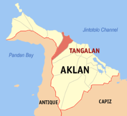
Tangalan (Bayan ng Tangalan) er en kommune på Filippinene. Kommunen ligger på øya Panay, og tilhører provinsen Aklan.
| Tangalan | |||
|---|---|---|---|
 | |||
| Land | |||
| Status | kommune | ||
| Postnummer | 5612 | ||
| Retningsnummer | 36 | ||
| Areal | 74,59 km² | ||
| Befolkning | 23 704[1] (2020) | ||
| Bef.tetthet | 317,79 innb./km² | ||
| Antall husholdninger | 5 808 | ||
| Språk | Aklanon, Hiligaynon, tagalog | ||
| Høyde o.h. | 39 meter | ||
| Nettside | www | ||
 Tangalan 11°46′39″N 122°15′37″Ø | |||

Tangalan var tidligere en arrabal til Makato. Da den ble utskilt omfattet den de følgende barrioene: Tondog, Jawili, Dumatad, Afga, Baybay, Dapdap, Pudyot, Tagas, Tamalagon, Panayakan, Vivo, Lanipga, Napatag og Tamokoe.[2]
Barangayer
redigerTangalan er inndelt i 15 barangayer.[3]
- Afga
- Baybay
- Dapdap
- Dumatad
- Jawili
- Lanipga
- Napatag
- Panayakan
- Poblacion
- Pudiot
- Tagas
- Tamalagon
- Tamokoe
- Tondog
- Vivo
Referanser
rediger- ^ «2020 Census of Population and Housing (2020 CPH) Population Counts Declared Official by the President». folketellingen 2020. Filippinenes statistikkbyrå. 7. juli 2021.
- ^ «Republic Act No. 285; An Act Creating the Municipality of Tangalan in the Province of Capiz». The Corpus Juris. 16. juni 1948. Besøkt 22. oktober 2016.
- ^ Barangays in Tangalan 2018 Philippine Standard Geographic Code (PSGC)
Kilder
rediger- 2015 Census of Population and Housing Report Philippine Statistics Authority