Fil:Roman Gaul - AD 400.png
Størrelse på denne forhåndsvisningen: 800 × 487 piksler. Andre oppløsninger: 320 × 195 piksler | 640 × 389 piksler | 1 024 × 623 piksler | 1 369 × 833 piksler.
Opprinnelig fil (1 369 × 833 piksler, filstørrelse: 1,13 MB, MIME-type: image/png)
| Denne filen er fra Wikimedia Commons og kan brukes av andre prosjekter. Informasjonen fra filbeskrivelsessiden vises nedenfor. |

|
Dette bildet bør gjenskapes med hjelp av vektorgrafikk som en SVG-fil. Dette har flere fordeler, se Commons:Media for cleanup for mer informasjon. Hvis en SVG-fil med dette bildet er tilgjengelig, vennligst last den opp. Etter opplasting erstatt denne malen med {{vector version available|nytt bilde.svg}}.
|
Beskrivelse
| Beskrivelse |
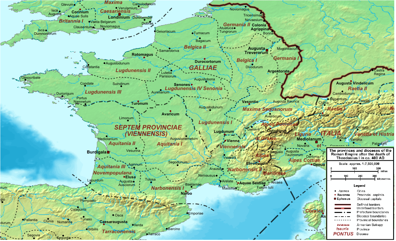
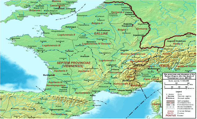
English: Map of the Roman Empire ca. 400 AD, showing the administrative division into dioceses and provinces, as well as the major cities. The demarcation between Eastern and Western Empires is noted in red. |
| Dato | (UTC) |
| Kilde |
This file was derived from: The Roman Empire ca 400 AD.png: |
| Opphavsperson |
|
| This is a retouched picture, which means that it has been digitally altered from its original version. Modifications: Roman Gaul. The original can be viewed here: The Roman Empire ca 400 AD.png:
|
Lisensiering
Jeg, rettighetsinnehaver av dette arbeidet, publiserer det herved under følgende lisens:
| Jeg, opphavsrettensholderen til dette verket, frigir dette verket til allmennheten. Dette gjelder på verdensbasis. I enkelte land kan dette være juridisk umulig. I så fall: Jeg gir hvem som helst retten til å bruke dette verket for ethvert formål, uten noen vilkår, med mindre slike vilkår kreves ved lov. |
Orginal opplastningslogg
This image is a derivative work of the following images:
- File:The_Roman_Empire_ca_400_AD.png licensed with PD-self
- 2011-07-21T13:03:22Z Cplakidas 4339x2689 (11429663 Bytes) fixed Persian border, differentiated between Eastern and Western empire, different borders for praet. prefectures
- 2009-03-21T02:37:17Z Cplakidas 4475x2600 (10476876 Bytes) minor corrections
- 2008-05-29T12:30:03Z Cplakidas 3800x2370 (8491181 Bytes)
- 2008-05-29T12:17:05Z Cplakidas 4560x2850 (11764337 Bytes) clearer version & addition of the Armenian satrapies
- 2007-12-30T02:02:48Z Cplakidas 3380x2120 (6247724 Bytes) added names of dioceses, legend box, various minor adjustments
- 2007-12-13T14:27:35Z Cplakidas 3550x2200 (6970232 Bytes) new improved version made with Inkscape, slight corrections in borders, added several cities in Africa & Spain
- 2007-11-12T19:27:37Z Cplakidas 3550x2200 (4979411 Bytes) minor corrections in southern Gaul
- 2007-11-05T12:58:04Z Cplakidas 3550x2200 (4977196 Bytes) New version, with some corrections & additions
- 2007-10-31T16:55:48Z Cplakidas 3436x2142 (4722554 Bytes) {{Information |Description=Map of the [[Roman Empire]] ca. 400 AD, showing the administrative division into dioceses and provinces, as well as the major cities. The demarcation between Eastern and Western Empires is noted in
Uploaded with derivativeFX
Filhistorikk
Klikk på et tidspunkt for å vise filen slik den var på det tidspunktet.
| Dato/klokkeslett | Miniatyrbilde | Dimensjoner | Bruker | Kommentar | |
|---|---|---|---|---|---|
| nåværende | 22. des. 2013 kl. 00:33 | | 1 369 × 833 (1,13 MB) | Jbribeiro1 | == {{int:filedesc}} == {{Information |Description=Map of the Roman Empire ca. 400 AD, showing the administrative division into dioceses and provinces, as well as the major cities. The demarcation between Eastern and Western Empires is noted in red.... |
Filbruk
Den følgende siden bruker denne filen:
Global filbruk
Følgende andre wikier bruker denne filen:
- Bruk i ar.wikipedia.org
- Bruk i bg.wikipedia.org
- Bruk i br.wikipedia.org
- Bruk i ca.wikipedia.org
- Bruk i da.wikipedia.org
- Bruk i de.wikipedia.org
- Bruk i el.wikipedia.org
- Bruk i en.wikipedia.org
- Bruk i es.wikipedia.org
- Bruk i et.wikipedia.org
- Bruk i fi.wikipedia.org
- Bruk i fr.wikipedia.org
- Bruk i la.wikipedia.org
- Bruk i lt.wikipedia.org
- Bruk i oc.wikipedia.org
- Bruk i pt.wikipedia.org
- Bruk i uk.wikipedia.org
Vis mer global bruk av denne filen.