Fil:Babylon 1829 cropped.gif
Babylon_1829_cropped.gif (489 × 356 piksler, filstørrelse: 75 KB, MIME-type: image/gif)
| Denne filen er fra Wikimedia Commons og kan brukes av andre prosjekter. Informasjonen fra filbeskrivelsessiden vises nedenfor. |
| Beskrivelse |
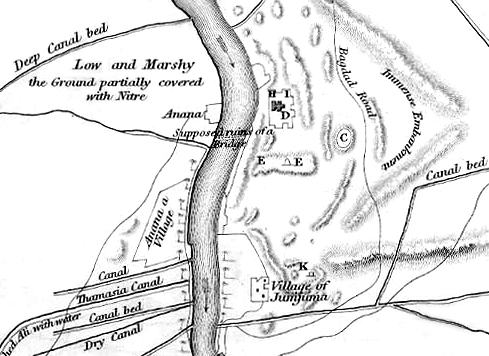
English: Map of the site of Babylon prior to its excavation later in the 19th century. |
| Dato | (UTC) |
| Kilde |
|
| Opphavsperson |
|
| This is a retouched picture, which means that it has been digitally altered from its original version. Modifications: Cropped to show southern area, highlighting the Jumjuma mound. The original can be viewed here: Babylon 1829.jpg:
|
|
Dette verket er offentlig eiendom i Norge, EU og land der den opphavsrettslige vernetiden etter opphavsmannens død er 70 år eller kortere. Merk at noen land har lengre vernetid.
| |
| Denne filen har blitt identifisert til å være fri for kjente restriksjoner under lov om opphavsrett, inkludert alle relaterte og nærstående rettigheter. | |
Orginal opplastningslogg
This image is a derivative work of the following images:
- File:Babylon_1829.jpg licensed with PD-old
- 2010-06-06T22:50:24Z ChrisO 1065x1464 (228517 Bytes) {{Information |Description={{en|1=Map of the site of Babylon prior to its excavation later in the 19th century.}} |Source=Ground Plan of the Remains at & near Babylon |Author=Captain R. Mignan |Date=October 1829 |Permission=
Uploaded with derivativeFX
Filhistorikk
Klikk på et tidspunkt for å vise filen slik den var på det tidspunktet.
| Dato/klokkeslett | Miniatyrbilde | Dimensjoner | Bruker | Kommentar | |
|---|---|---|---|---|---|
| nåværende | 16. jun. 2010 kl. 22:56 | | 489 × 356 (75 KB) | ChrisO | |
| 7. jun. 2010 kl. 01:07 |  | 489 × 356 (88 KB) | ChrisO | {{Information |Description={{en|1=Map of the site of Babylon prior to its excavation later in the 19th century.}} |Source=*File:Babylon_1829.jpg |Date=2010-06-06 23:07 (UTC) |Author=*File:Babylon_1829.jpg: Captain R. Mignan *derivative work: ~ |
Filbruk
Den følgende siden bruker denne filen:
Global filbruk
Følgende andre wikier bruker denne filen:
- Bruk i ar.wikipedia.org
- Bruk i bn.wikipedia.org
- Bruk i en.wikipedia.org
- Bruk i es.wikipedia.org
- Bruk i fa.wikipedia.org
- Bruk i fr.wikipedia.org
- Bruk i he.wikipedia.org
- Bruk i hyw.wikipedia.org
- Bruk i uk.wikipedia.org