Fil:Tokat districts.png
Størrelse på denne forhåndsvisningen: 776 × 600 piksler. Andre oppløsninger: 311 × 240 piksler | 621 × 480 piksler | 994 × 768 piksler | 1 056 × 816 piksler.
Opprinnelig fil (1 056 × 816 piksler, filstørrelse: 34 KB, MIME-type: image/png)
| Denne filen er fra Wikimedia Commons og kan brukes av andre prosjekter. Informasjonen fra filbeskrivelsessiden vises nedenfor. |
Beskrivelse
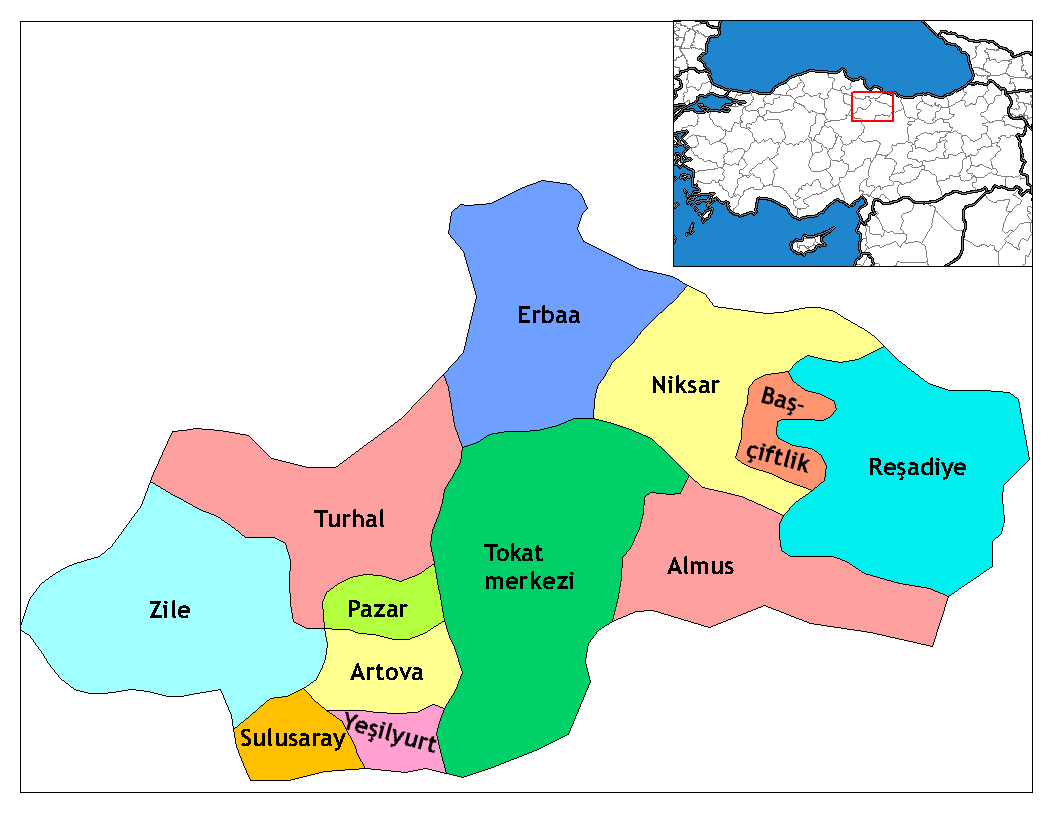
| Beskrivelse | Map of the districts of Tokat province in Turkey. Created by Rarelibra 17:52, 4 December 2006 (UTC) for public domain use, using MapInfo Professional v8.5 and various mapping resources. Edited by One Homo Sapiens Corrected text where İ,Ş,ı,ğ,or ş occurs in name. Source: [statoids-com]. Increased font size and enhanced color differences among adjacent districts. |
| Dato | 4. desember 2006 (original upload date) |
| Kilde | No machine-readable source provided. Own work assumed (based on copyright claims). |
| Opphavsperson | Ingen maskinlesbar opphavsperson oppgitt. Rarelibra er antatt opphavsperson, basert på opplysninger om opphavsrett. |
Lisensiering
| Jeg, opphavsrettensholderen til dette verket, frigir dette verket til allmennheten. Dette gjelder på verdensbasis. I enkelte land kan dette være juridisk umulig. I så fall: Jeg gir hvem som helst retten til å bruke dette verket for ethvert formål, uten noen vilkår, med mindre slike vilkår kreves ved lov. |
Filhistorikk
Klikk på et tidspunkt for å vise filen slik den var på det tidspunktet.
| Dato/klokkeslett | Miniatyrbilde | Dimensjoner | Bruker | Kommentar | |
|---|---|---|---|---|---|
| nåværende | 29. des. 2008 kl. 04:33 | | 1 056 × 816 (34 KB) | One Homo Sapiens | Corrected text where İ,Ş,ı,ğ,or ş occurs in name. Source: [statoids-com]. Increased font size and enhanced color differences among adjacent districts. |
| 4. des. 2006 kl. 19:52 |  | 1 056 × 816 (33 KB) | Rarelibra | Map of the districts of Tokat province in Turkey. Created by ~~~~ for public domain use, using MapInfo Professional v8.5 and various mapping resources. |
Filbruk
Den følgende siden bruker denne filen:
Global filbruk
Følgende andre wikier bruker denne filen:
- Bruk i ar.wikipedia.org
- Bruk i ast.wikipedia.org
- Bruk i ca.wikipedia.org
- Bruk i de.wikipedia.org
- Bruk i diq.wikipedia.org
- Bruk i en.wikipedia.org
- Talk:Provinces of Turkey
- Tokat Province
- Yeşilyurt, Tokat
- User talk:Rarelibra/Maps4
- Reşadiye shooting
- List of populated places in Tokat Province
- Districts of Turkey
- Governor of Tokat
- Başçiftlik District
- Tokat District
- Turhal District
- Reşadiye District
- Artova District
- Sulusaray District
- Yeşilyurt District, Tokat
- Zile District
- Almus District
- Erbaa District
- Niksar District
- Pazar District, Tokat
- Bruk i en.wiktionary.org
- Bruk i eo.wikipedia.org
- Bruk i es.wikipedia.org
- Bruk i eu.wikipedia.org
- Bruk i fa.wikipedia.org
Vis mer global bruk av denne filen.