Fil:Teterboro airport diagram.png
Størrelse på denne forhåndsvisningen: 414 × 599 piksler. Andre oppløsninger: 166 × 240 piksler | 331 × 480 piksler | 784 × 1 135 piksler.
Opprinnelig fil (784 × 1 135 piksler, filstørrelse: 25 KB, MIME-type: image/png)
| Denne filen er fra Wikimedia Commons og kan brukes av andre prosjekter. Informasjonen fra filbeskrivelsessiden vises nedenfor. |
Beskrivelse
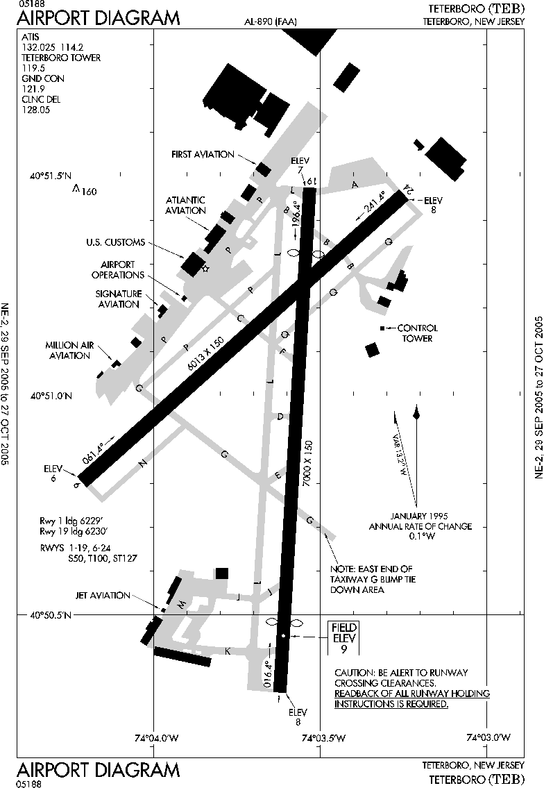
| Beskrivelse | FAA airport diagram for Teterboro Airport (TEB) in Teterboro, New Jersey, United States. |
| Dato | Effective 2005-09-29 to 2005-10-27. |
| Kilde |
http://www.naco.faa.gov/d-tpp/0510/00890AD.PDF Note: this URL changes every 28 days; the airport article should contain a link to the current FAA diagram. |
| Opphavsperson | Produced by the National Aeronautical Charting Office (NACO), a department of the Federal Aviation Administration (FAA). |
| Tillatelse (Gjenbruk av denne filen) |
Public domain. |
| Andre versjoner | Image:TEB - FAA airport diagram.gif / Image:00890AD.gif |
Lisensiering
This image or file is a work of a Federal Aviation Administration employee, taken or made as part of that person's official duties. As a work of the U.S. federal government, the image is in the public domain in the United States.
|
 |
Orginal opplastningslogg
Originally from en:wikipedia; description page is/was here. (All user names refer to en.wikipedia)
- 2005-10-20 11:13 Zyxw 805×1237×8 (35191 bytes) FAA diagram of [[Teterboro Airport]] (TEB) http://www.naco.faa.gov/d-tpp/0510/00890AD.PDF
Filhistorikk
Klikk på et tidspunkt for å vise filen slik den var på det tidspunktet.
| Dato/klokkeslett | Miniatyrbilde | Dimensjoner | Bruker | Kommentar | |
|---|---|---|---|---|---|
| nåværende | 11. okt. 2007 kl. 21:34 | | 784 × 1 135 (25 KB) | Skies | {{Information |Description=FAA diagram of en:Teterboro Airport (TEB) http://www.naco.faa.gov/d-tpp/0510/00890AD.PDF en:commons:category:Teterboro Airport en:commons:category:Federal Aviation Administration en:commons:category:Maps |
Filbruk
Det er ingen sider som bruker denne filen.
Global filbruk
Følgende andre wikier bruker denne filen:
- Bruk i arz.wikipedia.org
- Bruk i ceb.wikipedia.org
- Bruk i en.wikivoyage.org
- Bruk i es.wikipedia.org
- Bruk i nl.wikipedia.org
- Bruk i pt.wikipedia.org
- Bruk i www.wikidata.org