Fil:Tet-Offensive-Map.jpg
Ingen høyere oppløsning tilgjengelig.
Tet-Offensive-Map.jpg (330 × 448 piksler, filstørrelse: 21 KB, MIME-type: image/jpeg)
| Denne filen er fra Wikimedia Commons og kan brukes av andre prosjekter. Informasjonen fra filbeskrivelsessiden vises nedenfor. |
Beskrivelse

|
Dette bildet bør gjenskapes med hjelp av vektorgrafikk som en SVG-fil. Dette har flere fordeler, se Commons:Media for cleanup for mer informasjon. Hvis en SVG-fil med dette bildet er tilgjengelig, vennligst last den opp. Etter opplasting erstatt denne malen med {{vector version available|nytt bilde.svg}}.
|


|
This map has been uploaded by Electionworld from en.wikipedia.org to enable the |
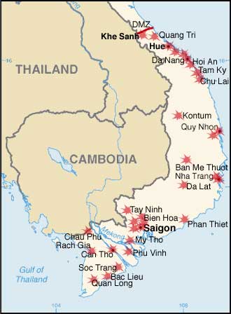
Modified by me from a CIA Factbook map.
Map showing the major targets of the Tet Offensive January-February, 1968
Lisensiering
Dette biletet er offentleg eigedom av di det inneheld tilfang som kjem frå Sambandsstatanes Central Intelligence Agency si Allkunnebok over verda.
|
 |
Filhistorikk
Klikk på et tidspunkt for å vise filen slik den var på det tidspunktet.
| Dato/klokkeslett | Miniatyrbilde | Dimensjoner | Bruker | Kommentar | |
|---|---|---|---|---|---|
| nåværende | 7. des. 2006 kl. 23:34 | | 330 × 448 (21 KB) | Electionworld | {{ew|en|KarlBunker}} Modified by me from a CIA Factbook map. Map showing the major targets of the Tet Offensive January-February, 1968 == Licensing == {{PD-USGov-CIA-WF}} |
Filbruk
Den følgende siden bruker denne filen:
Global filbruk
Følgende andre wikier bruker denne filen:
- Bruk i ca.wikipedia.org
- Bruk i da.wikipedia.org
- Bruk i en.wikipedia.org
- Bruk i eo.wikipedia.org
- Bruk i fi.wikipedia.org
- Bruk i fr.wikipedia.org
- Bruk i he.wikipedia.org
- Bruk i nl.wikipedia.org
- Bruk i pl.wikipedia.org
- Bruk i pl.wikibooks.org
- Bruk i ro.wikipedia.org
- Bruk i sh.wikipedia.org
- Bruk i simple.wikipedia.org
- Bruk i sk.wikipedia.org
- Bruk i vi.wikipedia.org