Fil:1902 Subig Bay (Subic Bay) Luzon, Philippines nautical chart 4254, by Manila Sub Office, United States Coast and Geodetic Survey.jpg

Størrelse på denne forhåndsvisningen: 476 × 600 piksler. Andre oppløsninger: 190 × 240 piksler | 381 × 480 piksler | 610 × 768 piksler | 813 × 1 024 piksler | 1 626 × 2 048 piksler | 2 672 × 3 366 piksler.
Opprinnelig fil (2 672 × 3 366 piksler, filstørrelse: 1,21 MB, MIME-type: image/jpeg)
| Denne filen er fra Wikimedia Commons og kan brukes av andre prosjekter. Informasjonen fra filbeskrivelsessiden vises nedenfor. |
Beskrivelse
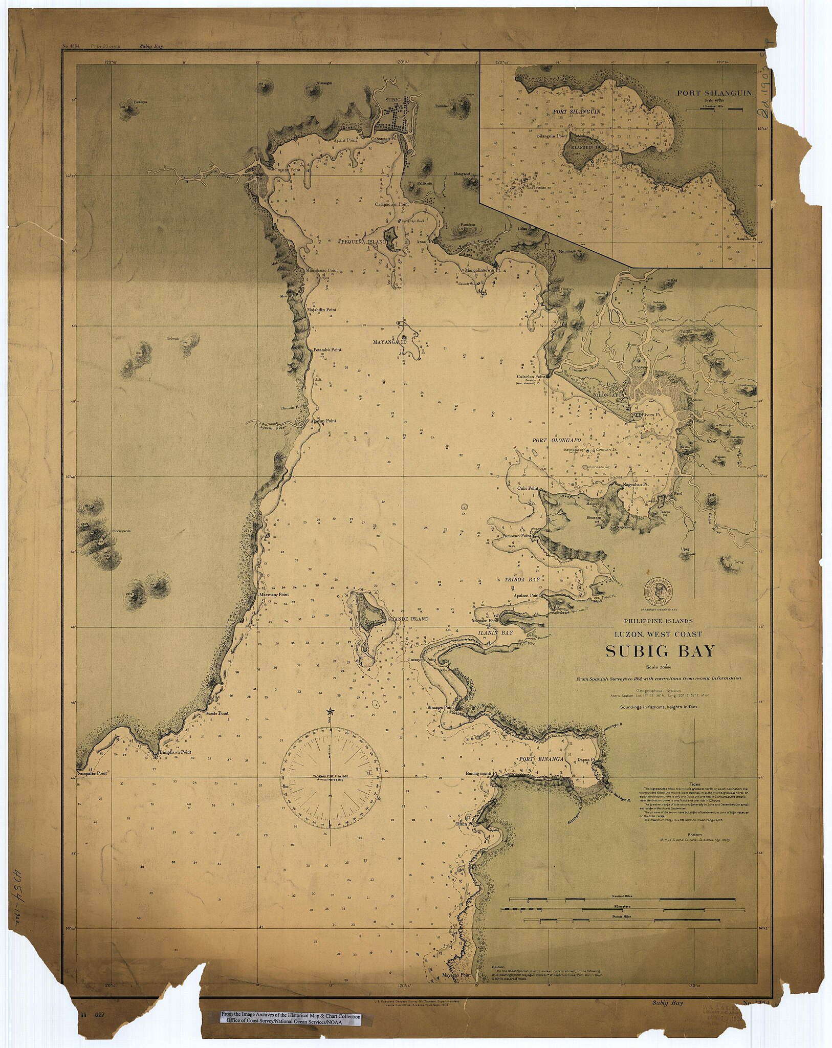
Scanned image of US Coast & Geodetic Survey Manila Office nautical chart #4254 Subig (Subic) Bay, Luzon, Philippines, 1902.
From the Image Archives of the Historical Map & Chart Collection archive copy at the Wayback Machine/Office of Coast Survey/National Ocean Service/NOAA/United States government. Converted from MrSID to JPEG format for upload to Commons.
_4254,_by_Manila_Sub_Office,_United_States_Coast_and_Geodetic_Survey_(cropped).jpg)
_Luzon,_Philippines_nautical_chart_4254,_by_Manila_Sub_Office,_United_States_Coast_and_Geodetic_Survey.jpg)
Lisensiering
This image is in the public domain because it contains materials that originally came from the U.S. National Oceanic and Atmospheric Administration, taken or made as part of an employee's official duties.
|
Filhistorikk
Klikk på et tidspunkt for å vise filen slik den var på det tidspunktet.
| Dato/klokkeslett | Miniatyrbilde | Dimensjoner | Bruker | Kommentar | |
|---|---|---|---|---|---|
| nåværende | 17. mar. 2006 kl. 03:02 | | 2 672 × 3 366 (1,21 MB) | Cdc~commonswiki | Scanned image of US Coast & Geodetic Survey Manila Office nautical chart #4254 Subig (Subic) Bay, Luzon, Philippines, 1902. From the Image Archives of the [http://chartmaker.ncd.noaa.gov/csdl/ctp/abstract.htm Historical Map & Chart Collection]/Office of |
Filbruk
Den følgende siden bruker denne filen:
Global filbruk
Følgende andre wikier bruker denne filen:
- Bruk i ast.wikipedia.org
- Bruk i da.wikipedia.org
- Bruk i en.wikipedia.org
- Bruk i es.wikipedia.org
- Bruk i fr.wikipedia.org
- Bruk i id.wikipedia.org
- Bruk i ja.wikipedia.org
- Bruk i nl.wikipedia.org
- Bruk i pt.wikipedia.org
- Bruk i ru.wikipedia.org
- Bruk i sv.wikipedia.org
- Bruk i tl.wikipedia.org
- Bruk i vi.wikipedia.org
- Bruk i www.wikidata.org
- Bruk i zh.wikipedia.org
_Luzon,_Philippines_nautical_chart_4254,_by_Manila_Sub_Office,_United_States_Coast_and_Geodetic_Survey.jpg)