Fil:Serbian empire06 map.png

Størrelse på denne forhåndsvisningen: 777 × 599 piksler. Andre oppløsninger: 311 × 240 piksler | 622 × 480 piksler | 984 × 759 piksler.
Opprinnelig fil (984 × 759 piksler, filstørrelse: 74 KB, MIME-type: image/png)
| Denne filen er fra Wikimedia Commons og kan brukes av andre prosjekter. Informasjonen fra filbeskrivelsessiden vises nedenfor. |
Beskrivelse
| Beskrivelse |
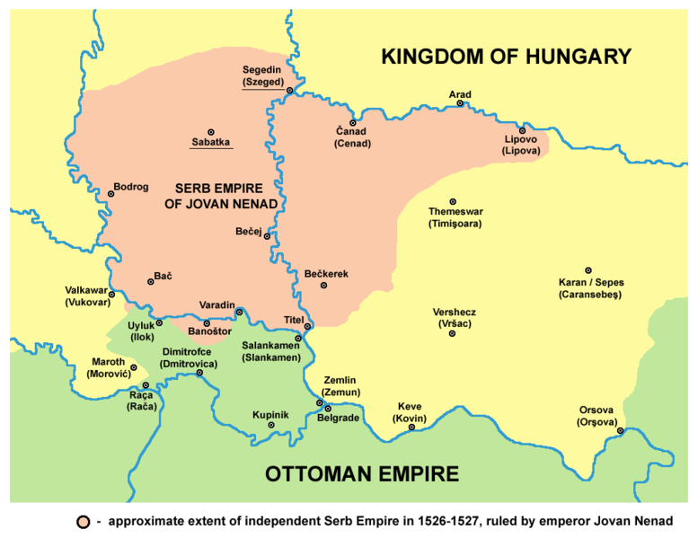
English: historical map showing Serb Empire of Jovan Nenad in 1526-1527, English language version.
Српски / srpski: историјска мапа која приказује Српско царство Јована Ненада 1526-1527. године, верзија на енглеском језику. |
| Dato | 9. februar 2009 (original upload date) |
| Kilde | No machine-readable source provided. Own work assumed (based on copyright claims). |
| Opphavsperson | Ingen maskinlesbar opphavsperson oppgitt. PANONIAN er antatt opphavsperson, basert på opplysninger om opphavsrett. |
References
- Veselin P. Dželetović, Poslednji srpski car - Jovan Nenad, Poeta - Beograd, 2007.
- Dr Aleksa Ivić, Istorija Srba u Vojvodini, Novi Sad, 1929.
- Milan Tutorov, Mala Raška a u Banatu, Zrenjanin, 1991.
- Drago Njegovan, Prisajedinjenje Vojvodine Srbiji, Novi Sad, 2004.
- Dr. Dušan J. Popović, Srbi u Vojvodini, knjiga 1, Novi Sad, 1990.
- Peter Rokai, Zoltan Đere, Tibor Pal, Aleksandar Kasaš, Istorija Mađara, Beograd, 2002.
- Vladimir Ćorović, Ilustrovana istorija Srba, knjiga četvrta, Beograd, 2006.
- Dr Milenko Palić, Srbi u Mađarskoj - Ugarskoj do 1918, Novi Sad, 1995.
- The Times History of Europe, Times Books, 2002.
Source and licence
self made map by user:PANONIAN
Lisensiering
| Jeg, opphavsrettensholderen til dette verket, frigir dette verket til allmennheten. Dette gjelder på verdensbasis. I enkelte land kan dette være juridisk umulig. I så fall: Jeg gir hvem som helst retten til å bruke dette verket for ethvert formål, uten noen vilkår, med mindre slike vilkår kreves ved lov. |
Filhistorikk
Klikk på et tidspunkt for å vise filen slik den var på det tidspunktet.
| Dato/klokkeslett | Miniatyrbilde | Dimensjoner | Bruker | Kommentar | |
|---|---|---|---|---|---|
| nåværende | 14. apr. 2015 kl. 18:57 | | 984 × 759 (74 KB) | PANONIAN | corrections |
| 29. nov. 2014 kl. 16:54 |  | 984 × 759 (74 KB) | PANONIAN | aesthetics | |
| 9. nov. 2011 kl. 16:54 |  | 982 × 759 (74 KB) | PANONIAN | few corrections: Ilok and Rača were Ottoman, Sotin was controlled by Jovan Nenad | |
| 12. jul. 2009 kl. 14:11 |  | 982 × 759 (70 KB) | PANONIAN | ||
| 16. mar. 2009 kl. 22:06 |  | 545 × 452 (43 KB) | PANONIAN | ||
| 10. feb. 2009 kl. 01:49 |  | 632 × 555 (59 KB) | PANONIAN | historical map of empire of Jovan Nenad - English version (self made) {{PD-self}} Category:Maps of the history of Vojvodina Category:Maps of the history of Serbia |
Filbruk
Det er ingen sider som bruker denne filen.
Global filbruk
Følgende andre wikier bruker denne filen:
- Bruk i bg.wikipedia.org
- Bruk i de.wikipedia.org
- Bruk i en.wikipedia.org
- Bruk i es.wikipedia.org
- Bruk i gl.wikipedia.org
- Bruk i hr.wikipedia.org
- Bruk i ja.wikipedia.org
- Bruk i lt.wikipedia.org
- Bruk i mk.wikipedia.org
- Bruk i ro.wikipedia.org
- Bruk i sh.wikipedia.org
- Bruk i sl.wikipedia.org