Fil:Satellite Image of Earth's Interrelated Systems and Climate - GPN-2002-000121.jpg

Størrelse på denne forhåndsvisningen: 600 × 600 piksler. Andre oppløsninger: 240 × 240 piksler | 480 × 480 piksler | 768 × 768 piksler | 1 024 × 1 024 piksler | 2 350 × 2 350 piksler.
Opprinnelig fil (2 350 × 2 350 piksler, filstørrelse: 1,28 MB, MIME-type: image/jpeg)
| Denne filen er fra Wikimedia Commons og kan brukes av andre prosjekter. Informasjonen fra filbeskrivelsessiden vises nedenfor. |
| Beskrivelse |
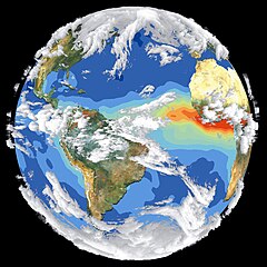
English: Satellite data and images such as those presented in this image of Earth give scientists a more comprehensive view of the Earth's interrelated systems and climate. Four different satellites contributed to the making of this image. Sea-viewing Wide Field-of-view Sensor (SeaWiFS) provided the land image layer and is a true color composite of land vegetation for cloud-free conditions from September 18 to October 3, 1997. Each red dot over South America and Africa represents a fire detected by the Advanced Very High Resolution Radiometer. The oceanic aerosol layer is based on National Oceanic and Atmospheric Administration (NOAA) data and is caused by biomass burning and windblown dust over Africa. The cloud layer is a composite of infrared images from four geostationary weather satellites?NOAA's GOES 8 and 9, the European Space Agency's METEOSAT, and Japan's GMS 5. |
|||||
| Dato | ||||||
| Kilde | Great Images in NASA Description | |||||
| Opphavsperson | NASA | |||||
| Tillatelse (Gjenbruk av denne filen) |
|

This image or video was catalogued by Goddard Space Flight Center of the United States National Aeronautics and Space Administration (NASA) under Photo ID: GPN-2002-000121 and Alternate ID: 119. This tag does not indicate the copyright status of the attached work. A normal copyright tag is still required. See Commons:Licensing. Other languages:
|
Filhistorikk
Klikk på et tidspunkt for å vise filen slik den var på det tidspunktet.
| Dato/klokkeslett | Miniatyrbilde | Dimensjoner | Bruker | Kommentar | |
|---|---|---|---|---|---|
| nåværende | 14. apr. 2015 kl. 09:50 | | 2 350 × 2 350 (1,28 MB) | Jcpag2012 | cropped from black borders |
| 10. apr. 2009 kl. 00:54 |  | 2 700 × 3 214 (2,91 MB) | BotMultichillT | {{Information |Description={{en|1=Satellite data and images such as those presented in this image of Earth give scientists a more comprehensive view of the Earth's interrelated systems and climate. Four different satellites contributed to the making of th |
Filbruk
Den følgende siden bruker denne filen:
Global filbruk
Følgende andre wikier bruker denne filen:
- Bruk i ar.wikipedia.org
- Bruk i de.wikipedia.org
- Bruk i el.wikipedia.org
- Bruk i en.wikipedia.org
- Bruk i it.wikipedia.org