Fil:Ph map manila.svg

Opprinnelig fil (SVG-fil, standardstørrelse 764 × 897 piksler, filstørrelse: 2,43 MB)
| Denne filen er fra Wikimedia Commons og kan brukes av andre prosjekter. Informasjonen fra filbeskrivelsessiden vises nedenfor. |
|
Beskrivelse
| Beskrivelse |
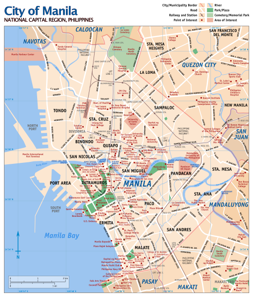
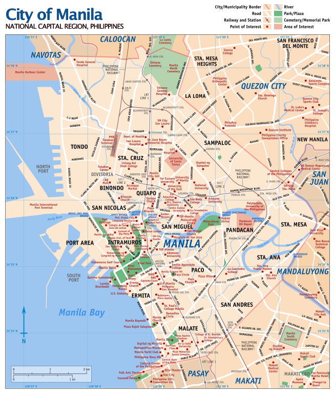
English: Street map of Manila, Philippines with points of interest indicated. This is an SVG version of Media:Ph map manila large.png. Updated for 2006. |
| Dato | |
| Kilde | Eget verk |
| Opphavsperson | Eugene Alvin Villar (seav) |
| Andre versjoner |
|

⧼licensing⧽

|
Det tillates at dette dokumentet kopieres, distribueres og/eller modifiseres under retningslinjene som beskrevet i GNU fri dokumentasjonslisens, versjon 1.2 eller senere utgave utgitt av Free Software Foundation; med alle seksjoner, uten noen forsidetekster og baksidetekster. En kopi av lisensen er inkludert i avsnittet GNU Free Documentation License. |
- Du står fritt:
- til å dele – til å kopiere, distribuere og overføre verket
- til å blande – til å endre verket
- Under de følgende betingelsene:
- navngivelse – Du må kreditere verket på passende vis, lenke til lisensen og indikere hvorvidt det har blitt gjort endringer. Du kan gjøre det på enhver rimelig måte, men ikke på en måte som antyder at lisensgiveren støtter deg eller din bruk av verket.
- del på samme vilkår – Dersom du remikser, omarbeider eller på annen måte bygger på dette verket, må du kun distribuere resultatet under den samme eller en samsvarende lisens som denne.

|
If you choose to use this work under the Creative Commons license stated on this page, the author, Eugene Alvin Villar (seav), would like you to attribute the work to him (among other requirements such as indicating that the work is licensed under the Creative Commons) with the following text or similar:
© Eugene Alvin Villar, 2007
His name should be a link to his Wikimedia Commons userpage. If a link is not possible, then the url should be placed in parentheses after the name. If the work has been substantially altered by other people (see the File history section below), then this particular attribution requirement is waived, which means you can attribute the work in any reasonable manner. This attribution requirement is provided pursuant to the Creative Commons Attribution mechanism where "you must attribute the work in the manner specified by the author or licensor (but not in any way that suggests that they endorse you or your use of the work)." (See "Attribution" in the Creative Commons website.)
|
Filhistorikk
Klikk på et tidspunkt for å vise filen slik den var på det tidspunktet.
| Dato/klokkeslett | Miniatyrbilde | Dimensjoner | Bruker | Kommentar | |
|---|---|---|---|---|---|
| nåværende | 31. mai 2021 kl. 04:19 | | 764 × 897 (2,43 MB) | HueMan1 | attempt 2 |
| 31. mai 2021 kl. 04:19 |  | 764 × 897 (2,52 MB) | HueMan1 | Reverted to version as of 15:19, 22 October 2013 (UTC) | |
| 31. mai 2021 kl. 04:18 |  | 815 × 957 (1,37 MB) | HueMan1 | removed "city"; some optimisation | |
| 22. okt. 2013 kl. 17:19 |  | 764 × 897 (2,52 MB) | Jeromesandilanico | Places and Names are Fixed and Updated | |
| 7. feb. 2007 kl. 14:16 |  | 764 × 897 (3,09 MB) | Seav | Saved using Inkscape (to hopefully fix rendering issues) | |
| 13. jan. 2007 kl. 15:09 |  | 765 × 897 (1,9 MB) | Seav | Previous SVG was not being interpreted by Wikimedia's SVG "plug-in". Now it's not viewable in Firefox, though. | |
| 10. jan. 2007 kl. 19:10 |  | 765 × 897 (1,9 MB) | Seav | Added N and E to coordinates | |
| 10. jan. 2007 kl. 18:24 |  | 765 × 897 (1,89 MB) | Seav | Added north direction arrow and coordinate grid. | |
| 9. jan. 2007 kl. 00:55 |  | 765 × 897 (1,85 MB) | Seav | removed outer black border (will not consistently show up in thumbnails); fixed map legend | |
| 7. jan. 2007 kl. 11:02 |  | 765 × 897 (1,85 MB) | Seav | Primarily added map legend; added map subtitle; added 'Manila' label |
Filbruk
Global filbruk
Følgende andre wikier bruker denne filen:
- Bruk i ba.wikipedia.org
- Bruk i br.wikipedia.org
- Bruk i ca.wikipedia.org
- Bruk i de.wikipedia.org
- Bruk i en.wikipedia.org
- User:Seav
- User talk:Seav
- User:Seav/Map of Manila
- Wikipedia:Featured pictures thumbs/01
- Wikipedia:WikiProject Indian maps
- Portal:Maps/Selected picture
- Wikipedia:Featured picture candidates/January-2007
- Wikipedia:Featured picture candidates/Ph map manila.svg
- Portal:Maps/Selected picture/24
- Wikipedia:Tambayan Philippines/Featured
- Wikipedia:Featured pictures/Diagrams, drawings, and maps/Maps
- Wikipedia:Graphics Lab/Map workshop/Archive/May 2009
- Geography of Manila
- Wikipedia:Wikipedia Takes Manila/Goals
- Wikipedia:Tambayan Philippines/Featured/Featured articles
- Talk:Manila/Archive 2
- Wikipedia:Picture of the day/June 2021
- Template:POTD/2021-06-24
- Wikipedia:WikiProject Maps/Conventions/Technical maps
- Wikipedia:Main Page history/2021 June 24
- Wikipedia:Main Page history/2021 June 24b
- Talk:Main Page/Archive 204
- Bruk i es.wikipedia.org
- Bruk i eu.wikipedia.org
- Bruk i ga.wikipedia.org
- Bruk i gd.wikipedia.org
- Bruk i gl.wikipedia.org
- Bruk i he.wikipedia.org
- Bruk i is.wikipedia.org
- Bruk i it.wikipedia.org
- Bruk i ja.wikipedia.org
- Bruk i kn.wikipedia.org
- Bruk i la.wikipedia.org
- Bruk i nl.wikipedia.org
- Bruk i oc.wikipedia.org
- Bruk i pag.wikipedia.org
- Bruk i pam.wikipedia.org
- Bruk i pt.wikipedia.org
- Bruk i ru.wikipedia.org
- Bruk i so.wikipedia.org
Vis mer global bruk av denne filen.