Fil:Pacific Northwest River System.png

Størrelse på denne forhåndsvisningen: 569 × 599 piksler. Andre oppløsninger: 228 × 240 piksler | 456 × 480 piksler | 729 × 768 piksler | 973 × 1 024 piksler | 1 930 × 2 032 piksler.
Opprinnelig fil (1 930 × 2 032 piksler, filstørrelse: 412 KB, MIME-type: image/png)
| Denne filen er fra Wikimedia Commons og kan brukes av andre prosjekter. Informasjonen fra filbeskrivelsessiden vises nedenfor. |
Beskrivelse
| Beskrivelse |
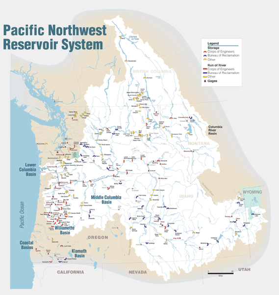
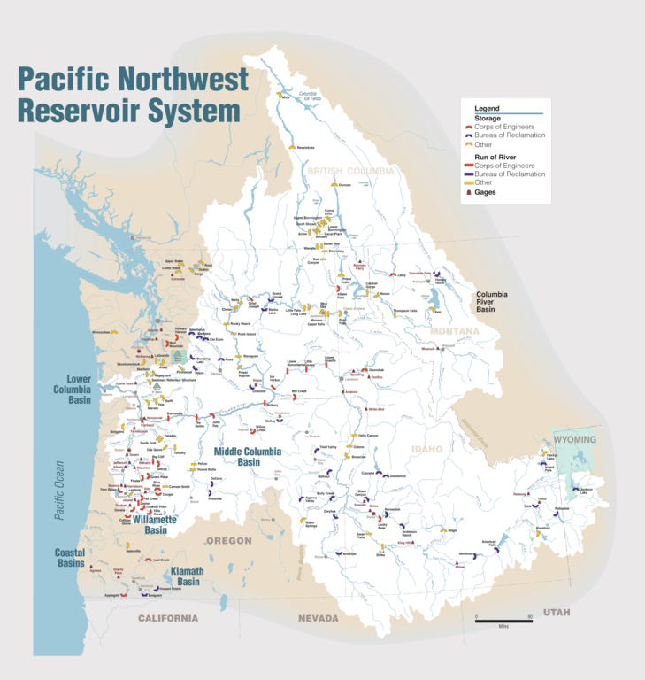
English: Maps of dams, drainage and estuaries along the Columbia River in North America (USA, Canada). Original caption: The Columbia River carved the Interior Columbia River Basin from the landscape of seven Western states and two Canadian provinces. The river itself flows from its headwaters in British Columbia, Canada through only two states, forming part of the Washington-Oregon border, the vast Interior Columbia River Basin is defined by the area drained by the river and its many tributaries. This 58-million-hectare area (about the size of France) extends roughly from the crest of the Cascade Mountains of Oregon and Washington east through Idaho to the Continental Divide in the Rocky Mountains of Montana and Wyoming, and from the headwaters of the Columbia River in Canada to the high desert of northern Nevada and northwestern Utah. |
| Dato | |
| Kilde | Portland District Visual Information, U.S. Army Corps of Engineers |
| Opphavsperson | U.S. Army Corps of Engineers |
| Andre versjoner |
Derivative works of this file: Columbia.png |
Lisensiering
This image or file is a work of a U.S. Army Corps of Engineers soldier or employee, taken or made as part of that person's official duties. As a work of the U.S. federal government, the image is in the public domain.
|
Filhistorikk
Klikk på et tidspunkt for å vise filen slik den var på det tidspunktet.
| Dato/klokkeslett | Miniatyrbilde | Dimensjoner | Bruker | Kommentar | |
|---|---|---|---|---|---|
| nåværende | 12. jan. 2010 kl. 00:31 | | 1 930 × 2 032 (412 KB) | Spankston | larger file, higher resolution |
| 11. jan. 2010 kl. 23:56 |  | 914 × 963 (565 KB) | Spankston | {{Information |Description={{en|1=Maps of dams, drainage and estuaries along the Columbia River in North America (USA, Canada). Original caption: The Columbia River carved the Interior Columbia River Basin from the landscape of seven Western states a |
Filbruk
De følgende 15 sidene bruker denne filen:
- Boundary-demningen
- Chief Joseph-demningen
- Dalles-demningen
- Grand Coulee-demningen
- Hungry Horse-demningen
- John Day-demningen
- Lake Chelan-demningen
- Little Goose-demningen
- Lower Granite-demningen
- Lower Monumental-demningen
- Priest Rapids-demningen
- Rock Island-demningen
- Rocky Reach-demningen
- Wanapum-demningen
- Wells-demningen
Global filbruk
Følgende andre wikier bruker denne filen:
- Bruk i bg.wikipedia.org
- Bruk i de.wikipedia.org
- Bruk i en.wikipedia.org
- Rocky Reach Dam
- Rock Island Dam
- Wanapum Dam
- Priest Rapids Dam
- Bonneville Dam
- Salmon River (Idaho)
- List of rivers of Washington (state)
- List of dams in the Columbia River watershed
- Revelstoke Dam
- The Dalles Dam
- Keenleyside Dam
- Columbia River Treaty
- Little Goose Dam
- Lower Granite Dam
- Lower Monumental Dam
- Ice Harbor Dam
- Dworshak Dam
- Palisades Dam
- Hells Canyon Dam
- Oxbow Dam
- Brownlee Dam
- Jackson Lake Dam
- C. J. Strike Dam
- Lake Cascade
- Deadwood Reservoir
- Lucky Peak Dam
- Arrowrock Dam
- Anderson Ranch Dam
- Zosel Dam
- User:Mdmunabbir/sandbox
- Bruk i fi.wikipedia.org
- Bruk i fr.wikipedia.org
- Bruk i fy.wikipedia.org
- Bruk i he.wikipedia.org
- Bruk i it.wikipedia.org
- Bruk i nl.wikipedia.org
- Bruk i ro.wikipedia.org
- Bruk i ru.wikipedia.org
- Bruk i vec.wikipedia.org