Fil:MountSidleyWaescheMap.jpg

Størrelse på denne forhåndsvisningen: 750 × 600 piksler. Andre oppløsninger: 300 × 240 piksler | 600 × 480 piksler | 1 000 × 800 piksler.
Opprinnelig fil (1 000 × 800 piksler, filstørrelse: 181 KB, MIME-type: image/jpeg)
| Denne filen er fra Wikimedia Commons og kan brukes av andre prosjekter. Informasjonen fra filbeskrivelsessiden vises nedenfor. |
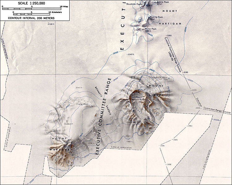
Topographic map of Mounts Sidley and Waesche (1:250,000 scale)
Source: http://usarc.usgs.gov/antarctic_atlas/ USGS Atlas of Antarctic Research
This image is in the public domain in the United States because it only contains materials that originally came from the United States Geological Survey, an agency of the United States Department of the Interior. For more information, see the official USGS copyright policy.
|
Filhistorikk
Klikk på et tidspunkt for å vise filen slik den var på det tidspunktet.
| Dato/klokkeslett | Miniatyrbilde | Dimensjoner | Bruker | Kommentar | |
|---|---|---|---|---|---|
| nåværende | 16. jan. 2005 kl. 02:51 | | 1 000 × 800 (181 KB) | GarciaB~commonswiki | Topographic map of Mounts Sidley and Waesche (1:250,000 scale) |
Filbruk
De følgende 2 sidene bruker denne filen:
Global filbruk
Følgende andre wikier bruker denne filen:
- Bruk i ar.wikipedia.org
- Bruk i ast.wikipedia.org
- Bruk i bg.wikipedia.org
- Bruk i bs.wikipedia.org
- Bruk i ceb.wikipedia.org
- Bruk i de.wikipedia.org
- Bruk i en.wikipedia.org
- Bruk i es.wikipedia.org
- Bruk i fr.wikipedia.org
- Bruk i ja.wikipedia.org
- Bruk i lld.wikipedia.org
- Bruk i nn.wikipedia.org
- Bruk i pl.wikipedia.org
- Bruk i ru.wikipedia.org
- Bruk i sv.wikipedia.org
- Bruk i tr.wikipedia.org
- Bruk i uk.wikipedia.org
- Bruk i www.wikidata.org
- Bruk i zh.wikipedia.org