Fil:MapaMacau1912.jpg
Størrelse på denne forhåndsvisningen: 416 × 599 piksler. Andre oppløsninger: 167 × 240 piksler | 631 × 908 piksler.
Opprinnelig fil (631 × 908 piksler, filstørrelse: 81 KB, MIME-type: image/jpeg)
| Denne filen er fra Wikimedia Commons og kan brukes av andre prosjekter. Informasjonen fra filbeskrivelsessiden vises nedenfor. |
Beskrivelse
| Beskrivelse |
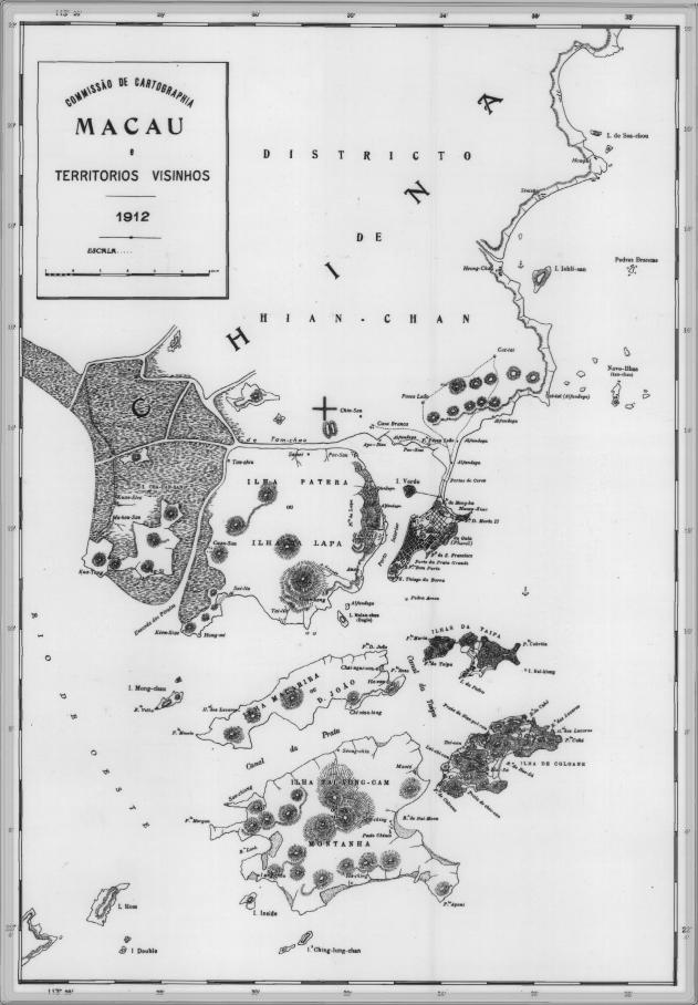
English: This is a map of Macau and is surrounded territories in 1912. In that time, the Portuguese Colony of Macau is formed by the Peninsula de Macau, Taipa and Coloane islands. Macau also have a great influence on the islands of Lapa, D. João and Montanha, located on the west of the Portuguese Colony of Macau. See here for original color version. |
| Dato | |
| Kilde | |
| Opphavsperson |
Lisensiering
This work is from an official work of Macau and is in the public domain in Macau and possibly other jurisdictions. See here for the type of material that are in the Public domain in Chinese and Portuguese (official languages of Macau), plus English (not an official language of Macau).
|
 | |
| Annotations | This image is annotated: View the annotations at Commons |
Filhistorikk
Klikk på et tidspunkt for å vise filen slik den var på det tidspunktet.
| Dato/klokkeslett | Miniatyrbilde | Dimensjoner | Bruker | Kommentar | |
|---|---|---|---|---|---|
| nåværende | 14. feb. 2007 kl. 11:34 | | 631 × 908 (81 KB) | AdriAg | This is a map of Macau and is surrounded territories in 1912. In that time, the Portuguese Colony of Macau is formed by the [http://pt.wikipedia.org/wiki/Pen%C3%ADnsula_de_Macau Peninsula de Macau], [http://pt.wikipedia.org/wiki/Taipa Taipa] and [http://p |
Filbruk
Den følgende siden bruker denne filen:
Global filbruk
Følgende andre wikier bruker denne filen:
- Bruk i en.wikipedia.org
- Bruk i es.wikipedia.org
- Bruk i fa.wikipedia.org
- Bruk i fr.wikipedia.org
- Bruk i it.wikipedia.org
- Bruk i ja.wikipedia.org
- Bruk i mwl.wikipedia.org
- Bruk i nl.wikipedia.org
- Bruk i pt.wikipedia.org
- Bruk i ru.wikipedia.org
- Bruk i ur.wikipedia.org
- Bruk i zh.wikipedia.org