Fil:Lunda Empire.png

Størrelse på denne forhåndsvisningen: 487 × 599 piksler. Andre oppløsninger: 195 × 240 piksler | 578 × 711 piksler.
Opprinnelig fil (578 × 711 piksler, filstørrelse: 115 KB, MIME-type: image/png)
| Denne filen er fra Wikimedia Commons og kan brukes av andre prosjekter. Informasjonen fra filbeskrivelsessiden vises nedenfor. |
Beskrivelse
| Beskrivelse |
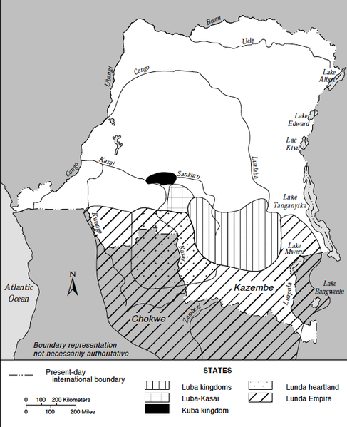
English: Map of Major States in the Southern Savannas, Mid-Nineteenth Century. Based on information from Jan Vansina, Kingdoms of the Savanna, Madison, 1968. The map includes the Lunda Empire (with the Lunda heartland), the Luba kingdoms, the Luba-Kasai and the Kuba kingdom as they were thought to have been around 1850. Ελληνικά: Χάρτης της Αυτοκρατορίας Λούντα |
| Dato | |
| Kilde | Zaire : a country study (1994) |
| Opphavsperson | Library of Congress |
| Andre versjoner |
|

Lisensiering
This work is in the public domain in the United States because it is a work prepared by an officer or employee of the United States Government as part of that person’s official duties under the terms of Title 17, Chapter 1, Section 105 of the US Code.
Note: This only applies to original works of the Federal Government and not to the work of any individual U.S. state, territory, commonwealth, county, municipality, or any other subdivision. This template also does not apply to postage stamp designs published by the United States Postal Service since 1978. (See § 313.6(C)(1) of Compendium of U.S. Copyright Office Practices). It also does not apply to certain US coins; see The US Mint Terms of Use.
|
 | |
| Denne filen har blitt identifisert til å være fri for kjente restriksjoner under lov om opphavsrett, inkludert alle relaterte og nærstående rettigheter. | ||
Filhistorikk
Klikk på et tidspunkt for å vise filen slik den var på det tidspunktet.
| Dato/klokkeslett | Miniatyrbilde | Dimensjoner | Bruker | Kommentar | |
|---|---|---|---|---|---|
| nåværende | 13. jan. 2015 kl. 15:27 | | 578 × 711 (115 KB) | Monopoly31121993 | User created page with UploadWizard |
Filbruk
Den følgende siden bruker denne filen:
Global filbruk
Følgende andre wikier bruker denne filen:
- Bruk i ast.wikipedia.org
- Bruk i ca.wikipedia.org
- Bruk i de.wikipedia.org
- Bruk i en.wikipedia.org
- Bruk i es.wikipedia.org
- Bruk i fa.wikipedia.org
- Bruk i fi.wikipedia.org
- Bruk i fr.wikipedia.org
- Bruk i ha.wikipedia.org
- Bruk i it.wikipedia.org
- Bruk i ru.wikipedia.org
- Bruk i sv.wikipedia.org
- Bruk i tum.wikipedia.org
- Bruk i uk.wikipedia.org
- Bruk i www.wikidata.org