Fil:La palma volcano-close.jpg

Størrelse på denne forhåndsvisningen: 800 × 528 piksler. Andre oppløsninger: 320 × 211 piksler | 640 × 423 piksler | 1 024 × 676 piksler | 1 280 × 845 piksler | 3 022 × 1 996 piksler.
Opprinnelig fil (3 022 × 1 996 piksler, filstørrelse: 922 KB, MIME-type: image/jpeg)
| Denne filen er fra Wikimedia Commons og kan brukes av andre prosjekter. Informasjonen fra filbeskrivelsessiden vises nedenfor. |
Beskrivelse
| Beskrivelse |
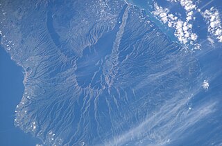
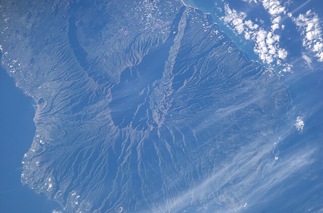
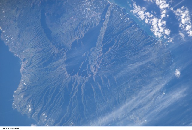
English: Satellite photo of Caldera de Taburiente and Cumbre Vieja, La Palma, Canary Islands. (South is above, North below.) Volcano, close up |
| Dato | |
| Kilde | JSC Gateway to Astronaut Photography of Earth |
| Opphavsperson | Earth Science and Remote Sensing Unit, Lyndon B. Johnson Space Center |
| Andre versjoner |
http://eol.jsc.nasa.gov/DatabaseImages/ESC/small/ISS006/ISS006-E-9561.JPG |
| Mission | ISS006 |
| Roll | E |
| Frame | 9561 |
| Geographic area | the Canary Islands |
| Features | LA PALMA ISLAND, CENTRAL |
| Cloud percentage | 10% |
| Altitude | 211 nautical miles (391 km) |
| Look angle | 27° |
| Look direction | SE |
| Sun Azimuth | 133° |
| Sun Elevation | 19° |
| Camera | Kodak DCS760c Electronic Still Camera |
| Focal length | 400 mm |
| Objektposisjon | | Dette og andre bilder på denne posisjonen på: OpenStreetMap |
|---|
| Kameraposisjon | | Dette og andre bilder på denne posisjonen på: OpenStreetMap |
|---|
This image or video was catalogued by Johnson Space Center of the United States National Aeronautics and Space Administration (NASA) under Photo ID: ISS006-E-09561. This tag does not indicate the copyright status of the attached work. A normal copyright tag is still required. See Commons:Licensing. Other languages:
|
Lisensiering
| This file is in the public domain in the United States because it was solely created by NASA. NASA copyright policy states that "NASA material is not protected by copyright unless noted". (See Template:PD-USGov, NASA copyright policy page or JPL Image Use Policy.) | ||
 |
Warnings:
|
Filhistorikk
Klikk på et tidspunkt for å vise filen slik den var på det tidspunktet.
| Dato/klokkeslett | Miniatyrbilde | Dimensjoner | Bruker | Kommentar | |
|---|---|---|---|---|---|
| nåværende | 7. mar. 2020 kl. 16:45 | | 3 022 × 1 996 (922 KB) | Lojwe | Cropped < 1 % horizontally, 3 % vertically using CropTool with precise mode. |
| 13. okt. 2015 kl. 04:26 |  | 3 032 × 2 064 (943 KB) | Xb2u7Zjzc32 | ISS006-E-09561 3032 x 2064 pixels | |
| 17. mar. 2008 kl. 11:39 |  | 639 × 422 (61 KB) | Mbdortmund | ||
| 30. des. 2004 kl. 07:15 |  | 639 × 435 (70 KB) | Clngre~commonswiki | Satellite photo of Cumbre Vieja, La Palma, Canary Islands. Volcano, close up {{PD-USGov-NASA}} |
Filbruk
Den følgende siden bruker denne filen:
Global filbruk
Følgende andre wikier bruker denne filen:
- Bruk i ca.wikipedia.org
- Bruk i cs.wikipedia.org
- Bruk i da.wikipedia.org
- Bruk i de.wikipedia.org
- Bruk i en.wikipedia.org
- Bruk i es.wikipedia.org
- Bruk i fr.wikipedia.org
- Bruk i it.wikipedia.org
- Bruk i ko.wikipedia.org
- Bruk i nn.wikipedia.org
- Bruk i oc.wikipedia.org
- Bruk i pt.wikipedia.org
- Bruk i ru.wikipedia.org
- Bruk i simple.wikipedia.org
- Bruk i sk.wikipedia.org
- Bruk i sv.wikipedia.org
- Bruk i uk.wikipedia.org
- Bruk i www.wikidata.org