Fil:Karte Haus Burgund 4 EN.png
Størrelse på denne forhåndsvisningen: 426 × 600 piksler. Andre oppløsninger: 170 × 240 piksler | 341 × 480 piksler | 545 × 768 piksler | 727 × 1 024 piksler | 2 500 × 3 521 piksler.
Opprinnelig fil (2 500 × 3 521 piksler, filstørrelse: 1,33 MB, MIME-type: image/png)
| Denne filen er fra Wikimedia Commons og kan brukes av andre prosjekter. Informasjonen fra filbeskrivelsessiden vises nedenfor. |
| Beskrivelse |
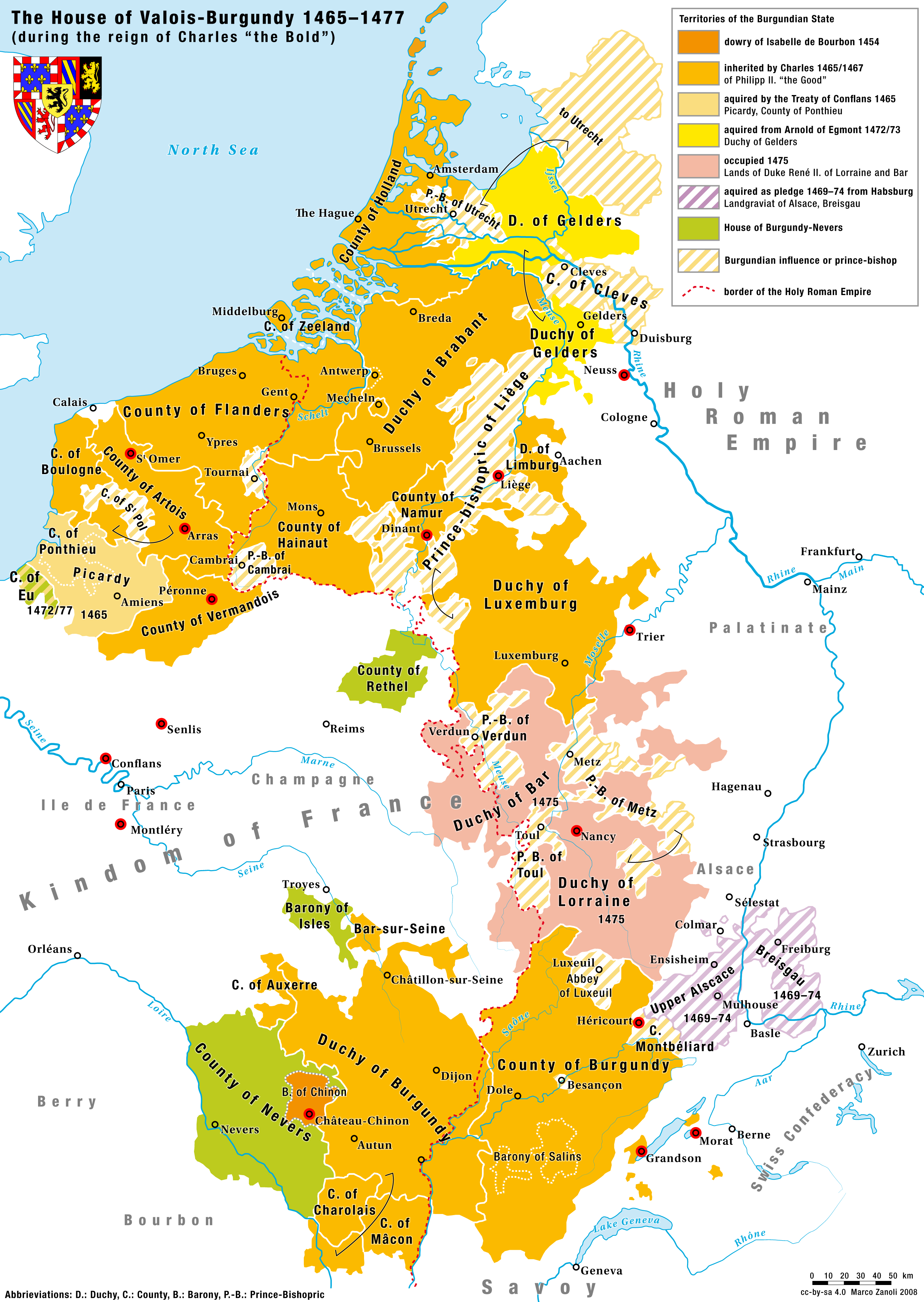
English: Territories of the House of Valois-Burgundy during the reign of Charles the Bold, 1465/67–1477 |
|
| Dato | 2.5.2008 | |
| Kilde | Eget verk | |
| Opphavsperson | Marco Zanoli (sidonius 12:09, 2 May 2008 (UTC)) | |
| Tillatelse (Gjenbruk av denne filen) |
|
|
| Andre versjoner |
Coat of arms from: 
|


-ka.svg)

Filhistorikk
Klikk på et tidspunkt for å vise filen slik den var på det tidspunktet.
| Dato/klokkeslett | Miniatyrbilde | Dimensjoner | Bruker | Kommentar | |
|---|---|---|---|---|---|
| nåværende | 24. aug. 2023 kl. 18:10 | | 2 500 × 3 521 (1,33 MB) | Sidonius | corrected some mistakes and adapted to layout and design of German and French Version |
| 4. jul. 2010 kl. 06:52 |  | 1 200 × 1 690 (652 KB) | DcoetzeeBot | Remove watermark, add author and license data to image metadata, decrease filesize with pngcrush | |
| 17. jun. 2008 kl. 16:04 |  | 1 200 × 1 690 (798 KB) | Sidonius | small corrections, important cities and battles marked with red dot, county of cleves added etc. | |
| 2. mai 2008 kl. 14:09 |  | 1 200 × 1 787 (529 KB) | Sidonius | {{Information |Description={{en|Territories of the House of Valois-Burgundy during the reign of Charles the Bold, 1465/67–1477}} |Source=own work |Date=2.5.2008 |Author=Marco Zanoli (~~~~) |Permission={{Attribution sidonius}} |other_versions=Coat of arm |
Filbruk
Den følgende siden bruker denne filen:
Global filbruk
Følgende andre wikier bruker denne filen:
- Bruk i ar.wikipedia.org
- Bruk i ast.wikipedia.org
- Bruk i azb.wikipedia.org
- Bruk i az.wikipedia.org
- Bruk i be.wikipedia.org
- Bruk i bg.wikipedia.org
- Bruk i ca.wikipedia.org
- Bruk i cs.wikipedia.org
- Bruk i de.wikipedia.org
- Bruk i el.wikipedia.org
- Bruk i en.wikipedia.org
- Bruk i eo.wikipedia.org
- Bruk i es.wikipedia.org
- Bruk i et.wikipedia.org
- Bruk i eu.wikipedia.org
- Bruk i fa.wikipedia.org
- Bruk i fi.wikipedia.org
- Bruk i fr.wikipedia.org
- Bruk i ga.wikipedia.org
- Bruk i gl.wikipedia.org
- Bruk i he.wikipedia.org
- Bruk i hr.wikipedia.org
Vis mer global bruk av denne filen.