Fil:Iceland Mid-Atlantic Ridge map.svg

Størrelse for denne PNG-forhåndsvisningen av denne SVG-filen: 376 × 390 piksler Andre oppløsninger: 231 × 240 piksler | 463 × 480 piksler | 740 × 768 piksler | 987 × 1 024 piksler | 1 974 × 2 048 piksler.
Opprinnelig fil (SVG-fil, standardstørrelse 376 × 390 piksler, filstørrelse: 129 KB)
| Denne filen er fra Wikimedia Commons og kan brukes av andre prosjekter. Informasjonen fra filbeskrivelsessiden vises nedenfor. |
Beskrivelse
| Beskrivelse | |
| Dato | |
| Kilde | http://pubs.usgs.gov/gip/dynamic/understanding.html |
| Opphavsperson | http://pubs.usgs.gov/gip/dynamic/understanding.html |
| Andre versjoner |
|


Lisensiering
This image is in the public domain in the United States because it only contains materials that originally came from the United States Geological Survey, an agency of the United States Department of the Interior. For more information, see the official USGS copyright policy.
|
| Annotations | This image is annotated: View the annotations at Commons |
Filhistorikk
Klikk på et tidspunkt for å vise filen slik den var på det tidspunktet.
| Dato/klokkeslett | Miniatyrbilde | Dimensjoner | Bruker | Kommentar | |
|---|---|---|---|---|---|
| nåværende | 10. jan. 2014 kl. 20:48 | | 376 × 390 (129 KB) | Amitchell125 | text improved |
| 26. feb. 2010 kl. 16:42 |  | 376 × 390 (68 KB) | Beao | Tweak. | |
| 26. feb. 2010 kl. 16:40 |  | 376 × 390 (68 KB) | Beao | Tweak. | |
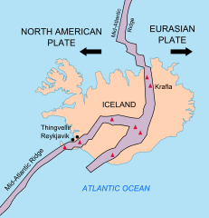
| 26. feb. 2010 kl. 16:37 |  | 376 × 390 (68 KB) | Beao | == Summary == {{Information |Description={{en|1=Map showing the Mid-Atlantic Ridge splitting Iceland and separating the North American and Eurasian Plates. The map also shows Reykjavik, the capital of Iceland, the Thingvellir area, and the locations of so |
Filbruk
De følgende 2 sidene bruker denne filen:
Global filbruk
Følgende andre wikier bruker denne filen:
- Bruk i be-tarask.wikipedia.org
- Bruk i bn.wikipedia.org
- Bruk i ca.wikipedia.org
- Bruk i en.wikipedia.org
- Bruk i en.wikivoyage.org
- Bruk i fi.wikipedia.org
- Bruk i hr.wikipedia.org
- Bruk i id.wikipedia.org
- Bruk i it.wikipedia.org
- Bruk i ko.wikipedia.org
- Bruk i lb.wikipedia.org
- Bruk i nl.wikipedia.org
- Bruk i pl.wikipedia.org
- Bruk i simple.wikipedia.org
- Bruk i sl.wikipedia.org
- Bruk i sr.wikipedia.org
- Bruk i sv.wikipedia.org
- Bruk i tr.wikipedia.org
- Bruk i uk.wikipedia.org
- Bruk i zh.wikipedia.org
- Bruk i zh.wikivoyage.org