Fil:ISS012-E-23598 NASA-Savai'i east end, Apolima strait, Upolu.jpg

Størrelse på denne forhåndsvisningen: 800 × 531 piksler. Andre oppløsninger: 320 × 212 piksler | 640 × 424 piksler | 1 024 × 679 piksler | 1 280 × 849 piksler | 3 040 × 2 016 piksler.
Opprinnelig fil (3 040 × 2 016 piksler, filstørrelse: 1,81 MB, MIME-type: image/jpeg)
| Denne filen er fra Wikimedia Commons og kan brukes av andre prosjekter. Informasjonen fra filbeskrivelsessiden vises nedenfor. |
Beskrivelse
| Beskrivelse |
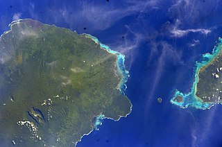
English: East side of Savai'i Island, Apolima, Manono & west end of Upolu |
| Dato | |
| Kilde | Image Science and Analysis Laboratory, NASA-Johnson Space Center. "The Gateway to Astronaut Photography of Earth." <http://eol.jsc.nasa.gov/scripts/sseop/QuickView.pl?directory=ESC&ID=ISS012-E-23598> |
| Opphavsperson | NASA |
| Kameraposisjon | | Dette og andre bilder på denne posisjonen på: OpenStreetMap |
|---|
This image or video was catalogued by Johnson Space Center of the United States National Aeronautics and Space Administration (NASA) under Photo ID: ISS012-E-23598. This tag does not indicate the copyright status of the attached work. A normal copyright tag is still required. See Commons:Licensing. Other languages:
|
Lisensiering
This file is in the public domain in the United States because it was created by the Image Science & Analysis Laboratory, of the NASA Johnson Space Center. NASA copyright policy states that "NASA material is not protected by copyright unless noted". (NASA media use guidelines or Conditions of Use of Astronaut Photographs).
Photo source: ISS012-E-23598.
|
Filhistorikk
Klikk på et tidspunkt for å vise filen slik den var på det tidspunktet.
| Dato/klokkeslett | Miniatyrbilde | Dimensjoner | Bruker | Kommentar | |
|---|---|---|---|---|---|
| nåværende | 18. mai 2013 kl. 15:41 | | 3 040 × 2 016 (1,81 MB) | Ras67 | new rendered from NASA's raw image data |
| 7. aug. 2012 kl. 05:14 |  | 639 × 423 (88 KB) | Ras67 | rotated and cropped from NASA's original | |
| 30. jan. 2010 kl. 15:43 |  | 639 × 435 (62 KB) | Teinesavaii | {{Information |Description={{en|1=East side of Savai'i Island, Apolima, Manono & west end of Upolu}} |Source=Image Science and Analysis Laboratory, NASA-Johnson Space Center. "The Gateway to Astronaut Photography of Earth." <http://eol.jsc.nasa.gov/scri |
Filbruk
Den følgende siden bruker denne filen:
Global filbruk
Følgende andre wikier bruker denne filen:
- Bruk i bn.wikipedia.org
- Bruk i ceb.wikipedia.org
- Bruk i de.wikipedia.org
- Bruk i en.wikipedia.org
- Bruk i es.wikipedia.org
- Bruk i eu.wikipedia.org
- Bruk i id.wikipedia.org
- Bruk i ka.wikipedia.org
- Bruk i mk.wikipedia.org
- Bruk i mrj.wikipedia.org
- Bruk i pl.wikipedia.org
- Bruk i ru.wikipedia.org
- Bruk i sk.wikipedia.org
- Bruk i sm.wikipedia.org
- Bruk i uk.wikipedia.org
- Bruk i ur.wikipedia.org
- Bruk i www.wikidata.org
- Bruk i zh.wikipedia.org