Fil:Europe Köppen Map.png
Størrelse på denne forhåndsvisningen: 800 × 509 piksler. Andre oppløsninger: 320 × 204 piksler | 640 × 407 piksler | 1 024 × 652 piksler | 1 280 × 815 piksler | 1 885 × 1 200 piksler.
Opprinnelig fil (1 885 × 1 200 piksler, filstørrelse: 831 KB, MIME-type: image/png)
| Denne filen er fra Wikimedia Commons og kan brukes av andre prosjekter. Informasjonen fra filbeskrivelsessiden vises nedenfor. |
| Peel, M. C. and Finlayson, B. L. and McMahon, T. A. (2007). "Updated world map of the Köppen-Geiger climate classification". Hydrol. Earth Syst. Sci. 11: 1633-1644. ISSN 1027-5606. |
Legend
Beskrivelse
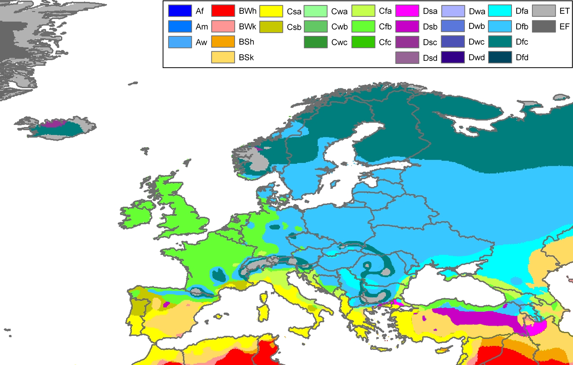
| Beskrivelse | Climate map of Europe (from the "Updated world map of the Köppen-Geiger climate classification"). |
| Dato | |
| Kilde | Hydrology and Earth System Sciences: "Updated world map of the Köppen-Geiger climate classification" (Supplement) - Original file was a JPG-file, this file is has been converted to a PNG-file, without extra modifications, by me (Jeroen). |
| Opphavsperson |
Peel, M. C., Finlayson, B. L., and McMahon, T. A. (University of Melbourne) |
| Tillatelse (Gjenbruk av denne filen) |
|
| Andre versjoner | Derivative works of this file: Köppen Map Europe 01.png |
Related maps
User Jeroenvrp made for these continents and areas a cropped and resized version:
- Africa Köppen Map.png
- Asia Köppen Map.png
- Australia-Oceania Köppen Map.png
- Europe Köppen Map.png
- North America Köppen Map.png
- Russia Köppen Map.png
- South America Köppen Map.png
- West Asia Köppen Map.png.
User LordToran made from the same data these maps:
- Klimagürtel-der-erde-eisklima.png
- Klimagürtel-der-erde-gemäßigte-zone.png
- Klimagürtel-der-erde-polargebiete.png
- Klimagürtel-der-erde-subtropen.png
- Klimagürtel-der-erde-tropen.png
- Klimagürtel-der-erde-tundra.png
- Klimagürtel-der-erde-warmgemäßigte-zone.png
- Klimagürtel-der-erde.png
- Klimagürtel-der-erde.svg
- Klimate-humidität.png
- Köppen-geiger-hessd-2007.svg
- Köppen-vereinfacht.svg
- Trockenklimate.png
Lisensiering
Denne filen er lisensiert under lisensen Creative Commons Navngivelse-DelPåSammeVilkår 3.0 Unported
- Du står fritt:
- til å dele – til å kopiere, distribuere og overføre verket
- til å blande – til å endre verket
- Under de følgende betingelsene:
- navngivelse – Du må kreditere verket på passende vis, lenke til lisensen og indikere hvorvidt det har blitt gjort endringer. Du kan gjøre det på enhver rimelig måte, men ikke på en måte som antyder at lisensgiveren støtter deg eller din bruk av verket.
- del på samme vilkår – Dersom du remikser, omarbeider eller på annen måte bygger på dette verket, må du kun distribuere resultatet under den samme eller en samsvarende lisens som denne.
Filhistorikk
Klikk på et tidspunkt for å vise filen slik den var på det tidspunktet.
| Dato/klokkeslett | Miniatyrbilde | Dimensjoner | Bruker | Kommentar | |
|---|---|---|---|---|---|
| nåværende | 23. nov. 2017 kl. 00:30 | | 1 885 × 1 200 (831 KB) | Mélomène | Cantabrian Asturian, Pyrenean, Alps, Carpathian Mts formed ranges. |
| 13. mar. 2011 kl. 14:18 |  | 1 885 × 1 200 (957 KB) | Maphobbyist | Painted the Caspian Sea as white as it should have been, because the Köppen system is based on the concept that climate types are correlated with the natural vegetation. Thus with Köppen, climate zone boundaries have been selected with vegetation distri | |
| 13. okt. 2007 kl. 00:59 |  | 1 885 × 1 200 (868 KB) | Jeroen | Citation: '''Peel, M. C., Finlayson, B. L., and McMahon, T. A.: Updated world map of the Köppen-Geiger climate classification, Hydrol. Earth Syst. Sci., 11, 1633-1644, 2007.''' {{Information |Description= Climate map of Europe (from the "[[:Image:Worl |
Filbruk
Det er ingen sider som bruker denne filen.
Global filbruk
Følgende andre wikier bruker denne filen:
- Bruk i cs.wikipedia.org
- Bruk i da.wikipedia.org
- Bruk i de.wikipedia.org
- Bruk i en.wikipedia.org
- Bruk i eo.wikipedia.org
- Bruk i es.wikipedia.org
- Bruk i es.wikibooks.org
- Bruk i fr.wikipedia.org
- Bruk i fy.wikipedia.org
- Bruk i hi.wikipedia.org
- Bruk i hu.wikipedia.org
- Bruk i ja.wikipedia.org
- Bruk i ka.wikipedia.org
- Bruk i kk.wikipedia.org
- Bruk i mk.wikipedia.org
- Bruk i nl.wikipedia.org
- Bruk i pt.wikipedia.org
- Bruk i ru.wikipedia.org
- Bruk i sl.wikipedia.org
- Bruk i sr.wikipedia.org
- Bruk i th.wikipedia.org
- Bruk i tr.wikipedia.org