Fil:EasternRomanEmpire.png
Ingen høyere oppløsning tilgjengelig.
EasternRomanEmpire.png (250 × 175 piksler, filstørrelse: 7 KB, MIME-type: image/png)
| Denne filen er fra Wikimedia Commons og kan brukes av andre prosjekter. Informasjonen fra filbeskrivelsessiden vises nedenfor. |

|
This map has been uploaded by Electionworld from en.wikipedia.org to enable the |

|
The copyright holder of this work allows anyone to use it for any purpose including unrestricted redistribution, commercial use, and modification.
|
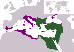
The territory in green represents the core areas held by the Eastern Roman Empire before the Muslim conquests The territory in purple represents the greatest extent of the Byzantine Empire under Emperor Justinian I
Filhistorikk
Klikk på et tidspunkt for å vise filen slik den var på det tidspunktet.
| Dato/klokkeslett | Miniatyrbilde | Dimensjoner | Bruker | Kommentar | |
|---|---|---|---|---|---|
| nåværende | 13. des. 2006 kl. 20:27 | | 250 × 175 (7 KB) | Electionworld | {{ew|en|24630}} {{CopyrightedFreeUse-User|24630}} The territory in green represents the core areas held by the Eastern Roman Empire before the Muslim conquests The territory in purple represents the greatest extent of the Byzantine Empire unde |
Filbruk
Den følgende siden bruker denne filen:
Global filbruk
Følgende andre wikier bruker denne filen:
- Bruk i da.wikipedia.org
- Bruk i en.wiktionary.org
- Bruk i gd.wikipedia.org
- Bruk i lv.wikipedia.org
- Bruk i ru.wiktionary.org
- Bruk i sl.wikipedia.org
- Bruk i sq.wikipedia.org
- Bruk i sv.wikipedia.org
- Bruk i vi.wikipedia.org
- Bruk i zh.wiktionary.org