Fil:Debris-GEO1280.jpg

Opprinnelig fil (1 280 × 1 024 piksler, filstørrelse: 125 KB, MIME-type: image/jpeg)
| Denne filen er fra Wikimedia Commons og kan brukes av andre prosjekter. Informasjonen fra filbeskrivelsessiden vises nedenfor. |
| Beskrivelse |
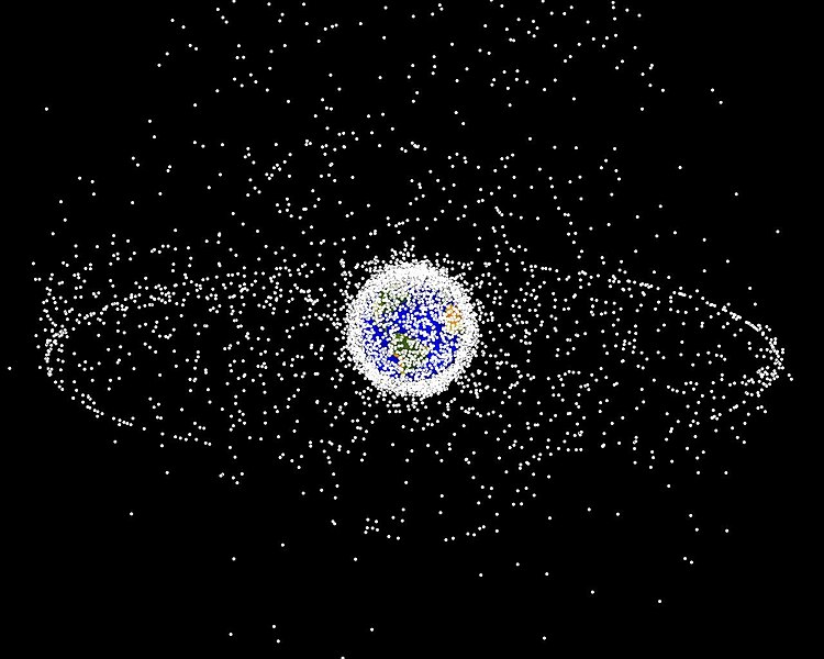
English: Debris plot by NASA.
A computer-generated image of objects in Earth orbit that are currently being tracked. Approximately 95% of the objects in this illustration are orbital debris, i.e., not functional satellites. The dots represent the current location of each item. The orbital debris dots are scaled according to the image size of the graphic to optimize their visibility and are not scaled to Earth. The image provides a good visualization of where the greatest orbital debris populations exist. This image is generated from a distant oblique vantage point to provide a good view of the object population in the geosynchronous region (around 35,785 km altitude). Note the larger population of objects over the northern hemisphere is due mostly to Russian objects in high-inclination, high-eccentricity orbits. |
|||||
| Kilde | NASA Orbital Debris Program Office, photo gallery | |||||
| Opphavsperson | NASA image | |||||
| Tillatelse (Gjenbruk av denne filen) |
|


Filhistorikk
Klikk på et tidspunkt for å vise filen slik den var på det tidspunktet.
| Dato/klokkeslett | Miniatyrbilde | Dimensjoner | Bruker | Kommentar | |
|---|---|---|---|---|---|
| nåværende | 1. feb. 2005 kl. 18:45 | | 1 280 × 1 024 (125 KB) | Srbauer | debris plot by NASA |
Filbruk
Den følgende siden bruker denne filen:
Global filbruk
Følgende andre wikier bruker denne filen:
- Bruk i af.wikipedia.org
- Bruk i an.wikipedia.org
- Bruk i ar.wikipedia.org
- Bruk i az.wikipedia.org
- Bruk i be-tarask.wikipedia.org
- Bruk i be.wikipedia.org
- Bruk i bn.wikipedia.org
- Bruk i ca.wikipedia.org
- Bruk i cs.wikipedia.org
- Bruk i da.wikipedia.org
- Bruk i de.wikipedia.org
- Bruk i de.wiktionary.org
- Bruk i el.wikipedia.org
- Bruk i en.wikipedia.org
- Earth
- International Space Station
- Geosynchronous orbit
- Geostationary orbit
- Envisat
- Outer space
- Talk:Geostationary orbit
- Planetes
- Kessler syndrome
- Portal:Outer space
- Spacecraft cemetery
- Catcher's Mitt
- Human presence in space
- User talk:Penyulap/staticEnglish
- Space Surveillance Telescope
- User:Ginnybarnes/Spacecraft cemetery
- Portal:World
- User:FreshYoMama/TWA/Earth
- User:FreshYoMama/TWA/Earth/2
- User:Mumuhuohuo
- Draft:Space Congestion
- Bruk i en.wikinews.org
- Bruk i eo.wikipedia.org
- Bruk i es.wikipedia.org
Vis mer global bruk av denne filen.