Fil:CQA Four Mile Bridge.jpg
Størrelse på denne forhåndsvisningen: 753 × 600 piksler. Andre oppløsninger: 301 × 240 piksler | 603 × 480 piksler | 964 × 768 piksler | 1 280 × 1 020 piksler | 2 560 × 2 039 piksler | 4 624 × 3 683 piksler.
Opprinnelig fil (4 624 × 3 683 piksler, filstørrelse: 1,88 MB, MIME-type: image/jpeg)
| Denne filen er fra Wikimedia Commons og kan brukes av andre prosjekter. Informasjonen fra filbeskrivelsessiden vises nedenfor. |
|
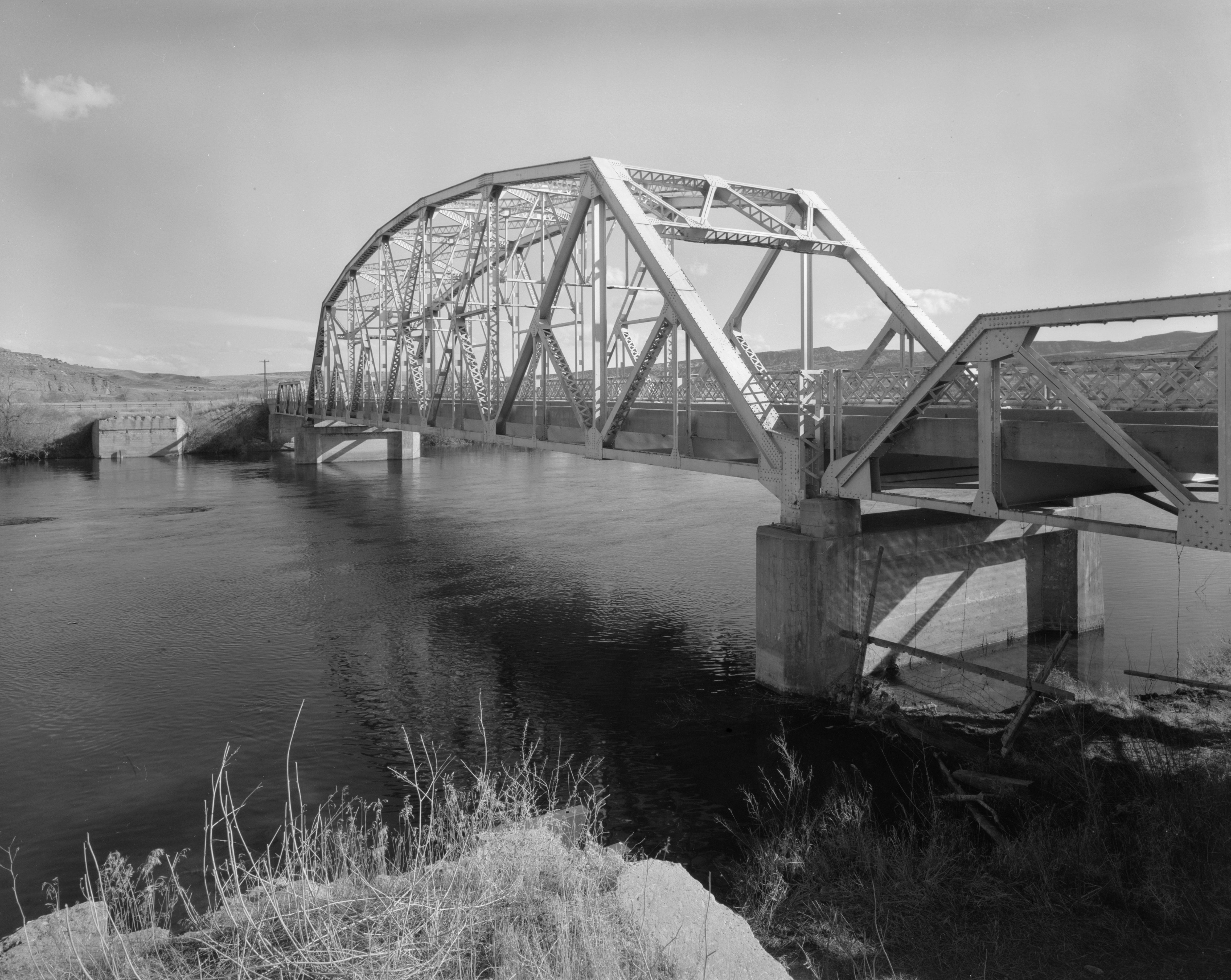
This is an image of a place or building that is listed on the National Register of Historic Places in the United States of America. Its reference number is 85000423. |
| Kameraposisjon | | Dette og andre bilder på denne posisjonen på: OpenStreetMap |
|---|
| Beskrivelse |
English: Eastern side of the CQA Four Mile Bridge, which carries WYO 173 over the Bighorn River near Thermopolis in Hot Springs County, Wyoming, United States. Built in 1927, this Pennsylvania through truss bridge is listed on the National Register of Historic Places. |
||||
| Dato | |||||
| Kilde |
Library of Congress, Prints and Photograph Division HAER: WYO,9-THERM.V,2-1
|
||||
| Opphavsperson | Clayton B. Fraser | ||||
| Tillatelse (Gjenbruk av denne filen) |
|

Filhistorikk
Klikk på et tidspunkt for å vise filen slik den var på det tidspunktet.
| Dato/klokkeslett | Miniatyrbilde | Dimensjoner | Bruker | Kommentar | |
|---|---|---|---|---|---|
| nåværende | 27. apr. 2009 kl. 18:14 | | 4 624 × 3 683 (1,88 MB) | Martin H. | high res; cropped |
| 25. apr. 2009 kl. 17:18 |  | 1 024 × 820 (170 KB) | Nyttend | {{Location|43|36|13|N|108|11|48|W}} {{Information |Description={{en|Eastern side of the {{w|CQA Four Mile Bridge}}, which carries {{w|Wyoming Highway 173|WYO 173}} over the {{w|Bighorn River}} near {{w|Thermopolis, Wyoming|Thermopolis}} in {{w|Hot Springs |
Filbruk
Den følgende siden bruker denne filen:
Global filbruk
Følgende andre wikier bruker denne filen:
- Bruk i arz.wikipedia.org
- Bruk i ca.wikipedia.org
- Bruk i ceb.wikipedia.org
- Bruk i da.wikipedia.org
- Bruk i de.wikipedia.org
- Bruk i en.wikipedia.org
- Bruk i sv.wikipedia.org
- Bruk i www.wikidata.org
- Bruk i xmf.wikipedia.org