Fil:Andreanof Map.jpg
Ingen høyere oppløsning tilgjengelig.
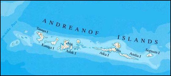
Andreanof_Map.jpg (560 × 249 piksler, filstørrelse: 24 KB, MIME-type: image/jpeg)
| Denne filen er fra Wikimedia Commons og kan brukes av andre prosjekter. Informasjonen fra filbeskrivelsessiden vises nedenfor. |
Beskrivelse
| Beskrivelse |
Deutsch: Karte der Andreanof Islands, Alaska |
| Dato | |
| Kilde | http://www.lib.utexas.edu/maps/united_states/united_states_wall_2002_ak.jpg, cropepd |
| Opphavsperson | nationalatlas.gov/U.S. Geological Survey, edited by Ulrich Kaden |
Lisensiering
This image is in the public domain in the United States because it only contains materials that originally came from the United States Geological Survey, an agency of the United States Department of the Interior. For more information, see the official USGS copyright policy.
|
Filhistorikk
Klikk på et tidspunkt for å vise filen slik den var på det tidspunktet.
| Dato/klokkeslett | Miniatyrbilde | Dimensjoner | Bruker | Kommentar | |
|---|---|---|---|---|---|
| nåværende | 13. feb. 2009 kl. 17:37 | | 560 × 249 (24 KB) | Ulrich Kaden | {{Information |Description={{en|1=Map of the Andreanof Islands}} {{de|1=Karte der Andreanof Islands}} |Source=http://www.lib.utexas.edu/maps/united_states/united_states_wall_2002_ak.jpg |Author=University of Texas / Own Work |Date=2009 |Permission= |other |
Filbruk
Den følgende siden bruker denne filen:
Global filbruk
Følgende andre wikier bruker denne filen:
- Bruk i ar.wikipedia.org
- Bruk i ast.wikipedia.org
- Bruk i be.wikipedia.org
- Bruk i ca.wikipedia.org
- Bruk i ceb.wikipedia.org
- Bruk i de.wikipedia.org
- Bruk i el.wikipedia.org
- Bruk i en.wikipedia.org
- Bruk i es.wikipedia.org
- Bruk i fi.wikipedia.org
- Bruk i gl.wikipedia.org
- Bruk i incubator.wikimedia.org
- Bruk i it.wikipedia.org
- Bruk i ka.wikipedia.org
- Bruk i ko.wikipedia.org
- Bruk i uk.wikipedia.org
- Bruk i www.wikidata.org
- Bruk i zh.wikipedia.org