Fil:America noviter delineata.jpg
Opprinnelig fil(5 965 × 4 528 piksler, filstørrelse: 5,17 MB, MIME-type: image/jpeg)


Wikimedia Commons' logo

Beskrivelse

Beskrivelse
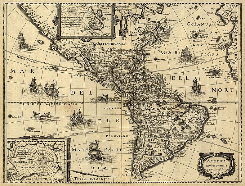
Latina: America noviter delineata / auct. Jodoco Hondio; H. Picard fecit.
English: America newly delineated / by Jodocus Hondius; engraved by H. Picard. A 17th-century map of the Americas. Scale ca. 1:45,000,000. Map ranges from W 125°–W 5° and N 70°–S 60°. Also includes insets of the polar regions.
Français : L'amérique nouvellement cartographiée / Par Jocodus Hondius; gravé par H. Picard. Une carte des amériques du XVIIe siècle. Echelle: environ 1:45 000 000. La carte couvre un espace allant de 5°W à 125°W et de 60°S à 70°N. Elle inclut aussi en encarts les régions polaires.
Kilde

Published by Jean Boisseau. The U.S. Library of Congress gives the date of publication as "1640?", while another source suggests a first publication of 1637 or 1639. Digital version produced by the U.S. Library of Congress Geography and Map Division. JPEG 2000 source image converted to JPEG by User:Delirium using JasPer 1.701.0, since JPEG 2000 is not as of this uploading supported on Commons.

This map is available from the United States Library of Congress's Geography & Map Division
under the digital ID g3290.np000144.
This tag does not indicate the copyright status of the attached work. A normal copyright tag is still required. See Commons:Licensing.

العربية  беларуская (тарашкевіца)  বাংলা  čeština  Deutsch  English  español  فارسی  suomi  français  galego  עברית  magyar  Bahasa Indonesia  italiano  日本語  lietuvių  македонски  മലയാളം  Nederlands  polski  português  português do Brasil  română  русский  sicilianu  slovenčina  slovenščina  Türkçe  українська  简体中文  繁體中文  +/−

Skaper
Jodocus Hondius (1563-1612)
Tillatelse
(Gjenbruk av denne filen)
This is a faithful photographic reproduction of a two-dimensional, public domain work of art. The work of art itself is in the public domain for the following reason:
Public domain

Dette verket er offentlig eiendom i Norge, EU og land der den opphavsrettslige vernetiden etter opphavsmannens død er 100 år eller kortere. Merk at noen land har lengre vernetid.


For å kunne lagres på Commons må verket både være offentlig eiendom i USA og i opphavslandet. Vernetiden kan i noen tilfeller være lengre enn 80 år i USA, så i tillegg til dette merket trengs det et eget merke som forklarer hvorfor verket er offentlig eiendom (public domain) i USA.
The official position taken by the Wikimedia Foundation is that "faithful reproductions of two-dimensional public domain works of art are public domain".
This photographic reproduction is therefore also considered to be in the public domain in the United States. In other jurisdictions, re-use of this content may be restricted; see Reuse of PD-Art photographs for details.
Georeferering Georeference the map in Wikimaps Warper If inappropriate please set warp_status = skip to hide.


Awards

Bilde of the year
Bilde of the year
Bilde of the day
Bilde of the day
Featured bilde

Wikimedia Commons

Denne filen en kandidat i Årets bilde 2006.
Denne filen var dagens bilde den (en) , 1.
Dette er et utvalgt bilde på Wikimedia Commons (Featured pictures) og er betraktet som et av de beste bildene.
 Med et bildeforhold 4:3 eller 5:4, er dette bildet passende som skrivebordsbakgrunn (se galleri).

Hvis du har et bilde av lignende kvalitet som kan publiserers under en passende lisens, last det opp, merk det, og nominér det.

Bildetekster

Legg til en kort forklaring på hva filen representerer
A 17th-century map of the Americas newly delineated by Jodocus Hondius; engraved by H. Picard.

Elementer som er med i denne fila

motiv

image/jpeg

5ad48d30d4daf7c752e21a8ff169415effca1831

5 422 959 byte

4 528 piksel

5 965 piksel

Filhistorikk

Klikk på et tidspunkt for å vise filen slik den var på det tidspunktet.

Dato/klokkeslettMiniatyrbildeDimensjonerBrukerKommentar
nåværende14. jun. 2006 kl. 08:33Miniatyrbilde av versjonen fra 14. jun. 2006 kl. 08:335 965 × 4 528 (5,17 MB)Delirium''America noviter delineata / auct. Jodoco Hondio; H. Picard fecit.'' (America newly delineated / by Jodoco Hondia; engraved by H. Picard.) A 17th-century map of the Americas. Scale ca. 1:45,000,000. Map ranges from W 125°–W 5° and N 70&d

Den følgende siden bruker denne filen:

Global filbruk

Følgende andre wikier bruker denne filen:

Vis mer global bruk av denne filen.

Metadata