Fil:1814ThompsonMap.jpg
Opprinnelig fil (4 020 × 2 593 piksler, filstørrelse: 3,83 MB, MIME-type: image/jpeg)
| Denne filen er fra Wikimedia Commons og kan brukes av andre prosjekter. Informasjonen fra filbeskrivelsessiden vises nedenfor. |
Beskrivelse
| Beskrivelse |
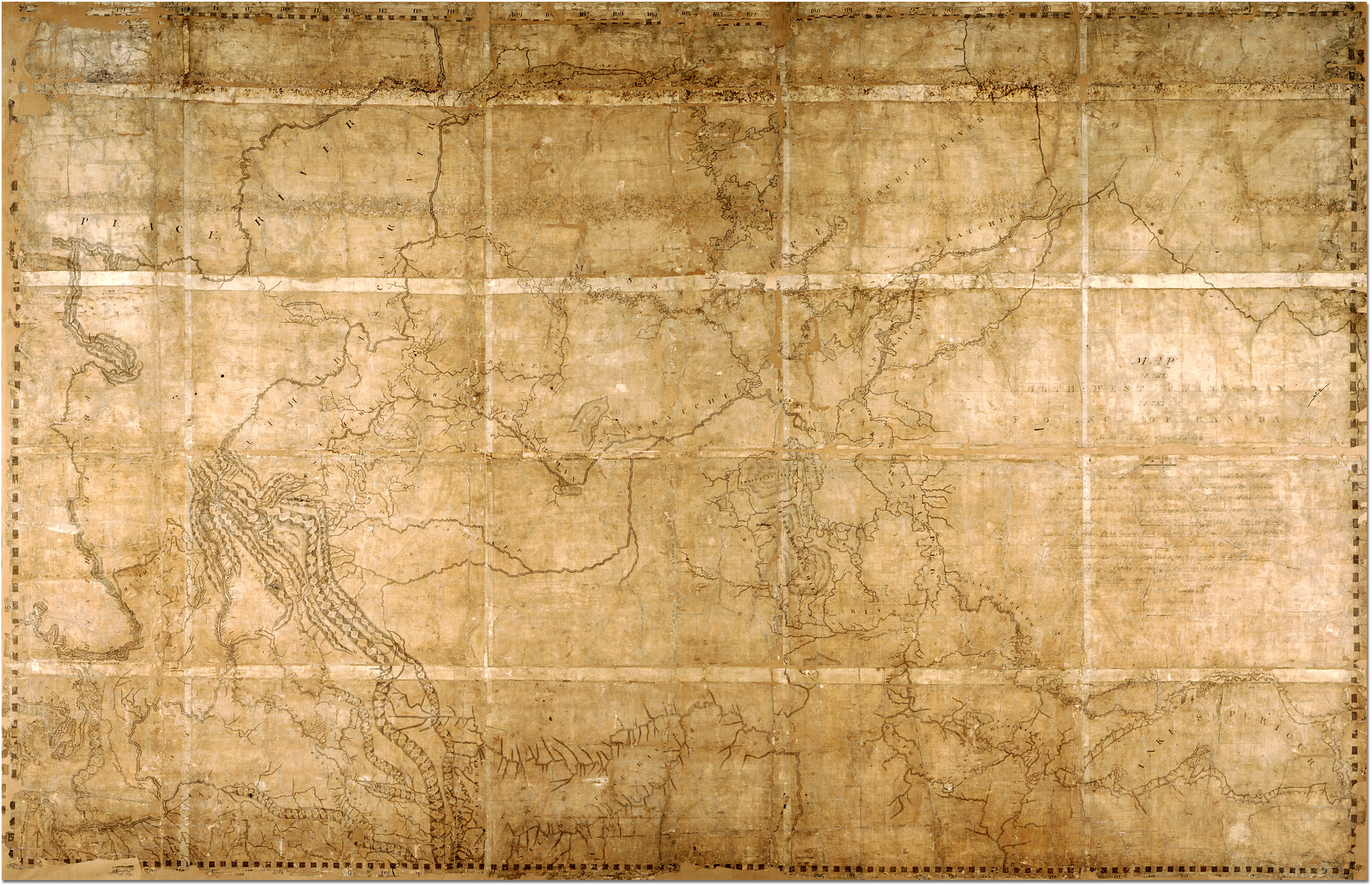
English: Map of the North-West Territory of the Province of Canada by David Thompson, 1814 Archives of Ontario, I0012850 Map is in the public domain. See:http://ao.minisisinc.com/scripts/mwimain.dll/144/ARCH_DESC_FACT/FACTSDESC/REFD%2BF%2B443-6?SESSIONSEARCH Full Title: "Map of the North-West Territory of the Province of Canada from actual Survey during the years 1792-1812. This map made for the North West Company in 1813 and 1814 and delivered to the Honorable William McGillivray then agent Embraces the Region lying between 45 and 60 degrees North Latitude and 84 and 124 degrees West Longitude comprising the Survey's and Discoveries of 20 years namely the Discovery and Survey of the Oregon Territory to the Pacific Ocean the Survey of the Athabasca Lake Slave River and Lake from which flows Mackenzie's River to the Arctic Sea by Mr. Philip Turner the Route of Alexander Mackenzie in 1792 down part of Fraser's river together with the Survey of this River to the Pacific Ocean by the late John Stuart of the North-West Company by David Thompson Astronomer and Surveyor." |
| Dato | mellom 1813 og 1814 |
| Kilde | https://aims.archives.gov.on.ca/scripts/mwimain.dll/144/DESCRIPTION_WEB/WEB_DESC_DET?SESSIONSEARCH&exp=sisn%2013129 |
| Opphavsperson | David Thompson |
Beskrivelse ==

|
This image is available from the Archives of Ontario under the item reference code F 443, R-C(U), AO 1541 This tag does not indicate the copyright status of the attached work. A normal copyright tag is still required. See Commons:Licensing. |
Lisensiering ==
|
Dette verket er offentlig eiendom i Norge, EU og land der den opphavsrettslige vernetiden etter opphavsmannens død er 70 år eller kortere. Merk at noen land har lengre vernetid.
| |
| Denne filen har blitt identifisert til å være fri for kjente restriksjoner under lov om opphavsrett, inkludert alle relaterte og nærstående rettigheter. | |
Filhistorikk
Klikk på et tidspunkt for å vise filen slik den var på det tidspunktet.
| Dato/klokkeslett | Miniatyrbilde | Dimensjoner | Bruker | Kommentar | |
|---|---|---|---|---|---|
| nåværende | 7. feb. 2007 kl. 23:41 | | 4 020 × 2 593 (3,83 MB) | Ccscott~commonswiki | Map of the North-West Territory of the Province of Canada by David Thompson, 1814 Reference Code: F 443, R-C(U), AO 1541 Archives of Ontario, I0012850 Image URL: http://www.archives.gov.on.ca/english/interloan/big/thompson_mapa.htm Map is in the public d |
Filbruk
Den følgende siden bruker denne filen:
Global filbruk
Følgende andre wikier bruker denne filen:
- Bruk i ar.wikipedia.org
- Bruk i ca.wikipedia.org
- Bruk i de.wikipedia.org
- Bruk i en.wikipedia.org
- Bruk i es.wikipedia.org
- Bruk i it.wikipedia.org
- Bruk i ja.wikipedia.org
- Bruk i nl.wikipedia.org
- Bruk i ru.wikipedia.org