Fil:Vancouver1798map-SanJuan-Gulf.png
Størrelse på denne forhåndsvisningen: 521 × 599 piksler. Andre oppløsninger: 209 × 240 piksler | 417 × 480 piksler | 766 × 881 piksler.
Opprinnelig fil (766 × 881 piksler, filstørrelse: 1,39 MB, MIME-type: image/png)
| Denne filen er fra Wikimedia Commons og kan brukes av andre prosjekter. Informasjonen fra filbeskrivelsessiden vises nedenfor. |
Beskrivelse
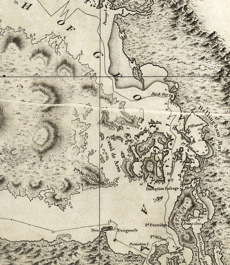
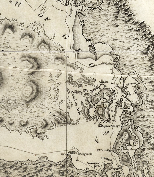
| Beskrivelse | Excerpt of a map by George Vancouver, titled "A chart shewing part of the coast of N.W. America : with the tracks of His Majesty's sloop Discovery and armed tender Chatham / commanded by George Vancouver, Esqr. and prepared under his immediate inspection by Lieut. Joseph Baker..."; published 1798 |
| Dato | |
| Kilde | http://hdl.loc.gov/loc.gmd/g3512c.ct000914 |
| Opphavsperson | George Vancouver; digital version, Library of Congress, Geography and Map Division. |
| Tillatelse (Gjenbruk av denne filen) |
"The Library of Congress is providing access to these materials for educational and research purposes and is not aware of any U.S. copyright protection" (source: [1]) |
Lisensiering
This work is in the public domain in the United States because it is a work prepared by an officer or employee of the United States Government as part of that person’s official duties under the terms of Title 17, Chapter 1, Section 105 of the US Code.
Note: This only applies to original works of the Federal Government and not to the work of any individual U.S. state, territory, commonwealth, county, municipality, or any other subdivision. This template also does not apply to postage stamp designs published by the United States Postal Service since 1978. (See § 313.6(C)(1) of Compendium of U.S. Copyright Office Practices). It also does not apply to certain US coins; see The US Mint Terms of Use.
|
 | |
| Denne filen har blitt identifisert til å være fri for kjente restriksjoner under lov om opphavsrett, inkludert alle relaterte og nærstående rettigheter. | ||

|
This map is available from the United States Library of Congress's Geography & Map Division
under the digital ID ct000914 g3512c ct000914. This tag does not indicate the copyright status of the attached work. A normal copyright tag is still required. See Commons:Licensing.
|
Filhistorikk
Klikk på et tidspunkt for å vise filen slik den var på det tidspunktet.
| Dato/klokkeslett | Miniatyrbilde | Dimensjoner | Bruker | Kommentar | |
|---|---|---|---|---|---|
| nåværende | 16. mai 2008 kl. 08:42 | | 766 × 881 (1,39 MB) | Pfly | {{Information |Description=Excerpt of a map by George Vancouver, titled "A chart shewing part of the coast of N.W. America : with the tracks of His Majesty's sloop Discovery and armed tender Chatham / commanded by George Vancouver, Esqr. and prepared unde |
Filbruk
Den følgende siden bruker denne filen:
Global filbruk
Følgende andre wikier bruker denne filen:
- Bruk i en.wikipedia.org
- Bruk i he.wikipedia.org
- Bruk i hy.wikipedia.org
- Bruk i ja.wikipedia.org
- Bruk i ro.wikipedia.org
- Bruk i ru.wikipedia.org
- Bruk i th.wikipedia.org
- Bruk i uk.wikipedia.org