Fil:SpainGuadianaBasin.png
Størrelse på denne forhåndsvisningen: 800 × 570 piksler. Andre oppløsninger: 320 × 228 piksler | 640 × 456 piksler | 1 024 × 730 piksler | 1 280 × 912 piksler | 1 751 × 1 248 piksler.
Opprinnelig fil (1 751 × 1 248 piksler, filstørrelse: 2,27 MB, MIME-type: image/png)
| Denne filen er fra Wikimedia Commons og kan brukes av andre prosjekter. Informasjonen fra filbeskrivelsessiden vises nedenfor. |
Beskrivelse
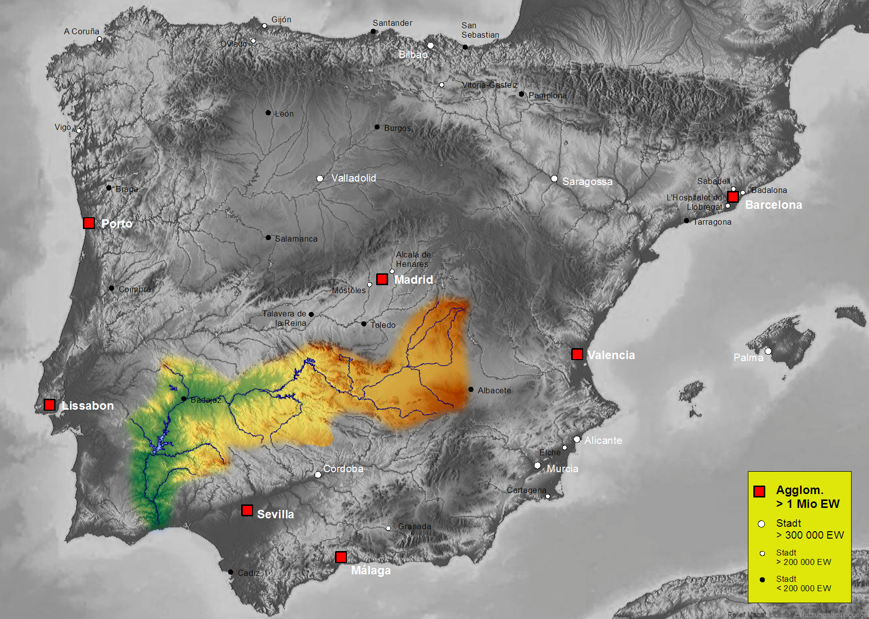
| Beskrivelse | Map of Guadiana river basin in Spain, Karte des hydrogeografischen Beckens des Guadiana |
| Dato | |
| Kilde | Own work, based on an image of http://www.maps-for-free.com/ (Creative Commons Attribution Share Alike 3.0) |
| Opphavsperson | Port(u*o)s |
| Tillatelse (Gjenbruk av denne filen) |
Creative Commons Attribution Share Alike 3.0 |
Lisensiering
Denne filen er lisensiert under lisensen Creative Commons Navngivelse-DelPåSammeVilkår 3.0 Unported
- Du står fritt:
- til å dele – til å kopiere, distribuere og overføre verket
- til å blande – til å endre verket
- Under de følgende betingelsene:
- navngivelse – Du må kreditere verket på passende vis, lenke til lisensen og indikere hvorvidt det har blitt gjort endringer. Du kan gjøre det på enhver rimelig måte, men ikke på en måte som antyder at lisensgiveren støtter deg eller din bruk av verket.
- del på samme vilkår – Dersom du remikser, omarbeider eller på annen måte bygger på dette verket, må du kun distribuere resultatet under den samme eller en samsvarende lisens som denne.
Filhistorikk
Klikk på et tidspunkt for å vise filen slik den var på det tidspunktet.
| Dato/klokkeslett | Miniatyrbilde | Dimensjoner | Bruker | Kommentar | |
|---|---|---|---|---|---|
| nåværende | 7. okt. 2021 kl. 18:44 | | 1 751 × 1 248 (2,27 MB) | Lojwe | Santiago mal posicionada |
| 5. feb. 2019 kl. 03:56 |  | 1 751 × 1 248 (2,44 MB) | TouchName | recorte de marco | |
| 30. okt. 2007 kl. 03:59 |  | 1 808 × 1 307 (2,48 MB) | Port(u*o)s | == Summary == {{Information |Description=Map of Guadiana river basin in Spain, Karte des hydrogeografischen Beckens des Guadiana |Source= Own work, based on an image of http://www.maps-for-free.com/ (Creative Commons Attribution Share Alike 3.0) |Date=Oct |
Filbruk
Den følgende siden bruker denne filen:
Global filbruk
Følgende andre wikier bruker denne filen:
- Bruk i af.wikipedia.org
- Bruk i ast.wikipedia.org
- Bruk i be.wikipedia.org
- Bruk i cs.wikipedia.org
- Bruk i cv.wikipedia.org
- Bruk i da.wikipedia.org
- Bruk i de.wikipedia.org
- Bruk i el.wikipedia.org
- Bruk i en.wikipedia.org
- Bruk i es.wikipedia.org
- Guadiana
- Río Zújar
- Río Guadámez
- Río Guadalupe
- Riánsares
- Anexo:Ríos de España
- Río Ardila
- Río Gévora
- Usuario discusión:NACLE
- Río Estena
- Río Guadajira
- Río Caya
- Río Albarregas (España)
- Río Chanza
- Río Bedija
- Cuenca hidrográfica del Guadiana
- Godolid
- Río Estenilla
- Usuario:Strakhov/FOT
- Arroyo Grande (Castilblanco)
- Bruk i fr.wikipedia.org
- Bruk i he.wikipedia.org
- Bruk i hu.wikipedia.org
- Bruk i is.wikipedia.org
- Bruk i ja.wikipedia.org
- Bruk i kk.wikipedia.org
Vis mer global bruk av denne filen.