Fil:Shimabara-Battle-Map-c17th-century.png

Opprinnelig fil(3 195 × 3 121 piksler, filstørrelse: 16,15 MB, MIME-type: image/png)


Wikimedia Commons' logo

Beskrivelse

Beskrivelse
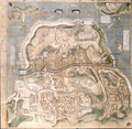
English: This is an Important Cultural Property. A map depicting the Amakusa / Shimabara Rebellion centered on Hara Castle. From the beginning of February in the 15th year of Kanei (1638), when the Kyushu daimyo entered the siege of Hara Castle, the process of the total attack and even the situation after the fall of the castle are depicted. Among the many maps of the Hara Castle attack, the details and accuracy of the description are first-class, and its reputation has been high since the Edo period. The maps shows the Tachibana clan is in the position of Sannomarushita along with the Hosokawa clan. This map is known to be the most accurate of the many drawings depicting the Shimabara Rebellion.
日本語: 【重要文化財】。「島原御陣図」(17世紀頃)。原城を中心に、天草・島原の乱を描いた絵図。ここには、九州諸大名が原城包囲に入った寛永一五年(一六三八)、二月上旬から、総攻撃の過程、さらには落城後の状況までも描き込まれている。数ある原城攻めの絵図の中でも、記載の詳細さと正確さは第一級であり、江戸時代からその評判が高かったことが窺われる。絵図中、立花勢は、細川勢とともに三ノ丸下に陣取っている様子がみられる。数ある島原の乱を描いた絵図のなかでも、もっとも正確なものとして知られる。
Dato Circa 17th century
Kilde Yanagawa Ancient Archives - https://www.city.yanagawa.fukuoka.jp/blog-buka/2020/_7900/_7933.html
Opphavsperson UkjentUnknown author

Lisensiering

This is a faithful photographic reproduction of a two-dimensional, public domain work of art. The work of art itself is in the public domain for the following reason:
Public domain

Dette verket er offentlig eiendom i Norge, EU og land der den opphavsrettslige vernetiden etter opphavsmannens død er 100 år eller kortere. Merk at noen land har lengre vernetid.


For å kunne lagres på Commons må verket både være offentlig eiendom i USA og i opphavslandet. Vernetiden kan i noen tilfeller være lengre enn 80 år i USA, så i tillegg til dette merket trengs det et eget merke som forklarer hvorfor verket er offentlig eiendom (public domain) i USA.
The official position taken by the Wikimedia Foundation is that "faithful reproductions of two-dimensional public domain works of art are public domain".
This photographic reproduction is therefore also considered to be in the public domain in the United States. In other jurisdictions, re-use of this content may be restricted; see Reuse of PD-Art photographs for details.

Bildetekster

Legg til en kort forklaring på hva filen representerer
Shimabara Battle Map, circa 17th century.

Elementer som er med i denne fila

motiv

image/png

Filhistorikk

Klikk på et tidspunkt for å vise filen slik den var på det tidspunktet.

Dato/klokkeslettMiniatyrbildeDimensjonerBrukerKommentar
nåværende3. des. 2021 kl. 15:22Miniatyrbilde av versjonen fra 3. des. 2021 kl. 15:223 195 × 3 121 (16,15 MB)ArtanisenUploaded a work by Unknown (created circa 17th century) from Yanagawa Ancient Archives - https://www.city.yanagawa.fukuoka.jp/blog-buka/2020/_7900/_7933.html with UploadWizard

Den følgende siden bruker denne filen:

Global filbruk

Følgende andre wikier bruker denne filen:

Metadata