Fil:ProtectorateOfSouthArabiaMap.jpg

Størrelse på denne forhåndsvisningen: 800 × 584 piksler. Andre oppløsninger: 320 × 234 piksler | 640 × 467 piksler | 912 × 666 piksler.
Opprinnelig fil (912 × 666 piksler, filstørrelse: 273 KB, MIME-type: image/jpeg)
| Denne filen er fra Wikimedia Commons og kan brukes av andre prosjekter. Informasjonen fra filbeskrivelsessiden vises nedenfor. |

|
Dette bildet bør gjenskapes med hjelp av vektorgrafikk som en SVG-fil. Dette har flere fordeler, se Commons:Media for cleanup for mer informasjon. Hvis en SVG-fil med dette bildet er tilgjengelig, vennligst last den opp. Etter opplasting erstatt denne malen med {{vector version available|nytt bilde.svg}}.
|


|
This map has been uploaded by Electionworld from en.wikipedia.org to enable the |
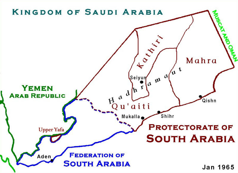
Beskrivelse
Based on Work of US Government agency. Another version in russian is available.
Lisensiering
This work is in the public domain in the United States because it is a work prepared by an officer or employee of the United States Government as part of that person’s official duties under the terms of Title 17, Chapter 1, Section 105 of the US Code.
Note: This only applies to original works of the Federal Government and not to the work of any individual U.S. state, territory, commonwealth, county, municipality, or any other subdivision. This template also does not apply to postage stamp designs published by the United States Postal Service since 1978. (See § 313.6(C)(1) of Compendium of U.S. Copyright Office Practices). It also does not apply to certain US coins; see The US Mint Terms of Use.
|
 | |
| Denne filen har blitt identifisert til å være fri for kjente restriksjoner under lov om opphavsrett, inkludert alle relaterte og nærstående rettigheter. | ||
Filhistorikk
Klikk på et tidspunkt for å vise filen slik den var på det tidspunktet.
| Dato/klokkeslett | Miniatyrbilde | Dimensjoner | Bruker | Kommentar | |
|---|---|---|---|---|---|
| nåværende | 18. jan. 2010 kl. 04:12 | | 912 × 666 (273 KB) | Anonimosanhueza | borders removed |
| 28. nov. 2008 kl. 03:14 |  | 928 × 682 (284 KB) | Nickpo | {{svg|map}} {{ew|en|AjaxSmack}} == Summary == Based on Work of US Government agency == Licensing == {{PD-USGov}} Category:Maps of Yemen Category:Qu'aiti State of Shihr and Mukalla Category:Federation of South Arabia [[Category:Kathiri State | |
| 18. des. 2006 kl. 00:56 |  | 928 × 682 (118 KB) | Electionworld | {{ew|en|AjaxSmack}} == Summary == Based on Work of US Government agency == Licensing == {{PD-USGov}} |
Filbruk
Den følgende siden bruker denne filen:
Global filbruk
Følgende andre wikier bruker denne filen:
- Bruk i ar.wikipedia.org
- Bruk i be.wikipedia.org
- Bruk i bn.wikipedia.org
- Bruk i ca.wikipedia.org
- Bruk i cs.wikipedia.org
- Bruk i de.wikipedia.org
- Bruk i en.wikipedia.org
- Bruk i es.wikipedia.org
- Bruk i fr.wikipedia.org
- Bruk i fr.wiktionary.org
- Bruk i hr.wikipedia.org
- Bruk i id.wikipedia.org
- Bruk i it.wikipedia.org
- Bruk i ja.wikipedia.org
- Bruk i lt.wikipedia.org
- Bruk i mk.wikipedia.org
- Bruk i pl.wikipedia.org
- Bruk i pnb.wikipedia.org
- Bruk i pt.wikipedia.org
- Bruk i ru.wikipedia.org
Vis mer global bruk av denne filen.