Fil:Portuguese colonial war map1.PNG
Ingen høyere oppløsning tilgjengelig.
Portuguese_colonial_war_map1.PNG (360 × 392 piksler, filstørrelse: 12 KB, MIME-type: image/png)
| Denne filen er fra Wikimedia Commons og kan brukes av andre prosjekter. Informasjonen fra filbeskrivelsessiden vises nedenfor. |

|
En vektorversjon av dette bildet (SVG) er tilgjengelig.
Det bør brukes i stedet for punktgrafikkbildet når det er fordelaktig. File:Portuguese colonial war map1.PNG → File:Portuguese colonial war blank map.svg
For mer informasjon om vektorgrafikk les Commons transition to SVG. Se også information about MediaWiki's support of SVG images. |
 |
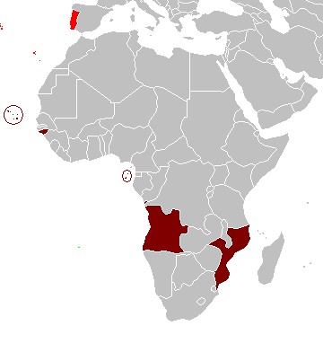
Beskrivelse
Map of the Portuguese colonies in Africa by the time of the Portuguese Colonial War (1961-1974).
Source
- English Wikipedia, uploaded by User:Mário
Revision history
12:19, 8 April 2006 . . Mário (Talk | contribs) . . 360×392 (12,409 bytes) (Map of the Portuguese colonies in Africa by the time of the Portuguese Colonial War (1961-1974).)
Lisensiering
| Jeg, opphavsrettensholderen til dette verket, frigir dette verket til allmennheten. Dette gjelder på verdensbasis. I enkelte land kan dette være juridisk umulig. I så fall: Jeg gir hvem som helst retten til å bruke dette verket for ethvert formål, uten noen vilkår, med mindre slike vilkår kreves ved lov. |
Filhistorikk
Klikk på et tidspunkt for å vise filen slik den var på det tidspunktet.
| Dato/klokkeslett | Miniatyrbilde | Dimensjoner | Bruker | Kommentar | |
|---|---|---|---|---|---|
| nåværende | 5. mar. 2008 kl. 12:17 | | 360 × 392 (12 KB) | The Ogre | Enhanced visualization |
| 26. nov. 2007 kl. 21:51 |  | 360 × 392 (12 KB) | Hoshie | added Cabinda, updated base map | |
| 12. aug. 2006 kl. 16:46 |  | 360 × 392 (12 KB) | Nuno Tavares | == Summary == Map of the Portuguese colonies in Africa by the time of the Portuguese Colonial War (1961-1974). ==Source== <pre> 12:19, 8 April 2006 . . Mário (Talk | contribs) . . 360×392 (12,409 bytes) (Map of the Portuguese colonies i |
Filbruk
Det er ingen sider som bruker denne filen.
Global filbruk
Følgende andre wikier bruker denne filen:
- Bruk i de.wikipedia.org
- Bruk i en.wikipedia.org
- Bruk i fr.wikipedia.org
- Bruk i ja.wikipedia.org