Fil:Old map of Vietnam.jpg

Opprinnelig fil (3 024 × 2 179 piksler, filstørrelse: 1,99 MB, MIME-type: image/jpeg)
| Denne filen er fra Wikimedia Commons og kan brukes av andre prosjekter. Informasjonen fra filbeskrivelsessiden vises nedenfor. |
Beskrivelse
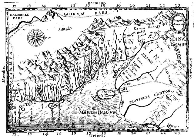
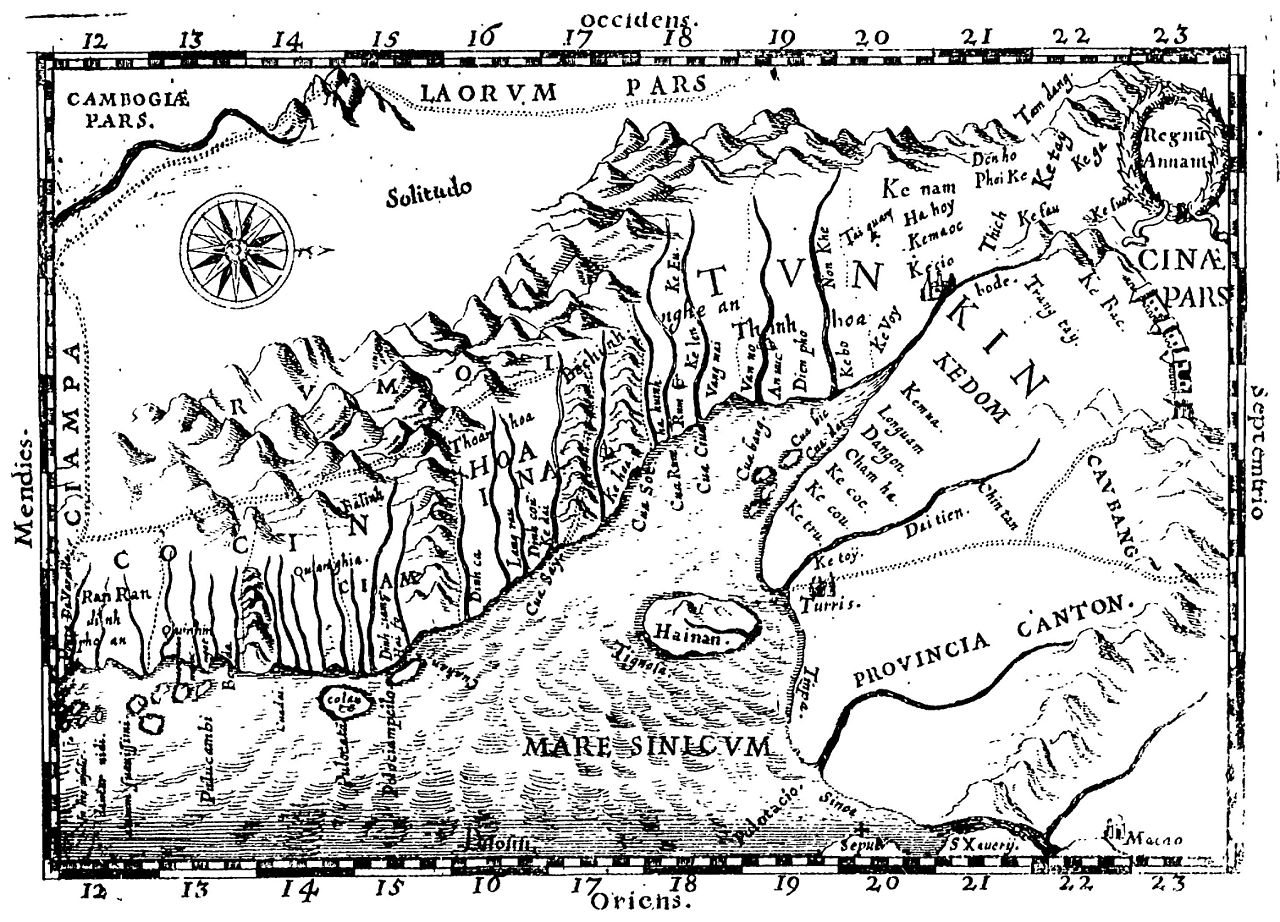
Early Western Map of Tonkin (1651). One of the earliest Western maps showing details of northern and central Vietnam appeared in Father Alexander de Rhodes's Histoire dv royavme de Tvnqvin, published in Rome in 1650. This map is from the French edition, published a year later in Lyon. Oriented with the north to the right, "Regnu Annam" shows the extent of seventeenth-century Vietnam, then divided between two rival dynasties, one in the north and the other in central Vietnam. Remnants of the Cham kingdom, eventually destroyed by the Vietnamese, still exist in the south. To the west, are the highlands occupied by "Rumoi" (upland minority groups, later called "montagnards" by the French). The limited Western knowledge of the interior is illustrated by the large region labeled "Solitudo."
(originally from https://www.loc.gov/rr/asian/guide/guide-southern.html) High-resolution version from The BNF
Lisensiering
|
Dette verket er offentlig eiendom i Norge, EU og land der den opphavsrettslige vernetiden etter opphavsmannens død er 70 år eller kortere. Merk at noen land har lengre vernetid.
| |
| Denne filen har blitt identifisert til å være fri for kjente restriksjoner under lov om opphavsrett, inkludert alle relaterte og nærstående rettigheter. | |
Filhistorikk
Klikk på et tidspunkt for å vise filen slik den var på det tidspunktet.
| Dato/klokkeslett | Miniatyrbilde | Dimensjoner | Bruker | Kommentar | |
|---|---|---|---|---|---|
| nåværende | 20. apr. 2011 kl. 22:28 | | 3 024 × 2 179 (1,99 MB) | Dragfyre | cropped to center the map image |
| 22. mai 2009 kl. 13:52 |  | 3 298 × 2 581 (1,4 MB) | DHN | updating high-res version | |
| 9. sep. 2006 kl. 14:39 |  | 640 × 473 (105 KB) | DHN | Early Western Map of Tonkin (1651). One of the earliest Western maps showing details of northern and central Vietnam appeared in Father Alexander de Rhodes's Histoire dv royavme de Tvnqvin, published in Rome in 1650. This map is from the French edition, |
Filbruk
De følgende 2 sidene bruker denne filen:
Global filbruk
Følgende andre wikier bruker denne filen:
- Bruk i ast.wikipedia.org
- Bruk i azb.wikipedia.org
- Bruk i az.wikipedia.org
- Bruk i bn.wikipedia.org
- Bruk i br.wikipedia.org
- Bruk i ca.wikipedia.org
- Bruk i ceb.wikipedia.org
- Bruk i da.wikipedia.org
- Bruk i de.wikipedia.org
- Bruk i en.wikipedia.org
- Bruk i en.wiktionary.org
- Bruk i eo.wikipedia.org
- Bruk i es.wikipedia.org
- Bruk i fr.wikipedia.org
- Bruk i gl.wikipedia.org
- Bruk i id.wikipedia.org
- Bruk i it.wikipedia.org
- Bruk i ja.wikipedia.org
- Bruk i km.wikipedia.org
- Bruk i ms.wikipedia.org
- Bruk i pl.wikipedia.org
- Bruk i pt.wikipedia.org
- Bruk i sl.wikipedia.org
- Bruk i sv.wikipedia.org
- Bruk i vi.wikipedia.org