Fil:NovoLisice.jpg

Størrelse på denne forhåndsvisningen: 587 × 600 piksler. Andre oppløsninger: 235 × 240 piksler | 470 × 480 piksler | 752 × 768 piksler | 1 002 × 1 024 piksler | 2 005 × 2 048 piksler | 3 000 × 3 065 piksler.
Opprinnelig fil (3 000 × 3 065 piksler, filstørrelse: 3,5 MB, MIME-type: image/jpeg)
| Denne filen er fra Wikimedia Commons og kan brukes av andre prosjekter. Informasjonen fra filbeskrivelsessiden vises nedenfor. |
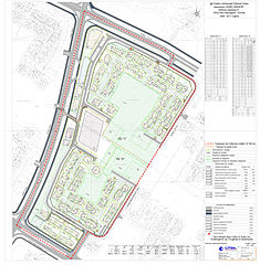
| Beskrivelse | The graphical scheme of the Detailed urban plan for a settlement (urban area A) within the Aerodrom municipality of the city of Skopje, Republic of Macedonia. The graphical scheme contains different zones which are designated with different colors in the graph on the right side of the photo. | |||
| Dato | ||||
| Kilde | [1] | |||
| Opphavsperson | Council of the Municipality of Aerodrom | |||
| Tillatelse (Gjenbruk av denne filen) |
|

![[1]](http://www.aerodrom.gov.mk/Images/dup/NovoLisice.jpg)
Filhistorikk
Klikk på et tidspunkt for å vise filen slik den var på det tidspunktet.
| Dato/klokkeslett | Miniatyrbilde | Dimensjoner | Bruker | Kommentar | |
|---|---|---|---|---|---|
| nåværende | 3. apr. 2010 kl. 10:54 | | 3 000 × 3 065 (3,5 MB) | Модернист | {{Information |Description=The graphical scheme of the Detailed urban plan for a settlement (urban area A) within the Aerodrom municipality of the city of Skopje, Republic of Macedonia. The graphical scheme contains different zones which are desig |
Filbruk
Den følgende siden bruker denne filen:
Global filbruk
Følgende andre wikier bruker denne filen:
- Bruk i an.wikipedia.org
- Bruk i bn.wikipedia.org
- Bruk i en.wikipedia.org
- Bruk i es.wikipedia.org
- Bruk i fr.wikipedia.org
- Bruk i ha.wikipedia.org
- Bruk i hu.wikipedia.org
- Bruk i ja.wikipedia.org
- Bruk i mk.wikipedia.org
- Bruk i ml.wikipedia.org
- Bruk i sr.wikipedia.org
- Bruk i vi.wikipedia.org
- Bruk i www.wikidata.org
- Bruk i zh.wikipedia.org