Fil:North West England counties 2009 map.svg

Størrelse for denne PNG-forhåndsvisningen av denne SVG-filen: 300 × 599 piksler Andre oppløsninger: 120 × 240 piksler | 240 × 480 piksler | 385 × 768 piksler | 513 × 1 024 piksler | 1 026 × 2 048 piksler | 674 × 1 345 piksler.
Opprinnelig fil (SVG-fil, standardstørrelse 674 × 1 345 piksler, filstørrelse: 1,39 MB)
| Denne filen er fra Wikimedia Commons og kan brukes av andre prosjekter. Informasjonen fra filbeskrivelsessiden vises nedenfor. |
Beskrivelse
| Beskrivelse |
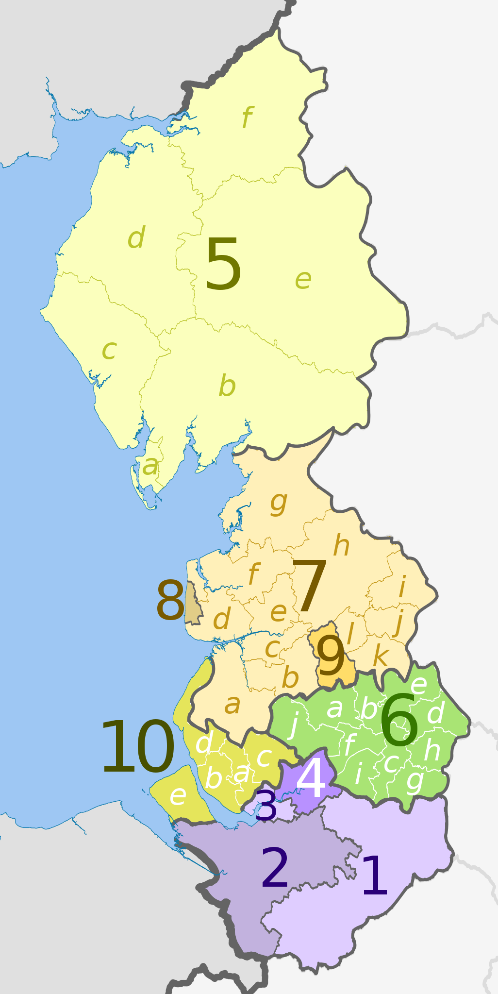
English: Map of the North West England region, showing its counties and administrative districts until 31 March 2023. The county colours are the same as those in File:English metropolitan and non-metropolitan counties 2009.svg.
For counties since 1 April 2023, see File:North West England counties 2023 map.svg. Equirectangular map projection on WGS 84 datum, with N/S stretched 170% Geographic limits:
|
| Dato | (UTC) |
| Kilde |
This file was derived from: |
| Opphavsperson |
|
| Andre versjoner | File:North West England counties 2023 map.svg – version since 1 April 2023 |


| Map | Ceremonial county | County/Unitary | Metropolitan/non-metropolitan districts |
|---|---|---|---|
 |
Cheshire | 1. Cheshire East U.A. | |
| 2. Cheshire West and Chester U.A. | |||
| 3. Halton U.A. | |||
| 4. Warrington U.A. | |||
| 5. Cumbria † | a) Barrow-in-Furness, b) South Lakeland, c) Copeland, d) Allerdale, e) Eden, f) Carlisle | ||
| 6. Greater Manchester * | a) Bolton, b) Bury, c) Manchester, d) Oldham, e) Rochdale, f) Salford, g) Stockport, h) Tameside, i) Trafford, j) Wigan | ||
| Lancashire | 7. Lancashire † | a) West Lancashire, b) Chorley, c) South Ribble, d) Fylde, e) Preston, f) Wyre, g) Lancaster, h) Ribble Valley, i) Pendle, j) Burnley, k) Rossendale, l) Hyndburn | |
| 8. Blackpool U.A. | |||
| 9. Blackburn with Darwen U.A. | |||
| 10. Merseyside * | a) Knowsley, b) Liverpool, c) St. Helens, d) Sefton, e) Wirral | ||
Key: †shire county | *metropolitan county
Lisensiering
Denne filen er lisensiert under lisensen Creative Commons Navngivelse-DelPåSammeVilkår 3.0 Unported
Navngivelse: Dr Greg and Nilfanion. Contains Ordnance Survey data © Crown copyright and database right 2011
- Du står fritt:
- til å dele – til å kopiere, distribuere og overføre verket
- til å blande – til å endre verket
- Under de følgende betingelsene:
- navngivelse – Du må kreditere verket på passende vis, lenke til lisensen og indikere hvorvidt det har blitt gjort endringer. Du kan gjøre det på enhver rimelig måte, men ikke på en måte som antyder at lisensgiveren støtter deg eller din bruk av verket.
- del på samme vilkår – Dersom du remikser, omarbeider eller på annen måte bygger på dette verket, må du kun distribuere resultatet under den samme eller en samsvarende lisens som denne.
Orginal opplastningslogg
This image is a derivative work of the following images:
- File:North_West_England_districts_2011_map.svg licensed with Cc-by-sa-3.0, GFDL
- 2011-05-01T19:03:10Z Nilfanion 674x1345 (1403071 Bytes) == Summary == {{Information |Description=Map of the [[w:North West England|North West England]] region showing the administrative districts. Equirectangular map projection on WGS 84 datum, with N/S stretched 170% Geographic
- File:English_ceremonial_counties_2010.svg licensed with Cc-by-sa-3.0, GFDL
- 2010-11-23T16:39:55Z Nilfanion 1108x1345 (308868 Bytes) thicker lines
- 2010-11-23T16:20:19Z Nilfanion 1108x1345 (301520 Bytes) tweaks
- 2010-10-26T20:34:20Z Nilfanion 817x990 (1391832 Bytes) {{Information |Description=Map showing the [[w:ceremonial counties of England]] including the City of London, in 2010. Equirectangular map projection on WGS 84 datum, with N/S stretched 170% Geographic limits: *West: 6.75W
Uploaded with derivativeFX
Filhistorikk
Klikk på et tidspunkt for å vise filen slik den var på det tidspunktet.
| Dato/klokkeslett | Miniatyrbilde | Dimensjoner | Bruker | Kommentar | |
|---|---|---|---|---|---|
| nåværende | 5. mai 2012 kl. 22:08 | | 674 × 1 345 (1,39 MB) | Dr Greg | lighten black boundary line |
| 2. mai 2012 kl. 01:16 |  | 674 × 1 345 (1,39 MB) | Dr Greg | == {{int:filedesc}} == {{Information |Description={{en|Map of the North West England region, showing its counties and administrative districts. The county colours are the same as those in [[:File:English metropolitan and non-me... |
Filbruk
Den følgende siden bruker denne filen:
Global filbruk
Følgende andre wikier bruker denne filen:
- Bruk i ar.wikipedia.org
- Bruk i fa.wikipedia.org
- Bruk i frr.wikipedia.org
- Bruk i hr.wikipedia.org
- Bruk i hu.wikipedia.org
- Bruk i mr.wikipedia.org
- Bruk i pl.wikipedia.org
- Bruk i pnb.wikipedia.org
- Bruk i pt.wikipedia.org
- Bruk i ru.wikipedia.org
- Bruk i sh.wikipedia.org
- Bruk i th.wikipedia.org
- Bruk i ur.wikipedia.org
- Bruk i vi.wikipedia.org
- Bruk i vls.wikipedia.org
- Bruk i zh-yue.wikipedia.org