Fil:New Zealand map.PNG
New_Zealand_map.PNG (323 × 590 piksler, filstørrelse: 89 KB, MIME-type: image/png)
| Denne filen er fra Wikimedia Commons og kan brukes av andre prosjekter. Informasjonen fra filbeskrivelsessiden vises nedenfor. |
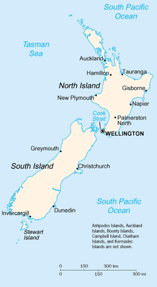
A map of New Zealand showing the major cities and towns. Not shown are the Antipodes Islands, Auckland Islands, Bounty Islands, Campbell Island, The Snares, and the Kermadec Islands.
https://www.cia.gov/library/publications/the-world-factbook/geos/nz.html archive copy at the Wayback Machine
It should be noted that the scale on this map is not accurate. Measuring distances on the map then using the scale to determine those distances on the ground would lead to considerable exaggeration of those distances. This issue has been raised with the CIA, who compile these World Fact Book maps.
- Update - the latest version updated by Grutness is much better. Please see the Talk page for more.
Dette biletet er offentleg eigedom av di det inneheld tilfang som kjem frå Sambandsstatanes Central Intelligence Agency si Allkunnebok over verda.
|
 |
Filhistorikk
Klikk på et tidspunkt for å vise filen slik den var på det tidspunktet.
| Dato/klokkeslett | Miniatyrbilde | Dimensjoner | Bruker | Kommentar | |
|---|---|---|---|---|---|
| nåværende | 30. jul. 2005 kl. 03:14 | | 323 × 590 (89 KB) | Grutness | scale corrected |
| 30. jul. 2005 kl. 03:04 |  | 323 × 590 (100 KB) | Grutness | Scale corrected | |
| 6. mai 2005 kl. 06:24 |  | 323 × 590 (21 KB) | Evil Monkey | World Factbook map cropped and modified but still PD |
Filbruk
Den følgende siden bruker denne filen:
Global filbruk
Følgende andre wikier bruker denne filen:
- Bruk i an.wikipedia.org
- Bruk i bbc.wikipedia.org
- Bruk i be-tarask.wikipedia.org
- Bruk i br.wikipedia.org
- Bruk i bs.wikipedia.org
- Bruk i cs.wikipedia.org
- Bruk i de.wikipedia.org
- Bruk i de.wikinews.org
- Bruk i en.wikipedia.org
- Bruk i en.wiktionary.org
- Bruk i es.wikinews.org
- Bruk i eu.wikipedia.org
- Bruk i fr.wikipedia.org
- Bruk i fr.wiktionary.org
- Bruk i gd.wikipedia.org
- Bruk i gl.wikipedia.org
- Bruk i he.wikipedia.org
- Bruk i hi.wikipedia.org
- Bruk i hr.wikipedia.org
- Bruk i io.wikipedia.org
- Bruk i it.wikipedia.org
- Bruk i ka.wikipedia.org
- Bruk i la.wikipedia.org
- Bruk i lt.wikipedia.org
- Bruk i ml.wikipedia.org
- Bruk i mr.wikipedia.org
- Bruk i nds-nl.wikipedia.org
- Bruk i nl.wikipedia.org
- Bruk i nn.wikipedia.org
- Bruk i pl.wikipedia.org
- Bruk i pl.wikibooks.org
- Bruk i pl.wikivoyage.org
- Bruk i pt.wikipedia.org
- Bruk i ru.wikipedia.org
- Bruk i ru.wikinews.org
- Bruk i sr.wikipedia.org
- Bruk i sv.wikipedia.org
Vis mer global bruk av denne filen.