Fil:NepalBaglungDistrictmap.png

Opprinnelig fil (3 508 × 2 479 piksler, filstørrelse: 379 KB, MIME-type: image/png)
| Denne filen er fra Wikimedia Commons og kan brukes av andre prosjekter. Informasjonen fra filbeskrivelsessiden vises nedenfor. |
| Beskrivelse |
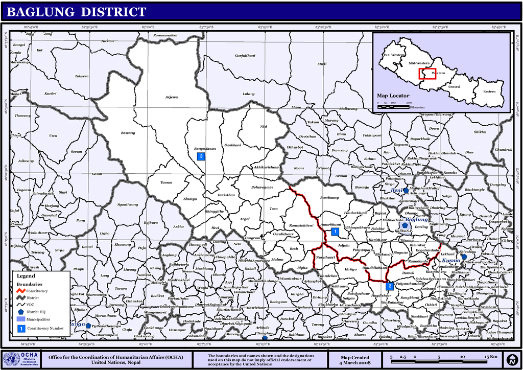
English: Map displaying Village Development Committees in Baglung District, Nepal |
|||
| Dato | ||||
| Kilde | http://www.un.org.np/maps/district-maps/western/Baglung.pdf | |||
| Opphavsperson | United Nations | |||
| Tillatelse (Gjenbruk av denne filen) |
|

Filhistorikk
Klikk på et tidspunkt for å vise filen slik den var på det tidspunktet.
| Dato/klokkeslett | Miniatyrbilde | Dimensjoner | Bruker | Kommentar | |
|---|---|---|---|---|---|
| nåværende | 6. nov. 2008 kl. 03:34 | | 3 508 × 2 479 (379 KB) | Sadalmelik | {{Information |Description={{en|1=Map displaying Village Development Committees in Baglung District, Nepal}} |Source=http://www.un.org.np/maps/district-maps/western/Baglung.pdf |Date=March 4, 2008 |Author=United Nations |Permission={{PD-UN}} |other_ve |
Filbruk
Den følgende siden bruker denne filen:
Global filbruk
Følgende andre wikier bruker denne filen:
- Bruk i bpy.wikipedia.org
- Bruk i de.wikipedia.org
- Bruk i en.wikipedia.org
- Bruk i fi.wikipedia.org
- Bruk i mai.wikipedia.org
- आकृति:बागलुङ जिलाक गाविस तथा नगरपालिकासभ
- अधिकारीचौर
- अर्गल
- अर्जेवा
- अमरभुमी
- अमलाचौर
- काँडेवास
- कुस्मीशेरा
- खुङखानी
- खुंगा
- ग्वालीचौर
- छिस्ती
- जलजला, बागलुङ
- जैदी
- तमान
- तारा गाविस
- तित्याङ
- दगातुन्डाँडा
- दमेक
- दर्लिङ
- दुदिलाभाटी
- देविस्थान, बागलुङ
- धम्जा
- धुल्लुवास्कोट
- नरेठाँटी
- नारायणस्थान, बागलुङ
- निसी
- पाला
- पाण्डवखानी
- पैयुँपाटा
- पैयुँथन्थाप
- बाटाकाचौर
- बिहुँकोट
- बिनामारे
- बुर्तिबाङ
- बुंगादोभान
- बोहरागाउँ
- बोवाङ
- हुग्दीशिर
- हिल
- हरीचौर
- हटिया, बागलुङ
- भकुण्डे
- भिमपोखरा
- भिमगिठे
Vis mer global bruk av denne filen.