Fil:NEAT GBT engl.png

Størrelse på denne forhåndsvisningen: 539 × 600 piksler. Andre oppløsninger: 216 × 240 piksler | 431 × 480 piksler | 852 × 948 piksler.
Opprinnelig fil (852 × 948 piksler, filstørrelse: 1,91 MB, MIME-type: image/png)
| Denne filen er fra Wikimedia Commons og kan brukes av andre prosjekter. Informasjonen fra filbeskrivelsessiden vises nedenfor. |
Beskrivelse
| Beskrivelse |
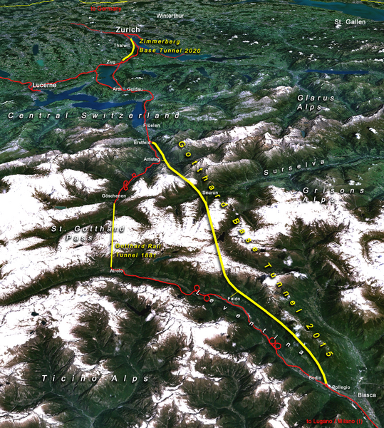
Situation of the northern part of the Gotthard axis as part of the New Railway Link through the Alps NRLA / Alptransit project in Switzerland with Gotthard and Zimmerberg base tunnels |
| Dato | |
| Kilde | topomap: produced with NASA WorldWind 1.3 / overlay drawing by: Cooper.ch |
| Opphavsperson | --Cooper.ch 19:30, 12 August 2006 (UTC) |
| Tillatelse (Gjenbruk av denne filen) |
NASA satellite imagery is in public domain, and so is my overlay drawing |
| Andre versjoner | Original german version on de.wikipedia.org, named Bild:NEAT_Gotthardachse.png |
Lisensiering
| This file is in the public domain in the United States because it was solely created by NASA. NASA copyright policy states that "NASA material is not protected by copyright unless noted". (See Template:PD-USGov, NASA copyright policy page or JPL Image Use Policy.) | ||
 |
Warnings:
|
| Annotations | This image is annotated: View the annotations at Commons |


Filhistorikk
Klikk på et tidspunkt for å vise filen slik den var på det tidspunktet.
| Dato/klokkeslett | Miniatyrbilde | Dimensjoner | Bruker | Kommentar | |
|---|---|---|---|---|---|
| nåværende | 12. aug. 2006 kl. 21:30 | | 852 × 948 (1,91 MB) | Cooper.ch | {{Information |Description=Situation of the northern axis of the New Railway Link through the Alps NRLA in Switzerland with Gotthard and Zimmerberg base tunnels |Source=topomap: produced with NASA WorldWind 1.3 / drawing overlay by: [[User:Cooper.ch|Coope |
Filbruk
Den følgende siden bruker denne filen:
Global filbruk
Følgende andre wikier bruker denne filen:
- Bruk i ast.wikipedia.org
- Bruk i bh.wikipedia.org
- Bruk i da.wikipedia.org
- Bruk i en.wikipedia.org
- Bruk i es.wikipedia.org
- Bruk i fa.wikipedia.org
- Bruk i fi.wikipedia.org
- Bruk i fr.wikipedia.org
- Bruk i he.wikipedia.org
- Bruk i hr.wikipedia.org
- Bruk i ja.wikipedia.org
- Bruk i jv.wikipedia.org
- Bruk i ml.wikipedia.org
- Bruk i my.wikipedia.org
- Bruk i nl.wikipedia.org
- Bruk i pt.wikipedia.org
- Bruk i rm.wikipedia.org
- Bruk i ro.wikipedia.org
- Bruk i sh.wikipedia.org
- Bruk i sl.wikipedia.org
- Bruk i sv.wikipedia.org
- Bruk i ta.wikinews.org
- Bruk i tr.wikipedia.org
- Bruk i zh.wikipedia.org