Fil:Map of Christmas Island 1976.jpg

Størrelse på denne forhåndsvisningen: 657 × 600 piksler. Andre oppløsninger: 263 × 240 piksler | 526 × 480 piksler | 839 × 766 piksler.
Opprinnelig fil (839 × 766 piksler, filstørrelse: 692 KB, MIME-type: image/jpeg)
| Denne filen er fra Wikimedia Commons og kan brukes av andre prosjekter. Informasjonen fra filbeskrivelsessiden vises nedenfor. |
Beskrivelse
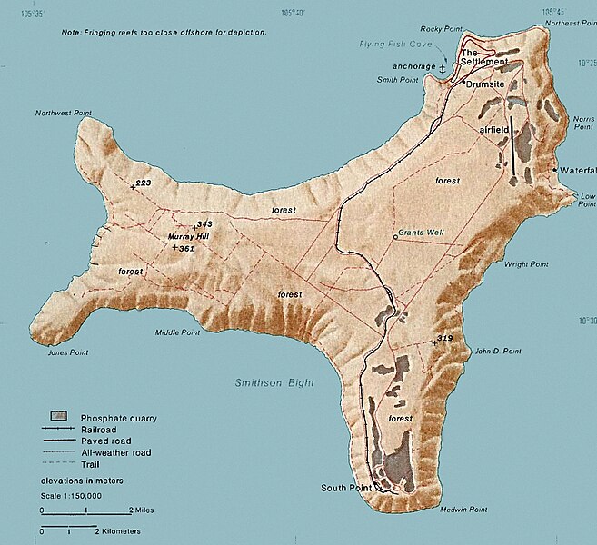
| Beskrivelse | Map of Christmas. This map was produced by the U.S. Central Intelligence Agency, unless otherwise indicated. Maps dated 1976 were taken from The Indian Ocean Atlas, published by the Central Intelligence Agency. |
| Dato | dated 1976 |
| Kilde | http://www.lib.utexas.edu/maps/islands_oceans_poles/christmas_island_76.jpg |
| Opphavsperson | Ukjent |
Lisensiering
| This image is a work of a Central Intelligence Agency employee, taken or made as part of that person's official duties. As a Work of the United States Government, this image or media is in the public domain in the United States.
|

|
Filhistorikk
Klikk på et tidspunkt for å vise filen slik den var på det tidspunktet.
| Dato/klokkeslett | Miniatyrbilde | Dimensjoner | Bruker | Kommentar | |
|---|---|---|---|---|---|
| nåværende | 3. feb. 2018 kl. 17:24 | | 839 × 766 (692 KB) | Hohum | Cleanup |
| 18. des. 2010 kl. 22:33 |  | 839 × 766 (365 KB) | Ras67 | cropped | |
| 11. feb. 2006 kl. 21:15 |  | 839 × 774 (128 KB) | Walden69 | Map of Christmas. This map were produced by the U.S. Central Intelligence Agency, unless otherwise indicated. Maps dated 1976 were taken from The Indian Ocean Atlas, published by the Central Intelligence Agency. {{PD-USGov-CIA}} |
Filbruk
De følgende 4 sidene bruker denne filen:
Global filbruk
Følgende andre wikier bruker denne filen:
- Bruk i ar.wikipedia.org
- Bruk i arz.wikipedia.org
- Bruk i ast.wikipedia.org
- Bruk i bs.wikipedia.org
- Bruk i ca.wikipedia.org
- Bruk i ceb.wikipedia.org
- Bruk i de.wikipedia.org
- Bruk i el.wikipedia.org
- Bruk i en.wikipedia.org
- Christmas Island
- Christmas Island Airport
- Christmas imperial pigeon
- Postage stamps and postal history of Christmas Island
- List of butterflies of Australia
- Murray Hill, Christmas Island
- List of moths of Christmas Island
- Christmas Island Phosphate Co.'s Railway
- Christmas Island flying fox
- Wildlife of Christmas Island
- Bruk i en.wikiversity.org
- Bruk i en.wikivoyage.org
- Bruk i eo.wikipedia.org
- Bruk i es.wikipedia.org
- Bruk i et.wikipedia.org
- Bruk i eu.wikipedia.org
- Bruk i fa.wikipedia.org
- Bruk i fr.wikipedia.org
- Bruk i gl.wikipedia.org
- Bruk i gu.wikipedia.org
- Bruk i hi.wikipedia.org
- Bruk i hi.wiktionary.org
- Bruk i hu.wikipedia.org
- Bruk i it.wikipedia.org
- Bruk i ja.wikipedia.org
- Bruk i kk.wikipedia.org
- Bruk i la.wikipedia.org
- Bruk i lld.wikipedia.org
- Bruk i ml.wikipedia.org
- Bruk i ms.wikipedia.org
Vis mer global bruk av denne filen.