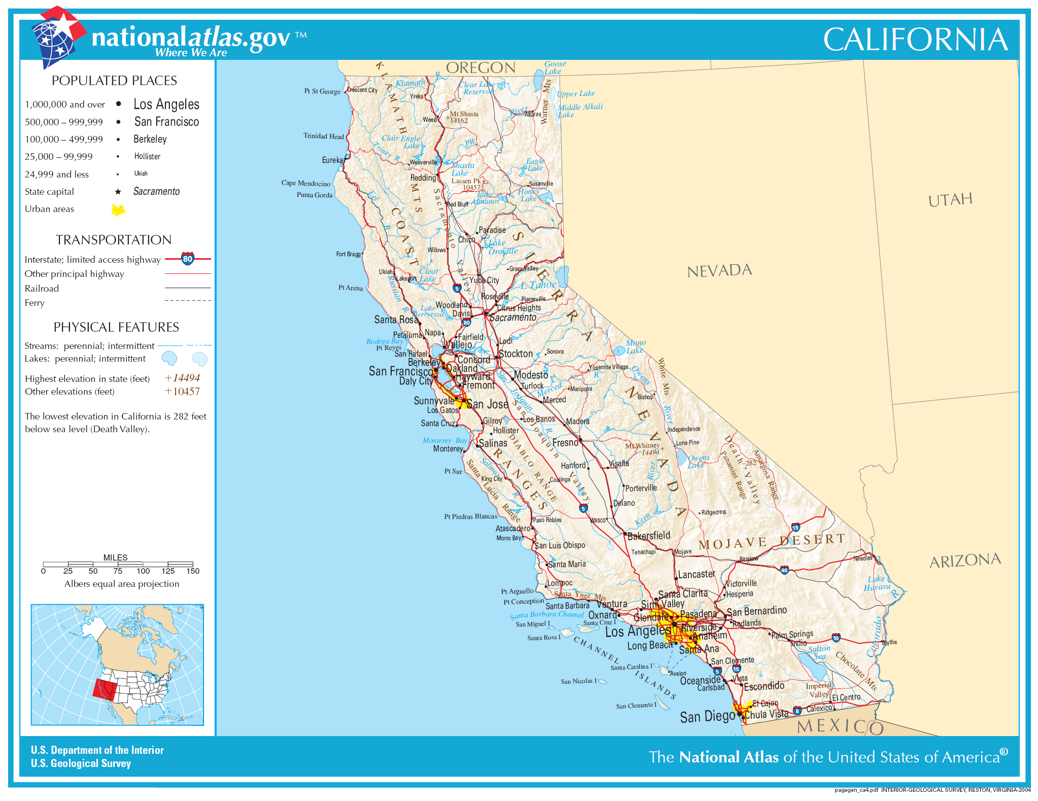
Fil:Map of California NA.png
Størrelse på denne forhåndsvisningen: 777 × 600 piksler. Andre oppløsninger: 311 × 240 piksler | 622 × 480 piksler | 995 × 768 piksler | 1 280 × 988 piksler | 2 046 × 1 579 piksler.
Opprinnelig fil (2 046 × 1 579 piksler, filstørrelse: 1,48 MB, MIME-type: image/png)
| Denne filen er fra Wikimedia Commons og kan brukes av andre prosjekter. Informasjonen fra filbeskrivelsessiden vises nedenfor. |
Beskrivelse
| Beskrivelse | |
| Dato | |
| Kilde | |
| Opphavsperson | National Atlas of the United States |
| Tillatelse (Gjenbruk av denne filen) |
Public domain |
Lisensiering
This map was obtained from an edition of the National Atlas of the United States. Like almost all works of the U.S. federal government, works from the National Atlas are in the public domain in the United States.
Online access: NationalAtlas.gov | 1970 print edition: Library of Congress, Perry-Castañeda Library
|
Filhistorikk
Klikk på et tidspunkt for å vise filen slik den var på det tidspunktet.
| Dato/klokkeslett | Miniatyrbilde | Dimensjoner | Bruker | Kommentar | |
|---|---|---|---|---|---|
| nåværende | 30. nov. 2006 kl. 08:34 | | 2 046 × 1 579 (1,48 MB) | Jengod | Crop to reduce excess whitespace on border |
| 14. aug. 2006 kl. 22:19 |  | 2 122 × 1 640 (1,55 MB) | Huebi~commonswiki | {{Information| |Description=Map of Valifornia |Source=[http://www.nationalatlas.gov National Atlas] }} Category:Maps of the United States Category:Maps of California {{PD-USGov-Atlas}} |
Filbruk
Den følgende siden bruker denne filen:
Global filbruk
Følgende andre wikier bruker denne filen:
- Bruk i als.wikipedia.org
- Bruk i be-tarask.wikipedia.org
- Bruk i bh.wikipedia.org
- Bruk i ca.wikipedia.org
- Bruk i de.wikipedia.org
- Bruk i en.wikipedia.org
- Bruk i eo.wikipedia.org
- Bruk i fa.wikipedia.org
- Bruk i fo.wikipedia.org
- Bruk i hi.wikipedia.org
- Bruk i hsb.wikipedia.org
- Bruk i hu.wikipedia.org
- Bruk i id.wikipedia.org
- Bruk i ilo.wikipedia.org
- Bruk i incubator.wikimedia.org
- Bruk i it.wikipedia.org
- Bruk i ja.wikipedia.org
Vis mer global bruk av denne filen.