Fil:Luke Foxe voyage account (North-West Fox, 1635) - 2 foldout map -1 full view.png

Opprinnelig fil (5 742 × 4 226 piksler, filstørrelse: 39,96 MB, MIME-type: image/png)
| Denne filen er fra Wikimedia Commons og kan brukes av andre prosjekter. Informasjonen fra filbeskrivelsessiden vises nedenfor. |
Beskrivelse
| Beskrivelse |
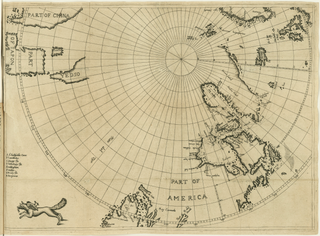
English: Fold-out engraved map from Luke Foxe's voyage account book, showing the route of his 1631 sea expedition from England (top right) in search of a Northwest passage towards Asia (top left) through Hudson Strait, exploring Hudson Bay and Foxe Basin (detail). The map uses the azimuthal equidistant projection, with the North Pole as its center point. At bottom left, near the Island of California, the map is decorated with a fox, the author's emblem.
|
||||||||||||||||||||
| Dato | |||||||||||||||||||||
| Kilde |
Courtesy of John Carter Brown Library at Brown University
|
||||||||||||||||||||
| Skaper |
|
||||||||||||||||||||
| Tillatelse (Gjenbruk av denne filen) |
|
||||||||||||||||||||
| Geotemporale data | |||||||||||||||||||||
| Forestilt dato | |||||||||||||||||||||
| Kartplassering | Hudson Bay, Hudson Strait, Baffin Bay, Arctic Canada, Greenland | ||||||||||||||||||||
| Karttype | nautical chart | ||||||||||||||||||||
| Kartprojeksjon | azimuthal equidistant centered on North Pole | ||||||||||||||||||||
| Avgrensningsboks |
|
||||||||||||||||||||
| Bibliografiske data | |||||||||||||||||||||
| Publikasjon | |||||||||||||||||||||
| Side(r) | fold-out map following p. 172 | ||||||||||||||||||||
| Språk | engelsk | ||||||||||||||||||||
| Utgivelsessted | London | ||||||||||||||||||||
| Trykket av |
B. Alsop,
|
||||||||||||||||||||
| Arkivdata | |||||||||||||||||||||
| Samling |
|
||||||||||||||||||||
| Museumsnummer |
29912 |
||||||||||||||||||||
| Dimensjoner | høyde: 31,7 cm; bredde: 44 cm | ||||||||||||||||||||
| Medium | gravering | ||||||||||||||||||||
| artwork-references |
|
||||||||||||||||||||
| Skanningsoppløsning | 96 dpi | ||||||||||||||||||||
| Andre versjoner |
|
||||||||||||||||||||
.svg)


_-_3_foldout_map_-_2_Hudson_Bay.png)
_-_4_foldout_map_-_3_fox.png)
_-_2_foldout_map_-1_full_view.png)
Filhistorikk
Klikk på et tidspunkt for å vise filen slik den var på det tidspunktet.
| Dato/klokkeslett | Miniatyrbilde | Dimensjoner | Bruker | Kommentar | |
|---|---|---|---|---|---|
| nåværende | 28. mar. 2021 kl. 22:56 | | 5 742 × 4 226 (39,96 MB) | Wikipetzi | {{Map |description = {{en |1= Fold-out engraved map from {{w|Luke Foxe|Luke Foxe}}'s voyage account book, showing the route of his 1631 sea expedition from England (top right) in search of a Northwest passage towards Asia (top left) through Hudson Strait, exploring Hudson Bay and Foxe Basin. The map uses the {{w|Azimuthal equidistant projection|azimuthal equidistant projection}}, with the North Pole as its center point. At bottom left, near the {{w|Island of California|Island of Califo... |
Filbruk
Det er ingen sider som bruker denne filen.
Global filbruk
Følgende andre wikier bruker denne filen:
- Bruk i en.wikipedia.org
_-_2_foldout_map_-1_full_view.png)