Fil:Location greek ancient.svg

Størrelse for denne PNG-forhåndsvisningen av denne SVG-filen: 302 × 176 piksler Andre oppløsninger: 320 × 186 piksler | 640 × 373 piksler | 1 024 × 597 piksler | 1 280 × 746 piksler | 2 560 × 1 492 piksler.
Opprinnelig fil (SVG-fil, standardstørrelse 302 × 176 piksler, filstørrelse: 257 KB)
| Denne filen er fra Wikimedia Commons og kan brukes av andre prosjekter. Informasjonen fra filbeskrivelsessiden vises nedenfor. |
Beskrivelse
| Beskrivelse |
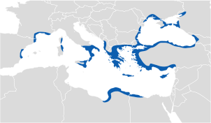
English: Location of Greek ancient. |
||
| Dato | |||
| Kilde | |||
| Opphavsperson |
|
||
| Tillatelse (Gjenbruk av denne filen) |
|

Lisensiering
Jeg, rettighetsinnehaver av dette arbeidet, publiserer det herved under følgende lisens:
Denne filen er lisensiert under lisensen Creative Commons Navngivelse-DelPåSammeVilkår 3.0 Unported
- Du står fritt:
- til å dele – til å kopiere, distribuere og overføre verket
- til å blande – til å endre verket
- Under de følgende betingelsene:
- navngivelse – Du må kreditere verket på passende vis, lenke til lisensen og indikere hvorvidt det har blitt gjort endringer. Du kan gjøre det på enhver rimelig måte, men ikke på en måte som antyder at lisensgiveren støtter deg eller din bruk av verket.
- del på samme vilkår – Dersom du remikser, omarbeider eller på annen måte bygger på dette verket, må du kun distribuere resultatet under den samme eller en samsvarende lisens som denne.
Filhistorikk
Klikk på et tidspunkt for å vise filen slik den var på det tidspunktet.
| Dato/klokkeslett | Miniatyrbilde | Dimensjoner | Bruker | Kommentar | |
|---|---|---|---|---|---|
| nåværende | 15. des. 2016 kl. 15:32 | | 302 × 176 (257 KB) | SilentResident | Fixed map inaccuracies about the Greek kingdoms of Macedonia and Epirus, which were part of the Greek world. Not including them, has caused inaccuracies and inconsistencies on the map, especially in the part where the map displays the Epirote colonies... |
| 8. aug. 2012 kl. 12:04 |  | 302 × 176 (185 KB) | The Emirr | Color change. | |
| 7. aug. 2012 kl. 16:56 |  | 302 × 176 (184 KB) | The Emirr | {{Information |Description ={{en|1=Location of Greek ancient.}} |Source =*[http://www.wwnorton.com/nrl/english/nawol/maps/MAP7GRCO.JPG www.wwnorton.com] |Author ={{click|image=Maplab-logo.svg|link=User:The Emirr/MapLab|width=60px|hei... |
Filbruk
De følgende 2 sidene bruker denne filen:
Global filbruk
Følgende andre wikier bruker denne filen:
- Bruk i af.wikipedia.org
- Bruk i als.wikipedia.org
- Bruk i an.wikipedia.org
- Bruk i ar.wikipedia.org
- Bruk i ast.wikipedia.org
- Bruk i azb.wikipedia.org
- Bruk i az.wikipedia.org
- Bruk i ba.wikipedia.org
- Bruk i be.wikipedia.org
- Bruk i bg.wikipedia.org
- Bruk i br.wikipedia.org
- Bruk i ca.wikipedia.org
- Bruk i ckb.wikipedia.org
- Bruk i cs.wikipedia.org
- Bruk i cy.wikipedia.org
- Bruk i da.wikipedia.org
- Bruk i de.wikipedia.org
- Bruk i diq.wikipedia.org
- Bruk i el.wikipedia.org
- Bruk i en.wikipedia.org
- Bruk i en.wikibooks.org
- Bruk i eo.wikipedia.org
- Bruk i es.wikipedia.org
- Bruk i eu.wikipedia.org
Vis mer global bruk av denne filen.