Fil:La Vérendrye Map.jpg

Opprinnelig fil (1 024 × 364 piksler, filstørrelse: 70 KB, MIME-type: image/jpeg)
| Denne filen er fra Wikimedia Commons og kan brukes av andre prosjekter. Informasjonen fra filbeskrivelsessiden vises nedenfor. |
Beskrivelse
| Beskrivelse |
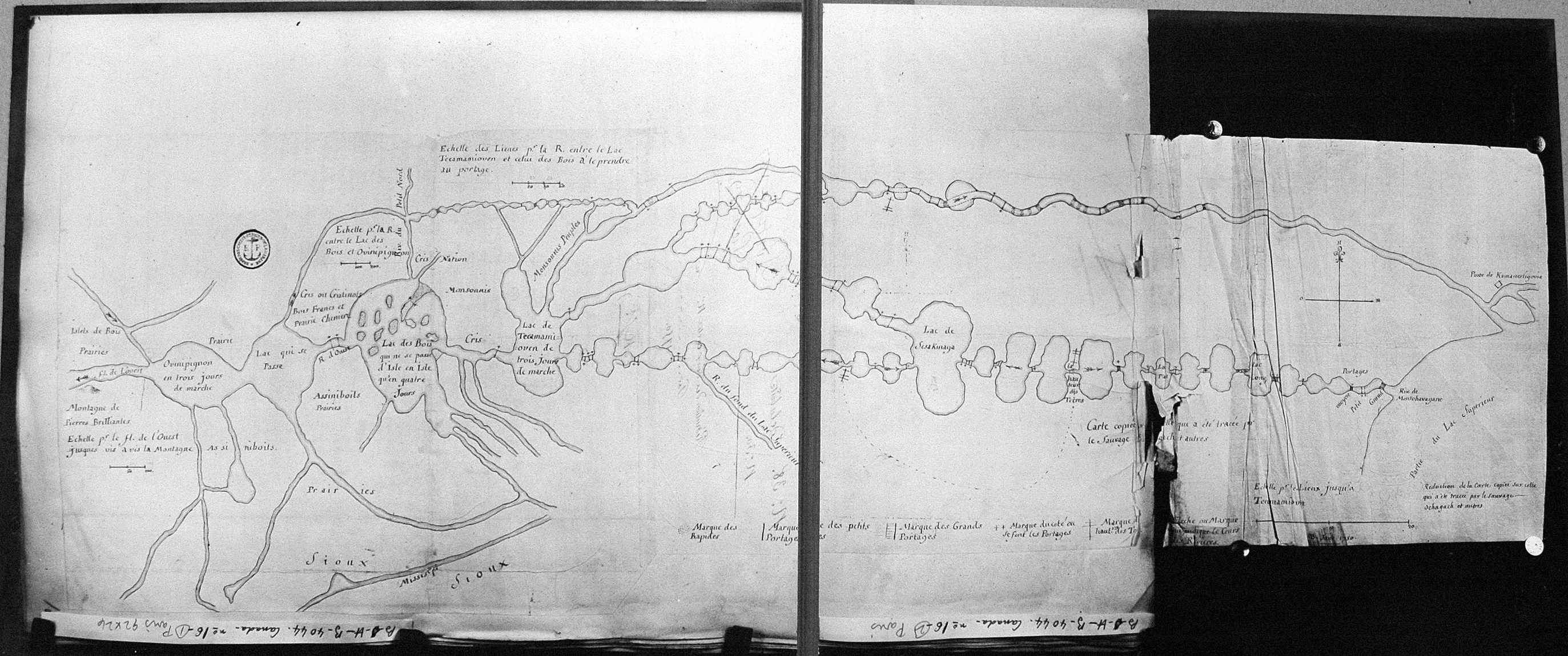
English: Map of Boundary Waters region, including Lake Superior, Kaministiquia River, Rainy Lake, Lake of the Woods, and Lake Winnipeg, drawn by Native guide Auchagah for La Vérendrye sometime around 1730. |
| Dato | ca. 1730 |
| Kilde |
France National Archives http://epe.lac-bac.gc.ca/100/206/301/lac-bac/explorers/data2.collectionscanada.gc.ca/ap/c/c016133.jpg |
| Opphavsperson | Auchagah |
| Tillatelse (Gjenbruk av denne filen) |
© Public Domain Credit: National Archives of Canada/C-016133 |
Lisensiering
|
Dette verket er offentlig eiendom i Norge, EU og land der den opphavsrettslige vernetiden etter opphavsmannens død er 70 år eller kortere. Merk at noen land har lengre vernetid.
| |
| Denne filen har blitt identifisert til å være fri for kjente restriksjoner under lov om opphavsrett, inkludert alle relaterte og nærstående rettigheter. | |
Orginal opplastningslogg
- 2007-03-23 19:02 BlueCanoe 1024×364× (71327 bytes) Map of [[Boundary Waters]] region, including [[Lake Superior]], [[Rainy Lake]], and [[Lake of the Woods]], drawn by Native guide Auchagah for [[Pierre Gaultier de Varennes, sieur de La Vérendrye|La Vérendrye]] © Public Domain Credit: National Archives
External links
- Research Laboratories of Archaeology at University of North Carolina: Ochagach (Cree Indian); La Vérendrye, Pierre Gaultier de Varennes, sieur de (1685-1749) [ca. 1728]: [Carte copiée sur celle qui a été tracée par le sauvage Ochagach et autres, comprenant la région des Grands Lacs, depuis la "montagne de Pierres brilliantes" jusqu'au "Poste de Kamanestigovia", près du lac Supérieur, vers 1750.]
Filhistorikk
Klikk på et tidspunkt for å vise filen slik den var på det tidspunktet.
| Dato/klokkeslett | Miniatyrbilde | Dimensjoner | Bruker | Kommentar | |
|---|---|---|---|---|---|
| nåværende | 22. jun. 2010 kl. 08:27 | 1 024 × 364 (70 KB) | Urdangaray | {{Information |Description={{en|Map of en:Boundary Waters region, including en:Lake Superior, en:Kaministiquia River, en:Rainy Lake, en:Lake of the Woods, and en:Lake Winnipeg, drawn by Native guide Auchagah for [[:en:P |
Filbruk
Den følgende siden bruker denne filen:
Global filbruk
Følgende andre wikier bruker denne filen:
- Bruk i de.wikipedia.org
- Bruk i en.wikipedia.org
- Bruk i es.wikipedia.org
- Bruk i fr.wikipedia.org
- Bruk i it.wikipedia.org