Fil:Kandahar districts.png

Størrelse på denne forhåndsvisningen: 786 × 600 piksler. Andre oppløsninger: 315 × 240 piksler | 629 × 480 piksler | 1 000 × 763 piksler.
Opprinnelig fil (1 000 × 763 piksler, filstørrelse: 30 KB, MIME-type: image/png)
| Denne filen er fra Wikimedia Commons og kan brukes av andre prosjekter. Informasjonen fra filbeskrivelsessiden vises nedenfor. |

|
Dette bildet bør gjenskapes med hjelp av vektorgrafikk som en SVG-fil. Dette har flere fordeler, se Commons:Media for cleanup for mer informasjon. Hvis en SVG-fil med dette bildet er tilgjengelig, vennligst last den opp. Etter opplasting erstatt denne malen med {{vector version available|nytt bilde.svg}}.
|
Beskrivelse

|
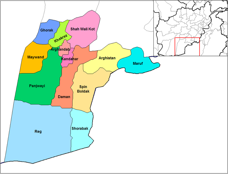
This file requires updating because: Does not include Miyanishin District or Zhari District. Miyanishin was created from the Northern part of Shah Wali Kot. Zhari was created from parts of Maywand and Panjwai In doing so, you could add a timestamp to the file.
|
English: Map of the districts of Kandahar province of Afghanistan. Created by Rarelibra 19:26, 29 March 2007 (UTC) for public domain use, using MapInfo Professional v8.5 and various mapping resources.
Lisensiering
| Jeg, opphavsrettensholderen til dette verket, frigir dette verket til allmennheten. Dette gjelder på verdensbasis. I enkelte land kan dette være juridisk umulig. I så fall: Jeg gir hvem som helst retten til å bruke dette verket for ethvert formål, uten noen vilkår, med mindre slike vilkår kreves ved lov. |
Filhistorikk
Klikk på et tidspunkt for å vise filen slik den var på det tidspunktet.
| Dato/klokkeslett | Miniatyrbilde | Dimensjoner | Bruker | Kommentar | |
|---|---|---|---|---|---|
| nåværende | 15. feb. 2024 kl. 16:47 | | 1 000 × 763 (30 KB) | User-duck | Cropped 5 % horizontally, 6 % vertically using CropTool with lossless mode. |
| 29. mar. 2007 kl. 21:26 |  | 1 056 × 816 (30 KB) | Rarelibra | Map of the districts of Kandahar province of Afghanistan. Created by ~~~~ for public domain use, using MapInfo Professional v8.5 and various mapping resources. |
Filbruk
De følgende 3 sidene bruker denne filen:
Global filbruk
Følgende andre wikier bruker denne filen:
- Bruk i ar.wikipedia.org
- Bruk i bn.wikipedia.org
- Bruk i ca.wikipedia.org
- Bruk i da.wikipedia.org
- Bruk i de.wikipedia.org
- Bruk i en.wikipedia.org
- Bruk i en.wikinews.org
- Bruk i es.wikipedia.org
- Bruk i et.wikipedia.org
- Bruk i fr.wikipedia.org
- Bruk i he.wikipedia.org
- Bruk i incubator.wikimedia.org
- Bruk i it.wikipedia.org
- Bruk i ja.wikipedia.org
- Bruk i lt.wikipedia.org
- Bruk i mn.wikipedia.org
- Bruk i ms.wikipedia.org
- Bruk i nl.wikipedia.org
Vis mer global bruk av denne filen.