Fil:FrancoPrussianWarFrontierJuly1870.jpg

Størrelse på denne forhåndsvisningen: 700 × 600 piksler. Andre oppløsninger: 280 × 240 piksler | 560 × 480 piksler | 896 × 768 piksler | 1 083 × 928 piksler.
Opprinnelig fil (1 083 × 928 piksler, filstørrelse: 1,09 MB, MIME-type: image/jpeg)
| Denne filen er fra Wikimedia Commons og kan brukes av andre prosjekter. Informasjonen fra filbeskrivelsessiden vises nedenfor. |
Beskrivelse
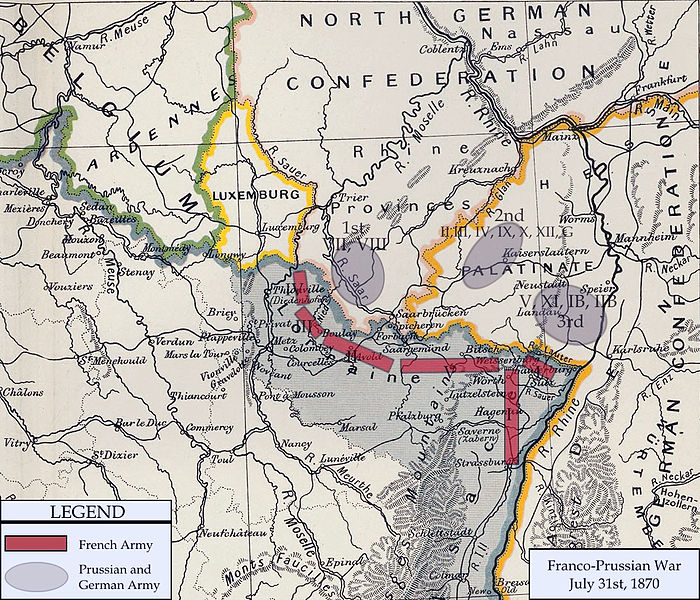
| Beskrivelse | Franco-Prussian War map of 1870 |
| Dato | |
| Kilde | Cambridge Modern History Atlas |
| Opphavsperson | Edited by A.W.Ward, G.W.Prothero, and Stanley Leathes |
I adapted the map to reflect the state of French and Prussian/German armies in July of 1870.
Lisensiering
This media file is in the public domain in the United States. This applies to U.S. works where the copyright has expired, often because its first publication occurred prior to January 1, 1929, and if not then due to lack of notice or renewal. See this page for further explanation.
|
 | |
 |
This image might not be in the public domain outside of the United States; this especially applies in the countries and areas that do not apply the rule of the shorter term for US works, such as Canada, Mainland China (not Hong Kong or Macao), Germany, Mexico, and Switzerland. The creator and year of publication are essential information and must be provided. See Wikipedia:Public domain and Wikipedia:Copyrights for more details.
|
Filhistorikk
Klikk på et tidspunkt for å vise filen slik den var på det tidspunktet.
| Dato/klokkeslett | Miniatyrbilde | Dimensjoner | Bruker | Kommentar | |
|---|---|---|---|---|---|
| nåværende | 15. feb. 2011 kl. 22:13 | | 1 083 × 928 (1,09 MB) | DIREKTOR | Repairs |
| 3. jan. 2008 kl. 23:07 |  | 1 083 × 928 (1,01 MB) | Monsieurdl | {{Information |Description=Franco-Prussian War map of 1870 |Source=Cambridge Modern History Atlas |Date=1912 |Author=Edited by A.W.Ward, G.W.Prothero, and Stanley Leathes }} I adapted the map to reflect the state of French and Prussian/German armies in J | |
| 2. jan. 2008 kl. 23:22 |  | 1 083 × 928 (1,04 MB) | Monsieurdl | {{Information |Description=Franco-Prussian War map of 1870 |Source=Cambridge Modern History Atlas |Date=1912 |Author=Edited by A.W.Ward, G.W.Prothero, and Stanley Leathes }} I adapted the map to reflect the state of French and Prussian/German armies in J |
Filbruk
Den følgende siden bruker denne filen:
Global filbruk
Følgende andre wikier bruker denne filen:
- Bruk i azb.wikipedia.org
- Bruk i bg.wikipedia.org
- Bruk i br.wikipedia.org
- Bruk i cs.wikipedia.org
- Bruk i en.wikipedia.org
- Bruk i hy.wikipedia.org
- Bruk i ja.wikipedia.org
- Bruk i pl.wikipedia.org
- Bruk i sv.wikipedia.org
- Bruk i tr.wikipedia.org
- Bruk i vi.wikipedia.org