Fil:Fires yellowstone.jpg

Størrelse på denne forhåndsvisningen: 800 × 533 piksler. Andre oppløsninger: 320 × 213 piksler | 640 × 427 piksler | 1 080 × 720 piksler.
Opprinnelig fil (1 080 × 720 piksler, filstørrelse: 379 KB, MIME-type: image/jpeg)
| Denne filen er fra Wikimedia Commons og kan brukes av andre prosjekter. Informasjonen fra filbeskrivelsessiden vises nedenfor. |
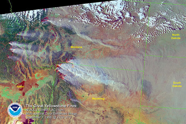
Satellite map with political borders showing the location of Yellowstone in an interesting manner: It is on fire. From 1988.
Note: http://www1.ncdc.noaa.gov/pub/data/images/fires-yellowstone-20020907-n9rgb.jpg was given as the source when it was uploaded 11:35, 14 June 2003 (UTC) by Hfastedge (talk • contribs) to en.wikipedia.
This work is in the public domain in the United States because it is a work prepared by an officer or employee of the United States Government as part of that person’s official duties under the terms of Title 17, Chapter 1, Section 105 of the US Code.
Note: This only applies to original works of the Federal Government and not to the work of any individual U.S. state, territory, commonwealth, county, municipality, or any other subdivision. This template also does not apply to postage stamp designs published by the United States Postal Service since 1978. (See § 313.6(C)(1) of Compendium of U.S. Copyright Office Practices). It also does not apply to certain US coins; see The US Mint Terms of Use.
|
 | |
| Denne filen har blitt identifisert til å være fri for kjente restriksjoner under lov om opphavsrett, inkludert alle relaterte og nærstående rettigheter. | ||
Filhistorikk
Klikk på et tidspunkt for å vise filen slik den var på det tidspunktet.
| Dato/klokkeslett | Miniatyrbilde | Dimensjoner | Bruker | Kommentar | |
|---|---|---|---|---|---|
| nåværende | 29. aug. 2005 kl. 22:17 | | 1 080 × 720 (379 KB) | Huebi~commonswiki | Satellite map with political borders showing the location of Yellowstone in an interesting manner: It is on fire. From 1988. Source: . {{PD-USGov}} Category:Yellowstone National Park\ |
Filbruk
Den følgende siden bruker denne filen:
Global filbruk
Følgende andre wikier bruker denne filen:
- Bruk i de.wikipedia.org
- Bruk i nn.wikipedia.org
- Bruk i pl.wikipedia.org
- Bruk i pt.wikipedia.org
- Bruk i simple.wikipedia.org