Fil:Europe in 1328.png

Opprinnelig fil (2 150 × 2 336 piksler, filstørrelse: 761 KB, MIME-type: image/png)
| Denne filen er fra Wikimedia Commons og kan brukes av andre prosjekter. Informasjonen fra filbeskrivelsessiden vises nedenfor. |
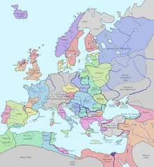
This image shows the state of Europe in the year 1328.
- Significance: w:Philip VI of France founds the w:Valois Dynasty after the death of King Charles IV of France, who has no sons to inherit.
The original image was released into the public domain ("I assert no proprietary interest in these materials but offer them freely for public use. You may copy them, reproduce them, or do whatever you wish with them. I hope that, whatever use you may make of them, they will prove of some value to you.")
Source: [1] [checked 16 Feb 2007- now a bad link, however lead to http://www.vlib.us/glaughead.html, and am querying for new url. FrankB 19:04, 16 February 2007 (UTC)]
I modified it using MS Word (essentially I traced the map details) making it much, much clearer and more attractive. Of course this image as well as the image it is based on is released into the public domain. Details modified also Dec. 26, 2018, according with H.-E. Stier (dir.), Grosser Atlas zur Weltgeschichte, Westermann 1985, (ISBN 3-14-100919-8), p. 71; Putzger historischer Weltatlas, Cornelsen 1990, (ISBN 3-464-00176-8); Georges Duby, Atlas historique, Larousse 1987, (ISBN 2-03-503009-9), André & Jean Sellier 'Atlas des Peuples La Découverte : Orient 1993, (ISBN 2-7071-2222-X), Claude Mutafian & Éric Van Lauwe, Atlas historique de l'Arménie, Autrement, coll. « Atlas / Mémoires », 2005 (ISBN 978-2746701007), p. 56-57.
| Dette verket har blitt frigitt til allmennheten av opphavspersonen Lynn H. Nelson. Dette gjelder på verdensbasis. I enkelte land kan dette være juridisk umulig. I så fall: Lynn H. Nelson gir hvem som helst retten til å bruke dette verket for ethvert formål, uten noen vilkår, med mindre slike vilkår kreves ved lov.
|
.png)
_en.png)
.png)
.jpg)
Filhistorikk
Klikk på et tidspunkt for å vise filen slik den var på det tidspunktet.
| Dato/klokkeslett | Miniatyrbilde | Dimensjoner | Bruker | Kommentar | |
|---|---|---|---|---|---|
| nåværende | 12. aug. 2023 kl. 17:29 | | 2 150 × 2 336 (761 KB) | Gyalu22 | |
| 7. aug. 2023 kl. 16:28 |  | 1 075 × 1 168 (114 KB) | Yuri V. | Novgorod Republic | |
| 7. aug. 2023 kl. 03:22 |  | 1 075 × 1 168 (96 KB) | Yuri V. | Kingdom of Galicia–Volhynia 1199–1349, reverted to version as of 20:03, 7 November 2022 (UTC) | |
| 16. nov. 2022 kl. 17:48 |  | 2 150 × 2 337 (116 KB) | Gyalu22 | Reverted to version as of 07:03, 14 July 2022 (UTC) | |
| 7. nov. 2022 kl. 22:03 |  | 1 075 × 1 168 (96 KB) | Maxglig | Reverted to version as of 18:52, 26 December 2018 (UTC) | |
| 14. jul. 2022 kl. 09:03 |  | 2 150 × 2 337 (116 KB) | Gligan1 | Original version restored | |
| 26. des. 2018 kl. 20:52 |  | 1 075 × 1 168 (96 KB) | Julieta39 | Details according with H.-E. Stier (dir.), ''Grosser Atlas zur Weltgeschichte'', Westermann 1985, (ISBN 3-14-100919-8), p. 71; ''Putzger historischer Weltatlas'', Cornelsen 1990, (ISBN 3-464-00176-8); Georges Duby, ''Atlas historique'', Larousse 1987, (ISBN 2-03-503009-9), André & Jean Sellier '''Atlas des Peuples'' La Découverte : ''Orient'' 1993, (ISBN 2-7071-2222-X), Claude Mutafian & Éric Van Lauwe, ''Atlas historique de l'Arménie'', Autrement, coll. « Atlas / Mémoires », 2005 (ISBN 978-2... | |
| 24. des. 2017 kl. 14:09 |  | 1 075 × 1 168 (101 KB) | Trey Kincaid | I've corrected Sicily, who was at that times an independent kingdom with Federico III as a king. | |
| 28. apr. 2017 kl. 00:53 |  | 1 075 × 1 168 (87 KB) | Santasa99 | Rivers redrawn in blue, some info added and some corrections per Euroatlas - Historical Maps, [http://www.euratlas.net/history/europe/1300/index.html Euratlas Periodis Web - Map of Europe in Year 1300] | |
| 10. mai 2015 kl. 21:35 |  | 1 075 × 1 168 (120 KB) | Artemis Dread | Baia?! |
Filbruk
De følgende 4 sidene bruker denne filen:
Global filbruk
Følgende andre wikier bruker denne filen:
- Bruk i an.wikipedia.org
- Bruk i ar.wikipedia.org
- Bruk i ast.wikipedia.org
- Bruk i az.wikipedia.org
- Bruk i ban.wikipedia.org
- Bruk i ba.wikipedia.org
- Bruk i beta.wikiversity.org
- Bruk i be.wikipedia.org
- Bruk i bg.wikipedia.org
- Bruk i bs.wikipedia.org
- Bruk i bxr.wikipedia.org
- Bruk i ca.wikipedia.org
- Bruk i cs.wikipedia.org
- Bruk i cv.wikipedia.org
- Bruk i da.wikipedia.org
- Bruk i de.wikipedia.org
- Bruk i el.wikipedia.org
- Bruk i en.wikipedia.org
- Bruk i en.wikibooks.org
- Bruk i es.wikipedia.org
- Bruk i et.wikipedia.org
Vis mer global bruk av denne filen.