Fil:Dioecesis Thraciae 400 AD.png
Ingen høyere oppløsning tilgjengelig.
Dioecesis_Thraciae_400_AD.png (461 × 352 piksler, filstørrelse: 205 KB, MIME-type: image/png)
| Denne filen er fra Wikimedia Commons og kan brukes av andre prosjekter. Informasjonen fra filbeskrivelsessiden vises nedenfor. |
Beskrivelse
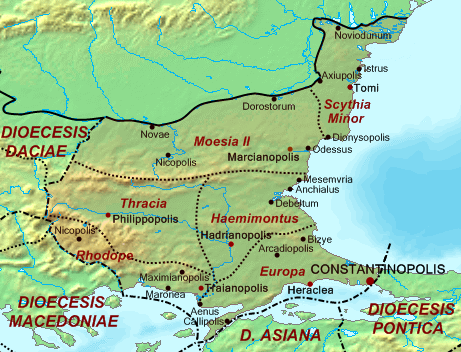
| Beskrivelse | Map of the Diocese of Thrace (Dioecesis Thraciae) ca. 400 AD, showing the subordinate provinces and the major cities. |
| Dato | |
| Kilde |
Base map found at en:Topographic map#Global 1-kilometer map, otherwise self-made. Data based on maps in atlases and the internet and on contemporary sources, primarily the Notitia Dignitatum. Note: The exact course of the provincial boundaries is very uncertain and in many cases only approximate. |
| Opphavsperson | Cplakidas |
Lisensiering
| Jeg, opphavsrettensholderen til dette verket, frigir dette verket til allmennheten. Dette gjelder på verdensbasis. I enkelte land kan dette være juridisk umulig. I så fall: Jeg gir hvem som helst retten til å bruke dette verket for ethvert formål, uten noen vilkår, med mindre slike vilkår kreves ved lov. |
Filhistorikk
Klikk på et tidspunkt for å vise filen slik den var på det tidspunktet.
| Dato/klokkeslett | Miniatyrbilde | Dimensjoner | Bruker | Kommentar | |
|---|---|---|---|---|---|
| nåværende | 20. mai 2017 kl. 16:30 | | 461 × 352 (205 KB) | Julieta39 | Antic shoreline of the Danube mouths since Grigore Antipa's "Black Sea" (1940) and Andrei Nacu's paleomap [https://fr.wikipedia.org/wiki/Delta_du_Danube#/media/File:Danube_Delta_evolution.gif]. |
| 2. okt. 2007 kl. 18:25 |  | 461 × 352 (139 KB) | Cplakidas | {{Information |Description=Map of the Diocese of Thrace (''Dioecesis Thraciae'') ca. 400 AD, showing the subordinate provinces and the major cities. |Source=Base map found at en:Topographic map#Global 1-kilometer map, other |
Filbruk
Den følgende siden bruker denne filen:
Global filbruk
Følgende andre wikier bruker denne filen:
- Bruk i an.wikipedia.org
- Bruk i ar.wikipedia.org
- Bruk i arz.wikipedia.org
- Bruk i az.wikipedia.org
- Bruk i be.wikipedia.org
- Bruk i bg.wikipedia.org
- Bruk i ca.wikipedia.org
- Bruk i cs.wikipedia.org
- Bruk i da.wikipedia.org
- Bruk i de.wikipedia.org
- Bruk i de.wikivoyage.org
- Bruk i el.wikipedia.org
- Bruk i en.wikipedia.org
- Bruk i es.wikipedia.org
Vis mer global bruk av denne filen.