Fil:Bolivia satellite deforestation 1986 2001.jpg
Bolivia_satellite_deforestation_1986_2001.jpg (540 × 448 piksler, filstørrelse: 103 KB, MIME-type: image/jpeg)
| Denne filen er fra Wikimedia Commons og kan brukes av andre prosjekter. Informasjonen fra filbeskrivelsessiden vises nedenfor. |
Beskrivelse
| Beskrivelse |
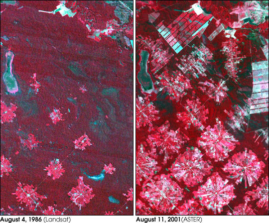
Deforestation in Santa Cruz, Bolivia. From Earth Observatory : "These images from 1986 and 2001 are for an area of tropical dry forest lying east of Santa Cruz de la Sierra, Bolivia. Since the mid-1980s, the resettlement of people from the Altiplano (the Andean high plains) and a large agricultural development effort (the Tierras Baja project) has lead to this area’s deforestation. Soybean production began in earnest in the early 1970s following a substantial increase in the crop’s world price. The pie or radial patterned fields are part of the San Javier resettlement scheme. At the center of each unit is a small community that includes a church, bar/café, school, and soccer field. The rectangular, light colored areas are fields of soybeans cultivated for export, mostly funded by foreign loans. The dark strips running through the fields are windbreaks, which are advantageous because the soils in this area are fine and prone to wind erosion. The 1986 Landsat image (left) was acquired on August 4, 1986, and the ASTER image (right) on August 11, 2001." Image courtesy NASA/GSFC/MITI/ERSDAC/JAROS, and U.S./Japan ASTER Science Team Any and all materials published on the Earth Observatory are freely available for re-publication or re-use, except where copyright is indicated. We ask that NASA's Earth Observatory be given credit for its original materials. |
| Kilde | NASA |
| Opphavsperson | NASA |
Lisensiering
| This file is in the public domain in the United States because it was solely created by NASA. NASA copyright policy states that "NASA material is not protected by copyright unless noted". (See Template:PD-USGov, NASA copyright policy page or JPL Image Use Policy.) | ||
 |
Warnings:
|
Orginal opplastningslogg
- 2005-08-07 18:21 Delorme 540×448×8 (105607 bytes) Deforestation in Santa Cruz, Bolivia. From [[Earth Observatory |http://earthobservatory.nasa.gov/Newsroom/NewImages/images.php3?img_id=16274]] "These images from 1986 and 2001 are for an area of tropical dry forest lying east of Santa Cruz de la Sierra
Filhistorikk
Klikk på et tidspunkt for å vise filen slik den var på det tidspunktet.
| Dato/klokkeslett | Miniatyrbilde | Dimensjoner | Bruker | Kommentar | |
|---|---|---|---|---|---|
| nåværende | 3. jan. 2007 kl. 19:58 | | 540 × 448 (103 KB) | Frog Bot | semi-automatic upload by user:bayo from fr.wikipedia.org "Image:Bolivia satellite deforestation 1986 2001 .jpg" |
Filbruk
Den følgende siden bruker denne filen:
Global filbruk
Følgende andre wikier bruker denne filen:
- Bruk i fr.wikipedia.org
- Bruk i it.wikipedia.org