Fil:Aerial view Loos-Hulluch trench system July 1917.jpg

Opprinnelig fil (742 × 864 piksler, filstørrelse: 542 KB, MIME-type: image/jpeg)
| Denne filen er fra Wikimedia Commons og kan brukes av andre prosjekter. Informasjonen fra filbeskrivelsessiden vises nedenfor. |
| Beskrivelse |
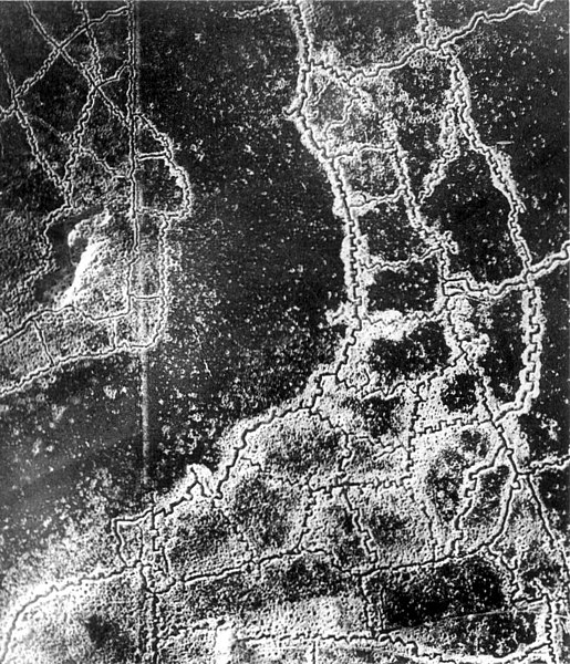
English: An aerial reconnaissance photograph of the opposing trenches and no-man's land between Loos-en-Gohelle and Hulluch in Artois, France, taken at 7.15 pm, 22 July 1917. German trenches are at the right and bottom, British trenches are at the top left. The vertical line to the left of centre indicates the course of a pre-war road or track.
The location is Hill 70, attacked and taken between 15 and 25 August 1917 by the Canadian Corps. Français : Photographie de reconnaissance aérienne des tranchées adverses et du no-man's-land qui les sépare. Les tranchées allemandes sont en bas à droite, les tranchées à gauches sont anglaises. La ligne verticale sur la gauche est tout ce qui reste d'une route. Photo prise entre Loos et Hulluch, en Artois (France) à 19h15, le 22 juillet 1917.
Русский: Аэрофотосъемка траншей (окопов) и ходов сообщения противников и разделяющей их ничейной земли, Западноевропейский театр войны. Справа внизу немецкие окопы, слева — английские, канадские. Вертикальная линия слева — это всё, что осталось от дороги. Аэроснимок сделан между Лоосом и Хюлухом, в Артуа (Франция) в 19.15, 22 июля 1917 года. |
|||
| Dato | ||||
| Kilde |
|
|||
| Opphavsperson | Ukjent | |||
| Tillatelse (Gjenbruk av denne filen) |
|


| Kameraposisjon | | Dette og andre bilder på denne posisjonen på: OpenStreetMap |
|---|
Note: Location is approximate.

|
This image has been assessed under the valued image criteria and is considered the most valued image on Commons within the scope: World War I trench systems, aerial view. You can see its nomination here. |
Filhistorikk
Klikk på et tidspunkt for å vise filen slik den var på det tidspunktet.
| Dato/klokkeslett | Miniatyrbilde | Dimensjoner | Bruker | Kommentar | |
|---|---|---|---|---|---|
| nåværende | 16. jan. 2012 kl. 05:12 | | 742 × 864 (542 KB) | Centpacrr | Remove text. |
| 10. des. 2005 kl. 07:49 |  | 767 × 864 (243 KB) | Gsl~commonswiki | {{PD-BritishGov}} |
Filbruk
De følgende 2 sidene bruker denne filen:
Global filbruk
Følgende andre wikier bruker denne filen:
- Bruk i ast.wikipedia.org
- Bruk i az.wikipedia.org
- Bruk i be-tarask.wikipedia.org
- Bruk i be.wikipedia.org
- Bruk i bg.wikipedia.org
- Bruk i br.wikipedia.org
- Bruk i ca.wikipedia.org
- Bruk i da.wikipedia.org
- Bruk i de.wikipedia.org
- Bruk i en.wikipedia.org
- Bruk i es.wikipedia.org
- Bruk i et.wikipedia.org
- Bruk i fa.wikipedia.org
- Bruk i fi.wikipedia.org
- Bruk i fr.wikipedia.org
- Bruk i fr.wikiversity.org
- Bruk i gl.wikipedia.org
- Bruk i hu.wikipedia.org
- Bruk i hy.wikipedia.org
- Bruk i id.wikipedia.org
- Bruk i it.wikipedia.org
- Bruk i it.wikiquote.org
- Bruk i ja.wikipedia.org
- Bruk i ko.wikipedia.org
- Bruk i ml.wikipedia.org
- Bruk i ms.wikipedia.org
- Bruk i nl.wikipedia.org
- Bruk i nl.wiktionary.org
- Bruk i oc.wikipedia.org
- Bruk i pcd.wikipedia.org
- Bruk i pl.wikipedia.org
Vis mer global bruk av denne filen.