Fil:2010 Haiti earthquake USGS map.png
Ingen høyere oppløsning tilgjengelig.
2010_Haiti_earthquake_USGS_map.png (411 × 455 piksler, filstørrelse: 30 KB, MIME-type: image/png)
| Denne filen er fra Wikimedia Commons og kan brukes av andre prosjekter. Informasjonen fra filbeskrivelsessiden vises nedenfor. |
Beskrivelse
| Beskrivelse |
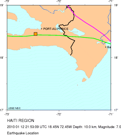
English: Location of the 2010 Haiti earthquake |
| Dato | |
| Kilde | USGS - [1] |
| Opphavsperson | USGS |
Lisensiering
This image is in the public domain in the United States because it only contains materials that originally came from the United States Geological Survey, an agency of the United States Department of the Interior. For more information, see the official USGS copyright policy.
|
Orginal opplastningslogg
| Dato/klokkeslett | Dimensjoner | Bruker | Kommentar |
|---|---|---|---|
| 13. januar 2010, 01:41:06 | 411 × 455 (24797 bytes) | Bsimmons666 (diskusjon · bidrag) | {{Information |Description={{en|1=Location of the 2010 Haiti earthquake}} |Source=USGS - [http://neic.usgs.gov/neis/bulletin/neic_rja6_l.html] |Author=USGS |Date=January 12, 2010 |Permission= |other_versions= }} [[Category:Earthquakes of 2010]] |
Filhistorikk
Klikk på et tidspunkt for å vise filen slik den var på det tidspunktet.
| Dato/klokkeslett | Miniatyrbilde | Dimensjoner | Bruker | Kommentar | |
|---|---|---|---|---|---|
| nåværende | 21. jul. 2014 kl. 12:06 | | 411 × 455 (30 KB) | GifTagger | Bot: Converting file to superior PNG file. (Source: 2010_Haiti_earthquake_USGS_map.gif). This GIF was problematic due to transparency and non-greyscale color table. |
Filbruk
Den følgende siden bruker denne filen:
Global filbruk
Følgende andre wikier bruker denne filen:
- Bruk i ast.wikipedia.org
- Bruk i de.wikipedia.org
- Bruk i es.wikipedia.org