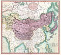
Fil:1806 Cary Map of Tartary or Central Asia - Geographicus - Tartary-cary-1806.jpg

Opprinnelig fil(5 000 × 4 569 piksler, filstørrelse: 8,57 MB, MIME-type: image/jpeg)


Wikimedia Commons' logo
John Cary: A New Map of Mongolian & Independent Tartary , From the Latest Authorities.   (Wikidata search (Cirrus search) Wikidata query (SPARQL)  Create new Wikidata item based on this file)
Kunstner
John Cary  (–1835)  wikidata:Q3446124 s:en:Author:John Cary
 
Alternative navn
J. Cary
Beskrivelse kartograf, gravør, mapseller, printseller og grafiker
Fødsels-/dødsdato 23. februar 1755 / 1754 Redigere på wikidata 16. august 1835 Redigere på wikidata
Føde-/dødssted Corsley Mortlake
Arbeidsperiode 1788 / 1793 / 1797 Redigere på wikidata
Arbeidssted
Autoritetsregister
artist QS:P170,Q3446124
Tittel
A New Map of Mongolian & Independent Tartary , From the Latest Authorities.
Beskrivelse
English: An exceptionally beautiful example of John Cary’s important 1806 map of Mongolian and Independent Tartary. Covers Central Asia from the Caspian Sea to Japan, extends as far north as the Obskaia Sea and as far south as India, Burma and the Philippines. Includes the modern day nations of Uzbekistan, Kazakhstan, Turkmenistan, Kirgizstan, Tajikistan and Mongolia. One of Cary’s most interesting maps. Central Asia, despite hundreds of years of passing trade on the Silk Routes, was still, at the turn of the century a largely unknown land. Cary attempts to show some of the Silk Route passages, especially to the north of the Gobi, but ultimately admits, “The Geography of these parts is extremely obscure.” All in all, one of the most interesting and few maps of Central Asia to appear in first years of the 19th century. Prepared in 1806 by John Cary for issue in his magnificent 1808 New Universal Atlas. (NOTE: The reproduction of the colors in this map appear to be incorrect, as Japan and Tibet were never part of Chinese Tartary yet appear to be the same color as it.)
Dato 1806 (dated)
Dimensjoner høyde: 18,5 in (46,9 cm); bredde: 20 in (50,8 cm)
dimensions QS:P2048,18.5U218593
dimensions QS:P2049,20U218593
Museumsnummer
Geographicus link: Tartary-cary-1806
Kilde/Fotograf

Cary, John, Cary's New Universal Atlas, containing distinct maps of all the principal states and kingdoms throughout the World. From the latest and best authorities extant. London: Printed for J. Cary, Engraver and Map-seller, No. 181, near Norfolk Street, Strand, 1808.

Tillatelse
(Gjenbruk av denne filen)
This is a faithful photographic reproduction of a two-dimensional, public domain work of art. The work of art itself is in the public domain for the following reason:
Public domain

Dette verket er offentlig eiendom i Norge, EU og land der den opphavsrettslige vernetiden etter opphavsmannens død er 100 år eller kortere. Merk at noen land har lengre vernetid.


For å kunne lagres på Commons må verket både være offentlig eiendom i USA og i opphavslandet. Vernetiden kan i noen tilfeller være lengre enn 80 år i USA, så i tillegg til dette merket trengs det et eget merke som forklarer hvorfor verket er offentlig eiendom (public domain) i USA.
The official position taken by the Wikimedia Foundation is that "faithful reproductions of two-dimensional public domain works of art are public domain".
This photographic reproduction is therefore also considered to be in the public domain in the United States. In other jurisdictions, re-use of this content may be restricted; see Reuse of PD-Art photographs for details.
Andre versjoner
Annotations
InfoField
This image is annotated: View the annotations at Commons

Bildetekster

Legg til en kort forklaring på hva filen representerer

Elementer som er med i denne fila

motiv

image/jpeg

3d7f1be3ae7a9539d26d91394bee37e7dc951779

8 990 511 byte

4 569 piksel

5 000 piksel

Filhistorikk

Klikk på et tidspunkt for å vise filen slik den var på det tidspunktet.

Dato/klokkeslettMiniatyrbildeDimensjonerBrukerKommentar
nåværende19. aug. 2019 kl. 10:56Miniatyrbilde av versjonen fra 19. aug. 2019 kl. 10:565 000 × 4 569 (8,57 MB)SoerfmBrightness, color
22. mar. 2011 kl. 12:56Miniatyrbilde av versjonen fra 22. mar. 2011 kl. 12:565 000 × 4 569 (7,81 MB)BotMultichillT{{subst:User:Multichill/Geographicus |link=http://www.geographicus.com/P/AntiqueMap/Tartary-cary-1806 |product_name=1806 Cary Map of Tartary or Central Asia |map_title=A New Map of Chinese & Independent Tartary , From the Latest Authorities. |description=

Den følgende siden bruker denne filen:

Global filbruk

Følgende andre wikier bruker denne filen:

Metadata